
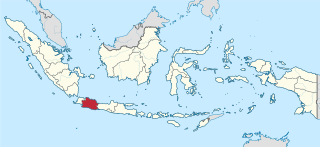
Banten is the westernmost province on the island of Java, Indonesia. Its capital city is Serang and its largest city is Tangerang. The province borders West Java and the Special Capital Region of Jakarta on the east, the Java Sea on the north, the Indian Ocean on the south, and the Sunda Strait on the west and shares a maritime border with Bengkulu and Lampung to the east and Bangka Belitung Islands to the north. The province covers an area of 9,352.77 km2 (3,611.12 sq mi). It had a population of over 11.9 million in the 2020 census, up from about 10.6 million in 2010. The estimated mid-2023 population was 12.308 million. Formerly part of the province of West Java, Banten was split off to become a province on 17 October 2000.

Madura Island is an Indonesian island off the northeastern coast of Java. The island comprises an area of approximately 4,436.77 square kilometres (1,713.05 sq mi). Administratively, Madura is part of the province of East Java. It is separated from Java by the narrow Madura Strait. The administered area had a density of 755.6 people per km2 in mid 2023, while the main island had a somewhat higher figure of 840 per km2.
West Java is an Indonesian province on the western part of the island of Java, with its provincial capital in Bandung. West Java is bordered by the province of Banten and the country's capital region of Jakarta to the west, the Java Sea to the north, the province of Central Java to the east and the Indian Ocean to the south. With Banten, this province is the native homeland of the Sundanese people, the second-largest ethnic group in Indonesia.

East Java is a province of Indonesia located in the easternmost third of Java island. It has a land border only with the province of Central Java to the west; the Java Sea and the Indian Ocean border its northern and southern coasts, respectively, while the narrow Bali Strait to the east separates Java from Bali by around 2.29 kilometres (1.42 mi). Located in eastern Java, the province also includes the island of Madura, as well as the Kangean islands and other smaller island groups located further east and Masalembu archipelagos in the north. Its capital is Surabaya, the second largest city in Indonesia, a major industrial center and also a major business center. Banyuwangi is the largest regency in East Java and the largest on the island of Java.

West Kalimantan is a province of Indonesia. It is one of five Indonesian provinces comprising Kalimantan, the Indonesian part of the island of Borneo. Its capital and largest city is Pontianak. It is bordered by East Kalimantan and Central Kalimantan to the east, the Malaysian state of Sarawak to the north, and the Pacific Ocean to the west and the Java Sea to the south. The province has an area of 147,037 km2, and had a population of 4,395,983 at the 2010 Census and 5,414,390 at the 2020 Census; the official estimate as at mid 2023 was 5,623,328. Ethnic groups include the Dayak, Malay, Chinese, Javanese, Bugis, and Madurese. The borders of West Kalimantan roughly trace the mountain ranges surrounding the vast watershed of the Kapuas River, which drains most of the province. The province shares land borders with Central Kalimantan to the southeast, East Kalimantan to the east, and the Malaysian territory of Sarawak to the north.

Lampung, officially the Province of Lampung, is a province of Indonesia. It is located on the southern tip of the island of Sumatra. It has a short border with the province of Bengkulu to the northwest, and a longer border with the province of South Sumatra to the north, as well a maritime border with the province of Banten and Jakarta to the east. It is the original home of the Lampung people, who speak their own language, and possess their own written script. Its capital is Bandar Lampung.
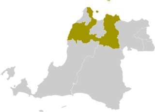
Serang Regency is a regency of Banten province, Indonesia. It is located in the northwest corner of the island of Java. The administrative center of the regency is at Ciruas, while the capital of the province is the independent municipality of Serang which was split off the regency on 17 July 2007.

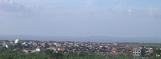
Cilacap Regency is a regency in the southwestern part of Central Java province in Indonesia. Its capital is the town of Cilacap.

The Kangean Islands or simply Kangean is a collective name for a group of islands lying to the east of Madura. Kangean and its surrounding islands lie to the north of Bali in the northern Bali Sea, to the northwest of the Lesser Sunda Islands, and administratively they form three districts within Sumenep Regency, East Java Province. The group comprises a total of 91 islands including 27 inhabited islands. Kangean is located approximately 120 km (75 mi) in the north of Bali, the northwest of Lombok, and 120 km east of Madura. The biggest and most populous district is Arjasa, which includes the town of that name located in the west of the island. The Kangean Islands have a large potential for natural resources, such as natural gas, teak, coconut, and salt production.

Pamekasan Regency is a regency (kabupaten) of the province of East Java, Indonesia. It is located on Madura Island approximately 120 kilometres (75 mi) east of Surabaya, the provincial capital. The regency covers an area of 792.30 square kilometres (305.91 sq mi), and at the 2010 census it had a population of 795,918 ; at the 2020 census the total was 850,057 and the official estimate as of mid-2023 was 882,837 – comprising 431,891 males and 450,946 females. The administrative capital is the town of Pamekasan.

Ponorogo Regency is an inland regency of East Java Province of Indonesia. It is considered the birthplace of Reog Ponorogo, a traditional Indonesian dance form. The regency covers an area of 1,371.78 km2 (529.65 sq mi), and it had a population of 855,281 at the 2010 census and 949,318 at the 2020 census; the official estimate as of mid-2023 was 959,500. The capital of the kabupaten is the local town of Ponorogo located around 30 km (19 mi) south of the main East Java city of Madiun and 65 km (40 mi) south of the town of Ngawi.

Sumenep Regency is a regency of the East Java province, Indonesia. It has an area of 2,093.47 km2 and a population of 1,042,312 inhabitants according to the 2010 census ; the 2020 census resulted in a total of 1,124,436. The official estimate as at mid 2023 was 1,142,210.
Madura Strait is a stretch of water that separates the Indonesian islands of Java and Madura, in the province of East Java. The islands of Kambing, Giliraja, Genteng, and Ketapang lie in the Strait. The Suramadu Bridge, the longest in Indonesia, spans the strait between Surabaya on Java and Bangkalan on Madura.

The Masalembu Islands are the islands that lie in the Java Sea to the north of Madura, about halfway between Madura and Borneo. They administratively form Masalembu District (kecamatan) of Sumenep Regency of Madura, in the Indonesian province of East Java. The Madurese language is spoken on the islands. The three main islands are Masalembu Island, Masakambing Island, and Karamian Island. The land area of the district is 40.85 square km, and it had a population of 20,687 people in the 2000 census, increasing to 21,705 in the 2010 Census and to 25,809 in the 2020 Census.

Lepar is an island in Indonesia, located off the southeastern coast of Bangka. Administratively part of South Bangka in Bangka Belitung province, it is the third-largest island in the province after its much larger namesakes Bangka and Belitung, with an area of 169 square km. Lepar sits in the Gaspar Strait which separates the two larger islands. It stretches about 22 km east–west and 17 km north–south, with the towns of Tanjunglabu, Tanjungsangkar and Penutuk being the main population centers. It is governed as its own district of Lepar Pongok, which used to include a nearby, medium-sized island of Pongok until 2012 when it separated as its own district of Pongok Islands.
Masalembu is an island located in the Java Sea and is the largest island in the Masalembu Islands. It is administered by the Masalembu District of the Sumenep Regency which is centered on the island of Madura and is made up of two administrative villages of Sukajeruk and Massalima.
Masakambing is a small Indonesian island in the Masalembu Islands of the Java Sea and is part of the regency of Sumenep. It is administered as the village of Masakambing.

Leti leti is a type of traditional transport vessel from East Madura, Indonesia, especially from the administrative district of Sumenep. The leti leti is a recent development, the hull form and sail were developed in the 19th century. In 1979, sailing leti leti numbered about 1,000, but the number reduced over the next decades as more modern, motorized vessel appeared.

The Kangeanese are an Austronesian ethnic group native to the Indonesian island of Kangean and its surrounding islands. The Kangeanese population of c.125,840 live mostly on the island of Kangean, making up c.90% of the island's population.
Atar is a nagari (village) in Padang Ganting, Tanah Datar Regency, in the Indonesian province of West Sumatra, with a population of just under 5,000 people.
