A unitary authority is a type of local authority that has a single tier and is responsible for all local government functions within its area or performs additional functions which elsewhere in the relevant country are usually performed by national government or a higher level of sub-national government.
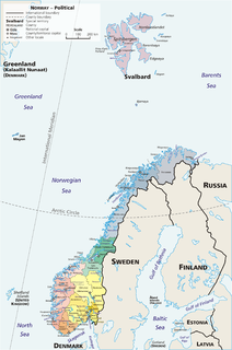
Norway is divided into 18 administrative regions, called counties ; until 1918, they were known as amter. The counties form the first-level subdivisions of Norway and are further divided into 422 municipalities. The island territories of Svalbard and Jan Mayen are outside the county division and ruled directly at the national level. The capital Oslo is considered both a county and a municipality.

The Northern District is one of Israel's six administrative districts. The Northern District has a land area of 4,478 km², which increases to 4,638 km² when both land and water are included. The district capital and largest city in the North District is Nazareth.
Finland is divided into 70 sub-regional units. The sub-regions are formed by groups of municipalities within the 19 regions of Finland. The sub-regions represent a LAU 1 level of division used in conjunction with the Nomenclature of Territorial Units for Statistics.

The Eastern Province of Kenya was one of 8 Provinces of Kenya. Its northern boundary ran along with that of Ethiopia; the North Eastern Province and Coast Province lay to the east and south; and the remainder of Kenya's provinces, including Central Province, ran along its western border. The provincial capital was Embu.

There are six main administrative districts of Israel, known in Hebrew as mehozot and Arabic as mintaqah and fifteen sub-districts known as nafot. Each sub-district is further divided into cities, municipalities, and regional councils it contains.
Lira District is a district in Northern Uganda. Like many other Ugandan districts, it is named after its 'chief town', Lira.

The Northern Great Plain is a statistical region of Hungary. It is part of the Great Plain and North region. The Northern Great Plain includes the counties of Hajdú-Bihar, Jász-Nagykun-Szolnok, and Szabolcs-Szatmár-Bereg, with a total area of 17,749 km2 (6,853 sq mi) and a population of around 1.5 million.
The wards and electoral divisions in the United Kingdom are electoral districts at sub-national level represented by one or more councillors. The ward is the primary unit of English electoral geography for civil parishes and borough and district councils, electoral ward is the unit used by Welsh principal councils, while the electoral division is the unit used by English county councils and some unitary authorities. Each ward/division has an average electorate of about 5,500 people, but ward-population counts can vary substantially. As at the end of 2014 there were 9,456 electoral wards/divisions in the UK.

Amolatar District is a district in Northern Uganda. Like many other Ugandan districts, it is named after its main municipal and administrative centre, Amolatar Town.

Poienile de sub Munte is a commune in Maramureș County, northern Romania. It is one of the oldest places in Maramureș, being mentioned for the first time in 1353. It is the biggest commune in the county and is composed of a single village, Poienile de sub Munte.
Băița de sub Codru is a commune in Maramureș County, northern Romania. It is composed of two villages, Băița de sub Codru and Urmeniș (Bükkörményes).
Northern Star Council is a Boy Scout Council headquartered in Saint Paul, Minnesota. The council was formerly the Viking Council and Indianhead Council until the two councils merged on July 1, 2005. The council serves communities across central Minnesota and western Wisconsin, encompassing 25 counties.
Abim District is a district in Northern Uganda. It's named after its 'chief town', Abim, where the district headquarters are located.

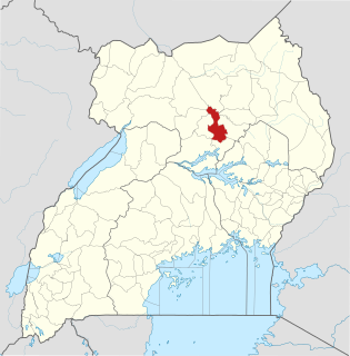
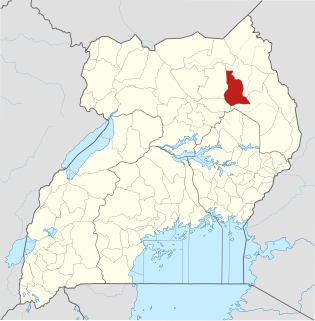
The regions of Uganda are known as Central, Western, Eastern, and Northern. These four regions are in turn divided into districts. There were 56 districts in 2002, which expanded into 111 districts plus one city (Kampala) by 2010.

Maracha District is a district in the West Nile sub-region, in the Northern Region of Uganda. It was formed in 2006 from Arua District.

Buvuma District is a district in the Central Region of Uganda. The district is coterminous with the Buvuma Islands archipelago in Lake Victoria and does not have territory on mainland Uganda.

Kole District is a district in Northern Uganda. Like most other Ugandan districts, it is named after its 'chief town', Kole, where the district headquarters are located.