
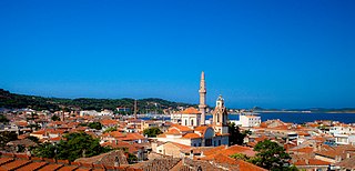
Mytilene is the capital of the Greek island of Lesbos, and its port. It is also the capital and administrative center of the North Aegean Region, and hosts the headquarters of the University of the Aegean. It was founded in the 11th century BC.

The North Aegean Region is one of the thirteen administrative regions of Greece, and the smallest of the thirteen by population. It comprises the islands of the north-eastern Aegean Sea, called the North Aegean islands, except for Thasos and Samothrace, which belong to the Greek region of Eastern Macedonia and Thrace, and Imbros and Tenedos, which belong to Turkey.

Vrisa is a village in the southern part of Lesbos island approximately 50 km from Mytilene. The village is named after one of the two girls Agamemnon took from Lesbos during the ten-year Trojan War. Five kilometers south is the famous Vatera beach. On June 12, 2017 Vrisa was severely damaged in an earthquake that struck approximately 12 km South of the town of Plomari. Most people could not return to their homes, rendering the village effectively a "ghost village".
Hellanicusof Lesbos, also called Hellanicus of Mytilene, was an ancient Greek logographer who flourished during the latter half of the 5th century BC.
Eresos and its twin beach village Skala Eresou are located in the southwest part of the Greek island of Lesbos. They are villages visited by considerable numbers of tourists. From 1999 until 2010, Eresos and the village of Antissa constituted the municipality of Eresos-Antissa. From 2010 until 2019, Eresos was part of the municipality of Lesvos and from 2019 it is part of the municipality of West Lesvos.
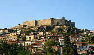
Mithymna is a town and former municipality on the island of Lesbos, North Aegean, Greece. Since the 2019 local government reform it is part of the municipality of West Lesbos, of which it is a municipal unit. Before 1919, its official name was Μόλυβος - Molyvos; that name dates back to the end of the Byzantine Era, but is still in common use today.

Lesbos or Lesvos is a Greek island located in the northeastern Aegean Sea. It has an area of 1,633 km2 (631 sq mi), with approximately 400 kilometres of coastline, making it the third largest island in Greece and the eighth largest in the Mediterranean. It is separated from Asia Minor by the narrow Mytilini Strait. On the southeastern coast is the island's capital and largest city, Mytilene (Μυτιλήνη), whose name is also used for the island as a whole. Lesbos is a separate regional unit with the seat in Mytilene, which is also the capital of the larger North Aegean region. The region includes the islands of Lesbos, Chios, Ikaria, Lemnos, and Samos. The total population of the island was 83,755 in 2021. A third of Lesbians live in the capital, while the remainder are concentrated in small towns and villages. The largest are Plomari, Kalloni, the Gera Villages, Agiassos, Eresos, and Molyvos.
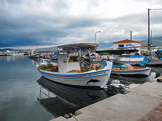
Gera or Yera is a town on the Aegean island of Lesbos in Greece. It once stood as one of the largest ports of the island. According to scholars the ancient name may have been Portus Hieraeus; Pliny the Elder mentions a Lesbian city called Hiera, which was abandoned before his time.
Ayvalık, formerly also known as Kydonies, is a municipality and district of Balıkesir Province, Turkey. Its area is 305 km2, and its population is 74,030 (2022). It is a seaside town on the northwestern Aegean coast of Turkey. The town centre is connected to Cunda Island by a causeway and is surrounded by the archipelago of Ayvalık Islands, which face the nearby Greek island of Lesbos.

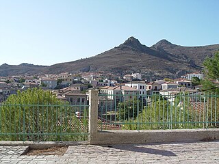
Antissa was a city of the island Lesbos (Lesvos), near to Cape Sigrium, the western point of Lesbos. The place had a harbour. The ruins found by Richard Pococke at Calas Limneonas, a little NE. of cape Sigri, may be those of Antissa. This place was the birthplace of Terpander, who is said to be the inventor of the seven-stringed lyre. According to the local historian Myrsilus of Methymna, local tradition held that the head of Orpheus had floated south from the Hebros after he was decapitated and floated south to land on the shore of Antissan territory: the spot was marked by a tomb where, according to Myrsilus, the nightingales sang more sweetly than they did elsewhere.
Kalloni is a town in the west-central part of the island of Lesbos, Greece. It is the seat of the West Lesbos municipality and the Kalloni municipal unit within it. Prior to 2011 the current municipal unit was a municipality. The name also existed in ancient times, though the conventional transcription of the classical name in English is "Callone".

Loutropoli Thermis is a village and a former municipality on the island of Lesbos, North Aegean, Greece. Since the 2019 local government reform it is part of the municipality Mytilene, of which it is a municipal unit. It is located on the central east coast of the island. It has a land area of 79.468 km2. Its population was 2,772 at the 2021 census. Loutrópoli Thermís was the seat of the municipality that comprises Loutrópoli Thermís, Pigi, Komi, Mistegna and Nees Kydonies. The largest towns are Loutrópoli Thermís, Mistegná, Nées Kydoníes, and Pigí.

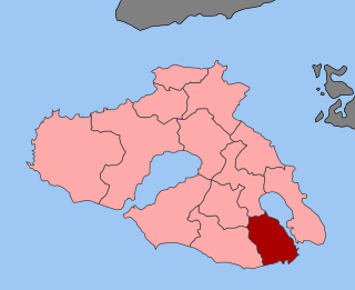
Plomari is a town and a former municipality on the island of Lesbos, North Aegean, Greece. Since the 2019 local government reform it is part of the municipality Mytilene, of which it is a municipal unit. It is the only sizable coastal settlement in the south, and the second largest town on Lesbos. The municipal unit of Plomari is the southernmost on Lesbos Island and has a land area of 122.452 km2 and a 2021 census population of 4,852. Its largest towns or villages are Plomári, the former municipal seat, Plagiá, Palaiochóri, Megalochóri, and Akrási.
Antandrus or Antandros was an ancient Greek city on the north side of the Gulf of Adramyttium in the Troad region of Anatolia. Its surrounding territory was known in Greek as Ἀντανδρία (Antandria), and included the towns of Aspaneus on the coast and Astyra to the east. It has been located on Devren hill between the modern village of Avcılar and the town of Altınoluk in the Edremit district of Balıkesir Province, Turkey.

Evergetoulas is a former municipality on the island of Lesbos, North Aegean, Greece. Since the 2019 local government reform it is part of the municipality Mytilene, of which it is a municipal unit. It is located in the eastern part of the island, inland from the Aegean Sea, but on the Bay of Gera. It has a land area of 88.866 km². Its population was 2,438 at the 2021 census. The seat of the municipality was in Sykounta. Its largest towns are Íppeio, Káto Trítos, Kerameía, Sykoúnta, and Asómatos.

Theophilos Chatzimichail, known simply as Theophilos, was a Greek folk painter and major contributor in modern Greek art. The main subject of his works are Greek characters and the illustration of Greek traditional folklore and history.

Cyme or Cumae was an Aeolian city in Aeolis close to the kingdom of Lydia. It was called Phriconian, perhaps from the mountain Phricion in Aeolis, near which the Aeolians had been settled before their migration to Asia.

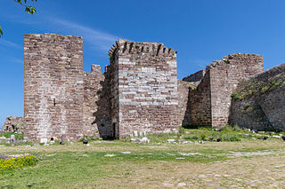
The Castle of Mytilene, also Fortress of Mytilene, is located in Mytilene on the Greek island of Lesbos, North Aegean. It is maintained in good condition and is one of the largest castles in the Mediterranean covering an area of 60 acres. The first castle on the site may have been erected during the time of Justinian I. The 6th-century castle may have been built on top of an already existent fortress. In the Late Middle Ages, the castle was the residence of Francesco I Gattilusio and his successors, especially the tower known today as the Queen's Tower. There is also strong evidence that the original acropolis on the site may have included a sanctuary to Demeter, Kore and Cybele.
The Ottoman conquest of Lesbos took place in September 1462. The Ottoman Empire, under Sultan Mehmed II, laid siege to the island's capital, Mytilene. After its surrender, the other forts of the island surrendered as well. The event put an end to the semi-independent Genoese lordship that the Gattilusio family had established in the northeastern Aegean since the mid-14th century, and heralded the beginning of the First Ottoman–Venetian War in the following year.
Agia Marina is a village on the island of Lesbos, North Aegean, Greece. Since the 2019 local government reform it is part of the municipality of Mytilene.
