
The Gulf of Finland is the easternmost arm of the Baltic Sea. It extends between Finland to the north and Estonia to the south, to Saint Petersburg in Russia to the east, where the river Neva drains into it. Other major cities around the gulf include Helsinki and Tallinn. The eastern parts of the Gulf of Finland belong to Russia, and some of Russia's most important oil harbors are located farthest in, near Saint Petersburg. As the seaway to Saint Petersburg, the Gulf of Finland has been and continues to be of considerable strategic importance to Russia. Some of the environmental problems affecting the Baltic Sea are at their most pronounced in the shallow gulf. Proposals for a tunnel through the gulf have been made.

The Niagara Escarpment is a long escarpment, or cuesta, in Canada and the United States that starts from the south shore of Lake Ontario westward, circumscribes the top of the Great Lakes Basin running from New York through Ontario, Michigan, and Wisconsin. The escarpment is the cliff over which the Niagara River plunges at Niagara Falls, for which it is named.

Toompea is a hill in the central part of Tallinn, the capital city of Estonia. The hill has an area of 7 hectares and is about 20–30 metres higher than the surrounding areas. Toompea is part of the medieval Tallinn Old Town, a UNESCO World Heritage Site.

The Narva, formerly also Narwa or Narova, flows 77 kilometres (48 mi) north into the Baltic Sea and is the largest Estonian river by discharge. A similar length of land far to the south, together with it and a much longer intermediate lake, Lake Peipus, all together nowadays form the international border between Estonia and Russia.

The Onondaga Limestone is a group of hard limestones and dolomites of Devonian age that forms geographic features in some areas in which it outcrops; in others, especially its Southern Ontario portion, the formation can be less prominent as a local surface feature.

The Ngonye Falls or Sioma Falls is a waterfall on the Zambezi river in Western province Zambia, near the town of Sioma and a few hundred kilometres upstream from the Victoria Falls. Situated in the southern part of Barotseland, the falls are a day's journey by car from the capital, Lusaka. Their inaccessibility makes them much less known than Victoria Falls. The Ngonye Falls Community Partnership Park is located at the falls.

Keila is a town and an urban municipality in Harju County in north-western Estonia, 25 km (16 mi) southwest of Tallinn. As of 2021, the town has a population of 10,499 inhabitants.
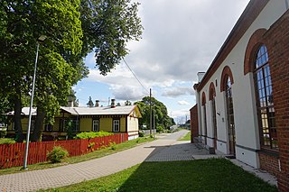
Aegviidu is a borough in Anija Parish, Harju County, Estonia, most known for its picturesque surroundings and hiking trails.
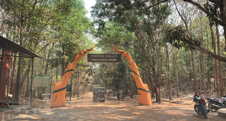
Kanger Valley National Park is a national park in the Bastar region of Chhattisgarh state in India. It came into existence in July 1982 and covers an area of approximately 200 square kilometres (77 sq mi). The park extends from the Teerathagarh waterfalls in the west to the Kolab river in the east, spanning an average length of 33.5 km (20.8 mi) and an average width of 6 km (3.7 mi) from north to south. It derives its name from the Kanger river, which flows centrally through it. Situated at a distance of 30 km (19 mi) southeast of Jagdalpur city, it is one of India's densest national parks and is known for its biodiversity, landscape, waterfalls, and subterranean geomorphologic limestone caves. It is also the home to the Bastar hill myna, the state bird of Chhattisgarh.
The Sinimäed Hills are three linked hills in northeastern Estonia. The heights which are aligned west–east, consist of Tornimägi, Põrguaugu mägi and Pargimägi. They lie in Narva-Jõesuu municipality near the coastal town of Sillamäe in Ida-Viru County.

Lasnamäe is the most populous administrative district of Tallinn, the capital of Estonia. The district's population is about 119,000, the majority of which is Russian-speaking. Local housing is mostly represented by 5–16 stories high panel blocks of flats, built in the 1970–1990s.
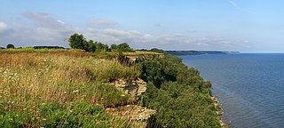
The Baltic Klint is an erosional limestone escarpment and cuesta on several islands of the Baltic Sea, in Estonia, in Leningrad Oblast of Russia and in the islands of Gotland and Öland of Sweden. It was featured on the reverse of the 50 krooni note of 1928 and on the 100 krooni note of 1992.
Valaste Falls is the highest waterfall in Estonia and neighboring regions. It is located between Ontika and Valaste in Toila Parish of Ida-Viru County and is formed by Valaste Creek as it flows over the Baltic Klint not far from the shore of the Gulf of Finland. It is a popular tourist attraction, with its spray freezing up in winter.
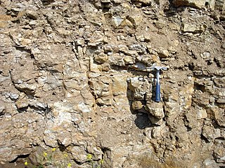
There are two kinds of oil shale in Estonia, both of which are sedimentary rocks laid down during the Ordovician geologic period. Graptolitic argillite is the larger oil shale resource, but, because its organic matter content is relatively low, it is not used industrially. The other is kukersite, which has been mined for more than a hundred years. Kukersite deposits in Estonia account for 1% of global oil shale deposits.

Valgejõgi is a river in Northern Estonia. Its source is in Lake Porkuni in Pandivere and it drains into Hara Bay at Loksa.

Maarjamäe is a subdistrict in the district of Pirita, Tallinn, the capital of Estonia. It is bordered by Pirita and Kose to the north, Lasnamäe to the south, Kadriorg to the southwest and the Bay of Tallinn to the west. As of 2022, it has a population of 2,412.

Jägala Waterfall is a waterfall in northern Estonia on the Jägala River. It is the largest natural waterfall in Estonia, with a width of about 50 meters (160 ft) and a height of about 8 meters (26 ft). Jägala Waterfall is located in Koogi in Harju County. Jägala Waterfall is also the most powerful waterfall in Estonia, cascading 12.8 cubic meters per second (450 cu ft/s) of water. It can even reach 200 cubic meters per second (7,100 cu ft/s) during spring in high water periods. Though, the cascade stops in the winter, freezing over.

Narva Falls is a waterfall on the Narva River in Estonia and Russia.

Aluoja Falls is a waterfall in northern Estonia. It is located in the village of Pühajõe in Toila Parish, Ida-Viru County.

