
Geodesy is the Earth science of accurately measuring and understanding Earth's figure, orientation in space, and gravity. The field also incorporates studies of how these properties change over time and equivalent measurements for other planets. Geodynamical phenomena, including crustal motion, tides and polar motion, can be studied by designing global and national control networks, applying space geodesy and terrestrial geodetic techniques and relying on datums and coordinate systems.

A digital elevation model (DEM) is a 3D computer graphics representation of elevation data to represent terrain, commonly of a planet, moon, or asteroid. A "global DEM" refers to a discrete global grid. DEMs are used often in geographic information systems, and are the most common basis for digitally produced relief maps.

The World Geodetic System (WGS) is a standard for use in cartography, geodesy, and satellite navigation including GPS. This standard includes the definition of the coordinate system's fundamental and derived constants, the normal gravity Earth Gravitational Model (EGM), a description of the associated World Magnetic Model (WMM), and a current list of local datum transformations.
Figure of the Earth is a term of art in geodesy that refers to the size and shape used to model Earth. The size and shape it refers to depend on context, including the precision needed for the model. The sphere is an approximation of the figure of the Earth that is satisfactory for many purposes. Several models with greater accuracy have been developed so that coordinate systems can serve the precise needs of navigation, surveying, cadastre, land use, and various other concerns.

In geodesy, a reference ellipsoid is a mathematically defined surface that approximates the geoid, which is the truer, imperfect figure of the Earth, or other planetary body, as opposed to a perfect, smooth, and unaltered sphere, which factors in the undulations of the bodies' gravity due to variations in the composition and density of the interior, as well as the subsequent flattening caused by the centrifugal force from the rotation of these massive objects . Because of their relative simplicity, reference ellipsoids are used as a preferred surface on which geodetic network computations are performed and point coordinates such as latitude, longitude, and elevation are defined.

In satellite laser ranging (SLR) a global network of observation stations measures the round trip time of flight of ultrashort pulses of light to satellites equipped with retroreflectors. This provides instantaneous range measurements of millimeter level precision which can be accumulated to provide accurate measurement of orbits and a host of important scientific data. The laser pulse can also be reflected by the surface of a satellite without a retroreflector, which is used for tracking space debris.
Reino Antero Hirvonen (1908–1989) was a famous Finnish physical geodesist, also well known for contributions in mathematical and astronomical geodesy.

Friedrich Robert Helmert was a German geodesist and an important writer on the theory of errors.
Satellite geodesy is geodesy by means of artificial satellites—the measurement of the form and dimensions of Earth, the location of objects on its surface and the figure of the Earth's gravity field by means of artificial satellite techniques. It belongs to the broader field of space geodesy. Traditional astronomical geodesy is not commonly considered a part of satellite geodesy, although there is considerable overlap between the techniques.
Stellar triangulation is a method of geodesy and of its subdiscipline space geodesy used to measure Earth's geometric shape. Stars were first used for this purpose by the Finnish astronomer Yrjö Väisälä in 1959, who made astrometric photographs of the night sky at two stations together with a lighted balloon probe between them.
Hellmut H. Schmid was Professor of geodesy and photogrammetry on the ETH Zürich (Switzerland), where he emerited in 1985. In the 1950s, he worked on research projects of space exploration in the United States. Between 1968 and 1974, he promoted the first intercontinental network of satellite geodesy.
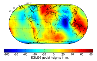
The Earth Gravitational Models (EGM) are a series of geopotential models of the Earth published by the National Geospatial-Intelligence Agency (NGA). They are used as the geoid reference in the World Geodetic System.
Karl Ramsayer was a German geodesist and is well known as one of the most important scientists in geodetic astronomy and in electronic navigation.
Karl Ledersteger was an important geodesist and geophysicist.
In geodesy and astrometry, earth orientation parameters (EOP) describe irregularities in the rotation of planet Earth. EOP provide the rotational transform from the International Terrestrial Reference System (ITRS) to the International Celestial Reference System (ICRS), or vice versa, as a function of time.
Prof. em. Dr. Armin Gruen is, since 1984, professor and head of the Chair of photogrammetry at the Institute of Geodesy and Photogrammetry (IGP), Federal Institute of Technology (ETH) Zurich, Switzerland. Since 1 August 2009, he is retired and is now with the Chair of Information Architecture, ETH Zurich Faculty of Architecture. He is currently acting as a principal investigator on the Simulation Platform of the SEC-FCL in Singapore.

Ernst Heinrich Bruns was a German mathematician and astronomer, who also contributed to the development of the field of theoretical geodesy.
Least-squares adjustment is a model for the solution of an overdetermined system of equations based on the principle of least squares of observation residuals. It is used extensively in the disciplines of surveying, geodesy, and photogrammetry—the field of geomatics, collectively.
Hans-Georg Wenzel, also known as George Wenzel, was a German geodesist, geophysicist and university lecturer. His most important field of work was physical geodesy, where he worked after his dissertation on earth tides with geophysical measurements up to global models of the earth gravity field.

The TUM Department of Aerospace and Geodesy is a department of the Technical University of Munich, located in Ottobrunn. It combines the field of aerospace engineering with research in satellite navigation, earth observation and the basic geodetic disciplines.