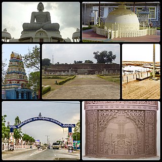
Amaravathi is a village on the banks of the Krishna River, in the Palnadu district of the Indian state of Andhra Pradesh. It is the headquarters of Amaravathi mandal, and forms part of the Andhra Pradesh Capital Region with its headquarters at new Amaravati 35 km (22 mi) east, whose name is also borrowed from that of the older Amaravathi.

Guntur district is one of the twenty six districts in the Coastal Andhra region of the Indian state of Andhra Pradesh. The administrative seat of the district is located at Guntur, the largest city of the district in terms of area and with a population of 670,073. It has a coastline of approximately 100 km (62 mi) on the right bank of Krishna River, that separates it from Krishna district and NTR district. It is bounded on the south by Bapatla district and on the west by Palnadu district. It has an area of 2,443 km2 (943 sq mi) and with a population of 20,91,075 as per 2011 census of India.

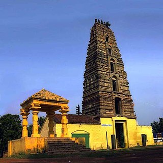
Markapuram is a town in Prakasam district of the Indian state of Andhra Pradesh. It is a municipality and is the headquarters of Markapuram mandal in Markapuram revenue division. Markapuram is notable for the Chennakesava Swamy Temple, built by King Sri Krishnadevaraya. During Ratha Yatra there occurs a popular carnival; the town is also famous for Chenna Kesavaswamy on the day of Rathsapthami, which is attended by thousands of people coming from different parts of the state. It is the second-largest town in Prakasam district after Ongole and it is the main place within West Prakasam district to avail all facilities.
Macherla is a town in Palnadu district of the Indian state of Andhra Pradesh. It is the headquarters of Macherla mandal in Gurazala revenue division.

Vinukonda is a town in Palnadu district of the Indian state of Andhra Pradesh. It is a municipality and the headquarters of Vinukonda mandal and administered under Narasaraopet revenue division.

Durgi is a village in Palnadu district of the Indian state of Andhra Pradesh. It is the mandal headquarters of Durgi mandal in Gurazala revenue division. In 15th century, Durgi stone craft was originated in the village.
Kondramutla is a village in Guntur district of the Indian state of Andhra Pradesh. It is located in Ipur mandal of Guntur revenue division.
Chandur is a census town and Municipality and it is a Mandal Headquarters of Chandur Mandal in Nalgonda district & in the state of Telangana, India. It is located in Chandur mandal of Nalgonda division Postal code or Pin code: 508255. A beautiful and peaceful town. There are various legends about the etymology of the name one of the folklore says Chandi uuru as there is a famous Chandi maata temple of which the deity resembles to the goddess Durga of Vijayawada and is said to be commenced at the same time of the famous temple.

Chebrolu is a village in Guntur district of the Indian state of Andhra Pradesh. It is the headquarters of Chebrolu mandal in Tenali revenue division. It was once a Buddhist site and territorial capital of Kakatiya dynasty. The Archaeological excavations revealed Buddhist artefacts of Satavahana and Ikshavaku period.

Gurazala is a town in Palnadu district in the Indian state of Andhra Pradesh. It is the headquarters of Gurazala mandal, Gurazala Assembly constituency and Gurazala revenue division. It was formed as a municipality combining two panchayats of Gurazala-Jangamaheswarapuram in 2020 by the government of Andhra Pradesh. The town has a history over 800+ years in the historical palnadu times and served as the headquarters/capital of the region during that time.
Dachepalle town is the Municipality in Palnadu district of the Indian state of Andhra Pradesh.Town is the second lime city of India. It is the headquarters of Dachepalle mandal. This is place is surrounded by good limestone resources.
Ipur is a village in Palnadu district of the Indian state of Andhra Pradesh. It is the headquarters of Ipur mandal in Narasaraopet revenue division.
Karempudi is a village in Palnadu district of the Indian state of Andhra Pradesh. It is the headquarters of Karempudi mandal in Gurazala revenue division.
Machavaram is a village in Palnadu district of the Indian state of Andhra Pradesh. It is the headquarters of Machavaram mandal in Gurazala revenue division.
Muppalla (Muppalla) is a village palnadu district of the Indian state of Andhra Pradesh. It is located in Muppalla village ipur mondal of Guntur revenue division.
Pedakakani is a village in the Guntur district of the Indian state of Andhra Pradesh. It is located in Pedakakani mandal of Guntur revenue division. Hindu shrine of Shiva, Sri Bhramaramba Malleswara Swamy Temple is located in the village.
Cherlagudipadu is a village in Palnadu district of the Indian state of Andhra Pradesh. It is located in Gurazala mandal of Gurazala revenue division.
Rayavaram is a village in Palnadu district of the Indian state of Andhra Pradesh. It is located in Macherla mandal of Gurazala revenue division.
Chittapuram is a village in Guntur district of the Indian state of Andhra Pradesh. It is located in Ipur mandal of Guntur revenue division.
Nadimpalle is a village in Guntur district of the Indian state of Andhra Pradesh. It is the located in Cherukupalle mandal of Tenali revenue division.


