The Nurek Dam is an earth-fill embankment dam on the Vakhsh River in Tajikistan. Its primary purpose is hydroelectric power generation and its power station has an installed capacity of 3,015 MW. Construction of the dam began in 1961 and the power station's first generator was commissioned in 1972. The last generator was commissioned in 1979 and the entire project was completed in 1980 when Tajikistan was still a republic within the Soviet Union, becoming the tallest dam in the world at the time. At 300 m (984 ft), it is currently the second tallest man-made dam in the world, after being surpassed by Jinping-I Dam in 2013. The Rogun Dam, also along the Vakhsh in Tajikistan, may exceed it in size when completed.

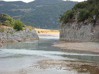
The Stratos Hydroelectric Dam is a dam on the river Acheloos in Aetolia-Acarnania, western Greece. It is situated just east of the village Stratos, and 9 km northwest of Agrinio. The dam created the Stratos artificial lake. There are four more dams upstream from the Stratos Dam: the Kastraki Dam, the Kremasta Dam, the Sykia Dam and the Mesochora Dam.

The Xiluodu Dam is an arch dam on the Jinsha River, i.e. the upper course of the Yangtze in China. It is located near the town of Xiluodu in Yongshan County of Yunnan Province but the dam straddles into Leibo County of Sichuan Province on the opposite side of the river. The primary purpose of the dam is hydroelectric power generation and its power station has an installed capacity of 13,860 MW. Additionally, the dam provides for flood control, silt control and its regulated water releases are intended to improve navigation downstream. Construction on the dam and power station began in 2005 and the first generator was commissioned in 2013, the last in 2014. It is operated by China Yangtze Power and is currently the third-largest power station with the fourth-tallest dam in the world.

Nuozhadu Dam is an embankment dam on the Lancang (Mekong) River in Yunnan Province, southwest China. The dam is 261.5 m (858 ft) tall, and creates a reservoir with a normal capacity of 21,749,000,000 m3 (17,632,000 acre⋅ft) at a level of 812 m (2,664 ft) asl. The purpose of the dam is hydroelectric power production along with flood control and navigation. The dam supports a power station with nine generators, each with generating capacity of 650 MW. The total generating capacity of the power station is 5,850 MW. Construction on the project began in 2004; the dam's first generator went online 6 September 2012 and the last generator was commissioned in June 2014. The construction and management of the project was implemented by Huaneng Power International Ltd., which has a concession to build, own and operate hydroelectric dams on China's stretch of the Mekong River.
The Laxiwa Dam is an arch dam on the Yellow River in Qinghai Province, northwest China. It is 32 km (20 mi) downstream of the Longyangxia Dam and 73 km (45 mi) upstream from the Lijiaxia Dam. The main purpose of the dam is hydroelectric power generation and it supports the largest station in the Yellow River basin. The facility generates power by utilizing six turbines, each with a generating capacity of 700 MW, totaling to a capacity of 4,200 MW.

The Ertan Dam is an arch dam on the Yalong River, a tributary of the Yangtze River in Sichuan Province, southwest China.

The Mingachevir Dam is the largest hydroelectric power station in the South Caucasus, is located over Kur river and not far from Mingachevir city.

Seimare Dam, also known as Hini Mini or spelled Seymareh, is an arch dam on the Seimare River in Badreh County, Ilam Province, Iran. The primary purpose of the dam is hydroelectric power generation. Studies for the dam were carried out in the mid to late 1970s and construction began on the diversion works in 1997. In 2006, concrete placement began and on 19 May 2011, the dam began to impound the river. The dam's first generator became operational in 2013. The power plant, located downstream, houses three 160 MW Francis turbine-generators with an installed capacity of 480 MW.

The Machadinho Hydroelectric Power Plant is a dam and hydroelectric power plant on the Pelotas River near Machadinho on the border of Santa Catarina and Rio Grande do Sul, Brazil. The power station has a 1,140 MW (1,530,000 hp) capacity and is supplied with water by a concrete face rock-fill embankment dam. It is owned and operated by Machadinho Energetica and produces the equivalent of 37% of the energy consumed in Santa Catarina.

The Longyangxia Dam is a concrete arch-gravity dam at the entrance of the Longyangxia canyon on the Yellow River in Gonghe County, Qinghai Province, China. The dam is 178 metres (584 ft) tall and was built for the purposes of hydroelectric power generation, irrigation, ice control and flood control. The dam supports a 1,280 MW power station with 4 x 320 MW generators that can operate at a maximum capacity of 1400 MW. Controlling ice, the dam controls downstream releases to reservoirs lower in the river, allowing them to generate more power instead of mitigating ice. Water in the dam's 24.7 billion m3 reservoir provides irrigation water for up to 1,000,000 hectares of land.
The Silin Dam is a concrete gravity dam on the Wu River in Sinan County, Guizhou Province, China. The dam has an associated hydroelectric power plant with a 1,080 MW capacity utilizing 4 x 270 MW Francis turbine-generators. The dam is 310 m (1,017 ft) long, 117 m (384 ft) high and composed of roller-compacted concrete. Its reservoir has a 1,205,000,000 m3 (976,909 acre⋅ft) capacity, 184,000,000 m3 (149,171 acre⋅ft) of which is flood storage. The dam also supports ship lift. Construction on the dam began in October 2004, the dam began to impound the river in March 2008 and by May 2009, the power plant's first generator was operational. The remaining generators were operational by December 2009.
The Wujiangdu Dam is an arch-gravity dam on the Wu River south of Zunyi, Guizhou Province, China. The purpose of the dam is hydroelectric power generation, flood control and navigation. The dam's power stations contain five generators for a total installed capacity of 1,130 MW.

Stave Falls Dam is a dual-dam power complex on the Stave River in Stave Falls, British Columbia, Canada. The dam was completed in 1912 for the primary purpose of hydroelectric power production. To increase the capacity of Stave Lake, the dam was raised in 1925 and the Blind Slough Dam constructed in an adjacent watercourse 500 m (1,600 ft) to the north, which was the site of the eponymous Stave Falls. In 2000, the dam's powerhouse was replaced after a four-year upgrade. The powerhouse was once British Columbia's largest hydroelectric power source and is a National Historic Site of Canada.

The Ichari Dam is a concrete gravity dam on the Tons River 13 km (8 mi) north of Dakpathar in Uttarakhand, India. The primary purpose of the dam is hydroelectric power production and it is a run-of-the-river-type. It was completed in 1972. The dam diverts water to the Chibro Power Station which is then returned to the Tons River before being fed to the Khodri Power Station.

The Maneri Dam is a concrete gravity dam on the Bhagirathi River located at Maneri, 8.5 kilometres (5.3 mi) east of Uttarkashi in Uttarkashi district, Uttarakhand, India. The primary purpose of the dam is to divert water into a tunnel which feeds the 90 megawatts (120,000 hp) run-of-the-river Tiloth Power Plant.

The Okutadami Dam (奥只見ダム) is a concrete gravity dam on the Tadami River, 26 km (16 mi) east of Uonuma on the border of Niigata and Fukushima Prefectures, Japan. The primary purpose of the dam is hydroelectric power generation and it supports a 560 MW power station which is the largest conventional hydroelectric power station in Japan. The dam also forms the second largest reservoir in Japan, next to that of the Tokuyama Dam.
The Dongfeng Dam is an arch dam on the Wu River 65 km (40 mi) northwest of Qingzhen in Guizhou Province, China. The primary purpose of the dam is hydroelectric power generation and it supports a 570 MW power station. Construction on the dam began in 1989 and the first generator was operational in 1994, the last in 1995. The generators were up-rated between 2004 and 2005; bringing their capacity from 170 MW each to 190 MW.
The Fengshuba Dam is a concrete gravity dam on the Dong River in Longchuan County, Guangdong Province, China. The primary purpose of the dam is hydroelectric power generation and it has an installed capacity of 150 MW. Construction on the dam began in May 1970, the first generator was operational in December 1973 and the second in November 1974. The 95.4 m (313 ft) tall dam withholds a reservoir of 1,932,000,000 m3 (1,566,298 acre⋅ft).

The Mesochora Dam is concrete-face rock-fill dam on the Acheloos River near Mesochora in Trikala, Greece. The 150 m (490 ft) tall dam is part of the Acheloos River Diversion which is intended to divert a portion of the Acheloos west to irrigate 240,000–380,000 ha in the Thessaly plains. The project includes the Mesochora, Sykia, Mouzaki and Pyli Dams along with a 17.4 km (10.8 mi) long channel.
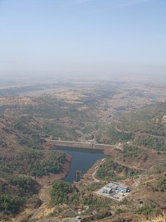
Ghatghar Dam refers to two associated gravity dams built using roller-compacted concrete, the first use in India. They are situated in Ghatghar village in Ahmednagar district Maharashtra, India. Both dams create a lower and upper reservoir for the 250 MW pumped-storage hydroelectric power station. The upper Ghatghar dam is 15 m (49 ft) tall and on the Pravara River, a tributary of Godavari river. The lower Ghatghar dam is 86 m (282 ft) tall and located on the Shahi Nalla which is a tributary of Ulhas River to the south west of the upper reservoir in a steep valley. The hydro power project diverts Godavari river basin water outside the basin area to a west flowing river of Western ghats.