Katakwi

Last updated
Katakwi
Uganda location map.svg
Red pog.svg
Katakwi
Map of Uganda showing the location of Katakwi.
Coordinates: 01°54′54″N33°57′18″E / 1.91500°N 33.95500°E / 1.91500; 33.95500
CountryUganda
Region Eastern Region of Uganda
Sub-region Teso sub-region
District Katakwi District
Elevation
1,100 m (3,600 ft)
Population
 (2020 Estimate)
  Total9,100
Time zone UTC+3 (EAT)

Katakwi is a town in the Eastern Region of Uganda. It is the main municipal, administrative, and commercial center of Katakwi District and the site of the district headquarters. [1]

Contents

Location

Katakwi is approximately 52 kilometres (32 mi), by road, northeast of Soroti, the largest city in the Teso sub-region. [2] This is about 153 kilometres (95 mi), by road, northwest of Mbale, the largest city in Uganda's Eastern Region. [3] Katakwi is approximately 343 kilometres (213 mi), by road, northeast of Kampala, the capital of Uganda and its largest city. [4] The coordinates of the town are 01°54'54.0"N, 33°57'18.0"E (Latitude:1.9150; Longitude:33.9550). [5]

Population

The 2002 national census estimated the town's population at 5,900. In 2010, the Uganda Bureau of Statistics (UBOS) estimated the population at 8,100. In 2011, UBOS estimated the population at 8,400 people. [6]

In 2015 the population of the town was projected at 8,000. In 2020 the mid-year population of Katakwi Town Council was projected at 9,100. It was calculated that the population of the town increased at an average annual rate of 2.6 percent between 2015 and 2020. [7]

Historical population
YearPop.±%
20025,900    
20108,100+37.3%
20118,400+3.7%
20158,000−4.8%
20209,100+13.7%
source: [6] [7]

Points of interest

The following additional points of interest lie within the town limits or close to the edges of town: (1) Stanbic Bank Uganda Limited maintains a branch in town [8] (2) the offices of Katakwi Town Council (3) Katakwi central market (4) Katakwi General Hospital, a public hospital administered by the Uganda Ministry of Health (5) the Soroti–Katakwi–Moroto–Lokitanyala Road passes through the middle of town. [5]

See also

Related Research Articles

<span class="mw-page-title-main">Soroti District</span> District in Eastern Uganda, Uganda

Soroti District is a district in Eastern Uganda. It is named after its chief municipal, administrative and commercial headquarters, Soroti, where the district headquarters are located.

<span class="mw-page-title-main">Soroti</span> Ugandan town

Soroti is a city in Eastern Region of Uganda. It is the main city, commercial, and administrative center in Soroti District, one of the nine administrative districts in the Teso sub-region. Soroti city was immediately approved for operationalization ahead of schedule by the Parliament of Uganda in the Financial Year 2020/2021.

<span class="mw-page-title-main">Mbale</span> Place in Eastern Uganda, Uganda

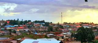
Mbale is a city in the Eastern Region of Uganda. It is the main municipal, administrative, and commercial center of Mbale District and the surrounding sub-region.

<span class="mw-page-title-main">Moroto Town</span> Place in Northern Region, Uganda

Moroto is a town in Moroto District in the Northern Region of Uganda. The town serves as the location of the district headquarters.

Budaka is a town in the Eastern Region of Uganda. It is the chief town of Budaka District, and the district headquarters are located there.

Kapchorwa is a town in the Eastern Region of Uganda. It is the main municipal, commercial, and administrative center of Kapchorwa District. Initially, the town of Kapchorwa was known as the Sebei Region.

Kaberamaido is a town in Eastern Uganda. It is the main municipal, administrative and commercial center of Kaberamaido District and is the location of the headquarters for the district.

Amuria is a town in the Eastern Region of Uganda. It is the chief municipal, administrative, and commercial center of Amuria District, in the Teso sub-region.

Serere is a town in Eastern Uganda. It is the chief political, administrative and commercial town in Serere District, and the district headquarters are located there. The district is named after the town.

Kumi Town, commonly called Kumi, is a town in the Eastern Region of Uganda. It is the main municipal, administrative, and commercial center in Kumi District and is the site of the district headquarters.

Manafwa is a town in the Eastern Region of Uganda. It is the largest town in Manafwa District and the site of the district headquarters.

Busolwe is a town in the Eastern Region of Uganda. It is one of the two municipalities in Butaleja District, the other being Butaleja.

Bukedea is a town in the Eastern Region of Uganda. It is the chief municipal, administrative, and commercial center of Bukedea District, and the district headquarters are located there.

Abim is a town in the Northern Region of Uganda. It is the chief municipal, administrative, and commercial center of Abim District. The district is named after the town.

<span class="mw-page-title-main">Ngora District</span> District in Eastern Region of Uganda, Uganda

Ngora District is a district in the Eastern Region of Uganda. The town of Ngora is the site of the district headquarters.

Ngora is a town in the Eastern Region of Uganda. It is the main political, administrative, and commercial centre of Ngora District.

Napak is a town in Northern Uganda. It is the commercial, administrative and municipal headquarters of Napak District. The district is named after the town.

Ngora Freda Carr Hospital, commonly known as Ngora Hospital, is a community hospital in Uganda. It is affiliated with the Anglican Church of Uganda. It was founded in 1922. It has capacity of 180 beds.

The Soroti–Dokolo–Lira Road is a road in Uganda, connecting the towns of Soroti in Soroti District, Dokolo in Dokolo District, and Lira in Lira District.

Katakwi General Hospital, also Katakwi Hospital is a government-owned hospital in the Eastern Region of Uganda.

References

  1. John Ogulei (15 July 2021). "Katakwi Town Council Officials on spot over Garbage Collection". The Tower Post. Kampala. Retrieved 9 August 2022.
  2. Google (9 August 2022). "Road Distance Between Soroti, Eastern Region, Uganda And Katakwi, Eastern Region, Uganda" (Map). Google Maps . Google. Retrieved 9 August 2022.
  3. Google (9 August 2022). "Road Distance Between Mbale, Eastern Region, Uganda And Katakwi, Eastern Region, Uganda" (Map). Google Maps . Google. Retrieved 9 August 2022.
  4. Google (9 August 2022). "Road Distance Between Kampala, Central Region, Uganda And Katakwi, Eastern Region, Uganda" (Map). Google Maps . Google. Retrieved 9 August 2022.
  5. 1 2 Google (9 August 2022). "Location of Katakwi Town, Eastern Region, Uganda" (Map). Google Maps . Google. Retrieved 9 August 2022.
  6. 1 2 Uganda Bureau of Statistics (June 2011). "Estimated Population of Katakwi In 2002, 2010 And 2011" (PDF). Uganda Bureau of Statistics . Kampala, Uganda. Archived from the original (Archived from the original on 7 July 2014) on 7 July 2014. Retrieved 9 August 2022.
  7. 1 2 Citypopulaton.de (14 June 2020). "The population development of Katakwi Town Council as well as related information and services" (Source: Uganda Bureau of Statistics). Citypopulation.de. Retrieved 9 August 2022.
  8. Google (13 May 2016). "Location of Stanbic Bank Uganda Limited: Katakwi Branch" (Map). Google Maps . Google. Retrieved 13 May 2016.

01°54′54″N33°57′18″E / 1.91500°N 33.95500°E / 1.91500; 33.95500