
Katanga was one of the four large provinces created in the Belgian Congo in 1914. It was one of the eleven provinces of the Democratic Republic of the Congo between 1966 and 2015, when it was split into the Tanganyika, Haut-Lomami, Lualaba, and Haut-Katanga provinces. Between 1971 and 1997, its official name was Shaba Province.

Northern Rhodesia was a protectorate in south central Africa, formed in 1911 by amalgamating the two earlier protectorates of Barotziland-North-Western Rhodesia and North-Eastern Rhodesia. It was initially administered, as were the two earlier protectorates, by the British South Africa Company (BSAC), a chartered company, on behalf of the British Government. From 1924, it was administered by the British Government as a protectorate, under similar conditions to other British-administered protectorates, and the special provisions required when it was administered by BSAC were terminated.

Copperbelt Province is a province in Zambia which covers the mineral-rich Copperbelt, and farming and bush areas to the south. It was the backbone of the Northern Rhodesian economy during British colonial rule and fuelled the hopes of the immediate post-independence period, but its economic importance was severely damaged by a crash in global copper prices in 1973. The province adjoins the Haut-Katanga province of the Democratic Republic of the Congo, which is similarly mineral-rich.
The Bangweulu Block is a cratonic unit that forms part of the Congo craton of central Africa. The Bangweulu Block however consists of Palaeoproterozoic granitoids and volcanics, and is overlain by a Palaeoproterozoic continental sedimentary succession, the Mporokoso Group, and does not preserve much direct evidence of Archaean protoliths.

The Copperbelt is a natural region in Central Africa which sits on the border region between northern Zambia and the southern Democratic Republic of Congo. It is known for copper mining.

Shinkolobwe, or Kasolo, or Chinkolobew, or Shainkolobwe, is a radium and uranium mine in the Haut-Katanga Province of the Democratic Republic of the Congo (DRC), located 20 km west of Likasi, 20 km south of Kambove, and about 145 km northwest of Lubumbashi.

Copper is one of the world's most important industrial minerals, and Africa is an important world producer. While output is traditionally dominated by Zambia, South Africa and Katanga Province in the south of the Democratic Republic of the Congo, many African nations contribute to copper production, and many African nations have undeveloped ore resources.
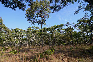
The densely forested Central Zambezian miombo woodlands that cut across southern central Africa are one of the largest ecoregions on the continent and home to a great variety of wildlife, including many large mammals.

The history of rail transport in Zambia began at the start of the twentieth century.
Copper mining in the Democratic Republic of the Congo mainly takes place in the Copper Belt of the southern Katanga Province of the Democratic Republic of the Congo.
The Musonoi mine is a set of open-cut pits near Kolwezi from which copper and other metals have been extracted since the 1940s. The mining complex is located in the Lualaba Province of the Democratic Republic of the Congo. Kolwezi is about 320 kilometres (200 mi) northwest from Lubumbashi, the provincial capital.

The Kambove mines are a group of active or abandoned copper mines near Kambove in the Democratic Republic of the Congo. They were originally established by the Union Minière du Haut-Katanga under Belgian rule.
The Etoile Mine is an open-pit copper mine on the outskirts of Lubumbashi in Katanga Province of the Democratic Republic of the Congo (DRC). Chemaf owns the license. Chemaf is 95% owned by Shalina Resources and 5% by the DRC government.
Nikanor plc was a publicly quoted holding company for Global Enterprises Corporate (GEC) with assets in the rich Copperbelt region in Katanga Province, Democratic Republic of the Congo (DRC).

The Lufilian Arc is part of a system of orogenic belts in southern Africa formed during the Pan-African orogeny, a stage in the formation of the Gondwana supercontinent. It extends across eastern Angola, the Katanga Province of the southern Democratic Republic of the Congo and the northwest of Zambia. The arc is about 800 kilometres (500 mi) long. It has global economic importance owing to its rich deposits of copper and cobalt.
Chambishi is a town in Kalulushi District in the Copperbelt Province of Zambia. According to the 2021 Census its population stands at slightly above 11,000. It is located in the approximate centre of the province, and on the T3 Road between the cities of Kitwe and Chingola.

The geology of the Republic of the Congo, also known as Congo-Brazzaville, to differentiate from the Democratic Republic of the Congo, formerly Zaire, includes extensive igneous and metamorphic basement rock, some up to two billion years old and sedimentary rocks formed within the past 250 million years. Much of the country's geology is hidden by sediments formed in the past 2.5 million years of the Quaternary.

The geology of the Democratic Republic of the Congo is extremely old, on the order of several billion years for many rocks. The country spans the Congo Craton: a stable section of ancient continental crust, deformed and influenced by several different mountain building orogeny events, sedimentation, volcanism and the geologically recent effects of the East Africa Rift System in the east. The country's complicated tectonic past have yielded large deposits of gold, diamonds, coltan and other valuable minerals.

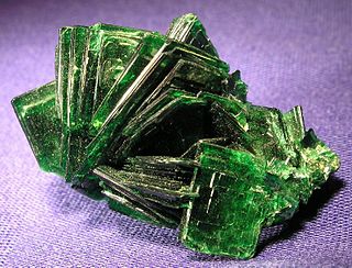
The geological history of Zambia begins in the Proterozoic eon of the Precambrian. The igneous and metamorphic basement rocks tend to be highly metamorphosed and may have formed earlier in the Archean, but heat and pressure has destroyed evidence of earlier conditions. Major sedimentary and metamorphic groups formed in the mid-Proterozoic, followed by a series of glaciations in the Neoproterozoic and much of the Paleozoic which deposited glacial conglomerate as well as other sediments to form the Katanga Supergroup and rift-related Karoo Supergroup. Basalt eruptions blanketed the Karoo Supergroup in the Mesozoic and Zambia shifted to coal and sandstone formation. Geologically recent windblown sands from the Kalahari Desert and alluvial deposits near rivers play an important role in the modern surficial geology of Zambia. The country has extensive natural resources, particularly copper, but also cobalt, emeralds, other gemstones, uranium and coal.

Roan Antelope is a copper mine in Zambia. The deposits were discovered in 1902, but their full extent was not understood until 1926. The mine site was developed between 1927 and 1931, at first experiencing many deaths from malaria due to poor drainage. Production since then has experienced various slumps and booms. The mine was nationalized in 1970 and returned to private ownership in 1997. The new owners struggled to make it profitable, and it changed hands twice.

