
Bilaspur, also known as "The City of Festivals", is a city located in Bilaspur District in the Indian state of Chhattisgarh. Bilaspur is the Administrative headquarters of the Bilaspur District and Bilaspur Division. The Chhattisgarh High Court, located at Bodri, District Bilaspur has privileged it with the title Nyayadhani of the State. This city is the commercial center and business hub of North East Chhattisgarh region. It is also an important city for the Indian Railways, as it is the headquarters for South East Central Railway Zone (SECR) and the Bilaspur Railway Division. Bilaspur is also the headquarters of South Eastern Coalfields Limited. Chhattisgarh biggest power plant operated by NTPC is in Sipat. PowerGrid in Sipat pools electricity from other power plants in region and transmits electricity to Delhi via one of longest HVDC line.

Bilaspur district is a district of the Chhattisgarh state of India. Bilaspur city is the headquarters of the district. As of 2011, it is the second most populous district of Chhattisgarh, after Raipur.
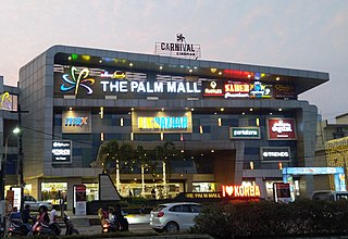
Korba is a city and an industrial area in Korba District in the Indian state of Chhattisgarh. Korba was erstwhile part of Bilaspur District before 25 May 1998 later that Korba was made a separate District for ease of administration but it is still under Bilaspur Division. Korba is called power capital of Chhattisgarh due to its Coal reserves and Industrial base for multiple thermal based power plants from Public sector like NTPC Limited, CSEB from State of Chhattisgarh as well as from private sector apart from Power plants Korba has the Asia's second largest and India's largest open cast coal mine in Gevra area of Korba Coalfield. Korba produces 140 Million tons of coal every year which accounts for 17% of Country's total coal production and 85% of Chhattisgarh Coal production. BALCO Private owned Aluminium producer has its smelter Aluminium Plant in Korba. Here mainly the protected tribal tribe Korwa resides. Korba district is blessed by lush green forests from all around, a large population of tribals is found here. The tribals here prefer to live in harmony with the environment in the forest area due to which they have retained their distinctive cultural characteristics and traditional practices.

Amarkantak is a pilgrim town and a Nagar Panchayat in Anuppur, Madhya Pradesh, India. The Amarkantak region is a unique natural heritage area and is the meeting point of the Vindhya and the Satpura Ranges, with the Maikal Hills being the fulcrum. This is where the Narmada River, the Son River and Johilla River originate.

Janjgir–Champa district is a district in the Indian state of Chhattisgarh. The district headquarters of the district Janjgir–Champa, Janjgir, is the city of Maharaja Jajawalya Dev of the Kalachuri dynasty. Earlier a part of the Bilaspur district, Jangir was carved out in 1998 to a separate district of its own, and ran to a political controversy about the name of the freshly minted district, which it carries to date as the name "Janjgir–Champa". Inhabitants are generally migrants from nearby villages.
Mahasamund is a city in Mahasamund District in the Indian state of Chhattisgarh.It is situated on the Mumbai-Kolkata and Raipur-Vishakhaptnam National Highways. It is one of the largest and most important cities in the State. The city is divided into 30 wards and 5 zones and is also the biggest city in the Trans-Mahanadi area. It is also the administrative headquarters of the Mahasamund District and part of the proposed new Mahasamund Municipal Corporation. The current mayor is Prakash Chandrakar. Reliance Trends, Vishal Megamart, Reliance Jio Smart Point, B mart and Zee Sale are prominent Shopping Centers of the City.

Raigarh is a city in northern Chhattisgarh known as the 'Cultural capital of Chhattisgarh', Raigarh is famous for its dance form “Kathak” and classical music, Raigarh is also known as Sanskardhani.
Dantewada is a town and a municipality, or nagar palika. in the Dantewada district in the state of Chhattisgarh, India.It is the administrative headquarters of Dantewada District. It is the fourth largest city of Bastar division. The town is named after the goddess Danteshwari, the presiding deity of the Danteshwari Temple located in the town, 80 km from the Jagdalpur town. The goddess is worshipped as an incarnation of Shakti and the temple is held to be one of the fifty-two sacred Shakti Peethas. Dantewada Town is well connected by broad gauge railway line from Visakhapatnam. The Nearest Big city to Dantewada is Raipur and well connected with Bus services

Surajpur is a Nagar Palika Parishad situated in the bank of Rihand River in Surajpur district of Chhattisgarh state in Central India. It is the administrative headquarters of the Surajpur district, located 334 km away from the state's capital city, Raipur. The National Highway 43 has its route through Surajpur.
Akaltara is a nagar palika and tehsil in Janjgir-Champa district in the state of Chhattisgarh, India. It is the birthplace of a great freedom fighter Thakur Chhedi Lal (Barrister). Akaltara has a member in legislation assembly of Chhattisgarh state, which is now represented by Mr. Saurabh Singh of the Bhartiya Janta Party. It is under Janjgir Parliament seat, which is represented by Mrs. Kamla Devi Patle.
Baloda Bazar is a nagar palika parishad in Baloda Bazar district in the Indian state of Chhattisgarh. Its PIN code is 493332. On 15 August 2011, it was declared as a district. Baloda Bazar is also called Cement hub of Chhattisgarh because there are many reputed cement plants like Ambuja Cement Rawan, Nuvoco Cement Sonadih, Nu Vista Cement Risda, Shree Cement Khapradih, UltraTech Cement Hirmi, UltraTech Cement Rawan, etc.
Bhatapara is a city and a Nagar Palika (municipality) in the Baloda Bazar-Bhatapara district of the state of Chhattisgarh, India.
Maudaha is a city and a Municipal Board in Hamirpur district, Uttar Pradesh, India.
Nowrozabad or Khodargama is a city and a Nagar Palika in Umaria district in the Indian state of Madhya Pradesh. Kendriya Vidyalaya Nowrozabad is situated in the G.M Complex Johilla area. Nowrozabad is the head office of Johilla area. The nearest Airport is at Jabalpur in Madhya pradesh. Nowrozabad Railway Station is on the Katni - Anuppur rail route. There are many coal mines around here. National Highway 43 has its route through Nowrozabad.

Ratanpur was historical capital of Chhattisgarh until British takeover of Central Province from Maratha. Ratanpur is a town and a nagar palika in Bilaspur district in the Indian state of Chhattisgarh. It is located about 25 kilometres (16 mi) from Bilaspur on National Highway 130 towards Ambikapur.
Tilda-Neora is a small town and a municipality and a Tehsil Block in the outskirts of Raipur City in the Indian state of Chhattisgarh.

Mahasamund district is a district in Chhattisgarh state in central India. The city of Mahasamund is the district headquarters. The district is particularly famous for the historical temple town of Sirpur besides the Mahanadi river.

Janjgir is the headquarters of the Janjgir–Champa district in Chhattisgarh, India. It has been the district headquarters since 25 May 1998, when Janjgir–Champa was carved out of Bilaspur. Well known for its Vishnu Temple aka Nakta Mandir, Janjgir is undergoing rapid industrial development and will become home to various thermal power plants in the coming years. After several attempts made by the people to adopt the name Janjgir, the railway station name changed from Naila to Janjgir-Naila. Janjgir is well connected by railways and roads and is connected to major cities like Bilaspur and Raipur through National Highway 200.
Pandatarai is a town & nagar panchayat in the Kabirdham district of Chhattisgarh, India. This is a religious and tourist site. In Pandatarai temple of Maa Mahamaya (durga) and a historical temple of lord Shivajaleshwar mahadev dongariya is near about Pandatarai and dargahe auliya sher shah vali are most popular places. Dongariya mahadev is also papular destination Pandatarai Pin code is 491559 and postal head office is Pandaria.

Gaurela-Pendra-Marwahi district is a district in the Indian state of Chhattisgarh. Gaurella is the headquarters of the district. It was carved out of Bilaspur district and inaugurated in February 2020.

