Megalopoli is a town in the southwestern part of the regional unit of Arcadia, southern Greece. It is located in the same site as ancient Megalopolis (Μεγαλόπολις). When it was founded in 371 BC, it was the first large urbanization in rustic Arcadia. Its theater had a capacity of 20,000 visitors, making it one of the largest ancient Greek theaters. Megalopoli has several schools, shops, churches, hotels and other services. The population of Megalopoli in 2011 was 5,779 for the town proper.
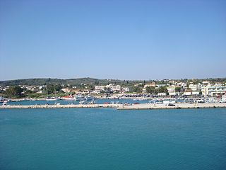
Kastro-Kyllini is a former municipality in Elis, West Greece, Greece. Since the 2011 local government reform it is part of the municipality Andravida-Kyllini, of which it is a municipal unit. The municipal unit has an area of 49.322 km2. The population was 3,622 in 2011. The municipality Kastro-Kyllini was created in 1999 as part of the Kapodistrias reform from the formerly independent communities Kyllini, Kato Panagia, Kastro and Neochori, that became municipal districts. After the 2011 Kallikratis reform, these municipal districts became (dependent) communities. Its seat of administration was the small port town of Kyllini.

Rio is a town in the suburbs of Patras and a former municipality in Achaea, West Greece, Greece. Since the 2011 local government reform it is part of the municipality Patras, of which it is a municipal unit. The municipal unit has an area of 98.983 km2. The municipal unit had a population of 14,622 in 2011. The campus of the University of Patras and the Casino Rio is located in Rio.
Anavryto is a mountain village and a community in the municipal unit Falaisia, Arcadia, Greece. The community consists of the villages Anavryto and Kato Anavryto, 1 km south of Anavryto. Both villages are on the southwestern slope of mount Tsemperou. Anavryto is 3 km southeast of Anemodouri, 3 km northeast of Voutsaras and 11 km southeast of Megalopoli. The village has a school and a church named Agia Marina. Anavryto suffered damage from the 2007 Greek forest fires.
Limnochori is a village and a community in the municipal unit of Movri in Achaea, Greece. The community consists of the villages Limnochori, Kalamaki, Kato Limnochori and Paralia Kalamakiou. It is located in the plains near the Gulf of Patras. It is 4 km north of Sageika, 4 km southeast of Lakkopetra, 6 km west of Kato Achaia and 4 km east of Araxos Airport.

Kalavryta is a town and a municipality in the mountainous east-central part of the regional unit of Achaea, Greece. The town is located on the right bank of the river Vouraikos, 24 kilometres south of Aigio, 40 km southeast of Patras and 62 km northwest of Tripoli. Notable mountains in the municipality are Mount Erymanthos in the west and Aroania or Chelmos in the southeast. Kalavryta is the southern terminus of the Diakopto-Kalavryta rack railway, built by Italian engineers between 1885 and 1895.
Varvasaina is a village and a community in the eastern part of the municipality of Pyrgos, Elis, Greece. The community consists of the villages Varvasaina and Kato Varvasaina. It is situated in a valley between low hills, 3 km southeast of Koliri, 3 km northwest of Salmoni, 5 km north of Epitalio and 5 km east of Pyrgos town centre. The Greek National Road 74 passes south of the village. The railway from Pyrgos to Kalamata and Olympia passes through Kato Varvasaina.
Kato Kastritsi is a village and a community in the municipal unit of Rio, Achaea, Greece. The community consists of the villages Kato Kastritsi and Magoula. It is situated at about 100 m elevation in the northwestern foothills of the Panachaiko, 2 km southeast of Rio town centre, and adjacent to the campus of the University of Patras. Ano Kastritsi is 4 km to the southeast.
Falaisia is a village and a former municipality in southwestern Arcadia, Peloponnese, Greece. Since the 2011 local government reform it is part of the municipality Megalopoli, of which it is a municipal unit. The municipal unit has an area of 274.926 km2. The seat of the municipality was in Leontari, 5 km northwest of the village Falaisia. The municipal unit Falaisia is located in the northern foothills of the Taygetus mountains, south of Megalopoli and north of Kalamata. It borders on Laconia to the southeast, and Messenia to the southwest.
Melivoia is a town and a former municipality in the Larissa regional unit, Thessaly, Greece. Since the 2011 local government reform it is part of the municipality Agia, of which it is a municipal unit. Population 2,195 (2011). The municipal unit has an area of 197.633 km2. The seat of the municipality was in Kato Sotiritsa. Melivoia is located east of Larissa, the capital of the regional unit and Thessaly, and a few kilometers north of Agia. The municipal unit stretches along the Aegean Sea coast, at the foot of Mount Ossa. It was named after the ancient city Meliboea. The municipal unit borders on Magnesia to the southeast.
Kato Vlasia is a mountain village and a community in the municipality of Kalavryta, Achaea, Greece. The community consists of the villages Kato Vlasia, Menychtaiika and Metochi. It is situated at about 800 m elevation. near the source of the river Selinountas, east of the highest summit of Mount Erymanthos. It is 1 km north of Ano Vlasia, 16 km southeast of Chalandritsa and 17 km west of Kalavryta.
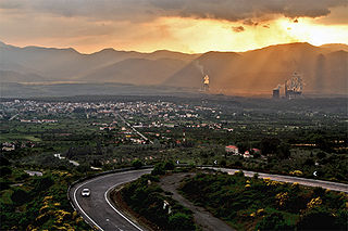
Thoknia is a village in the municipality of Megalopoli, Arcadia, Greece. It is situated near the confluence of the rivers Alfeios and Elissonas, at about 360 m elevation. It was named after the ancient Arcadian city Thocnia, that was located in the area. Thoknia is 2 km east of Kato Karyes, 3 km southeast of Kyparissia, 3 km southwest of Plaka and 5 km northwest of Megalopoli. Thoknia had a population of 36 in 2011. The village is surrounded by open-pit lignite mines.
Kato Karyes is a village in the municipality of Megalopoli, Arcadia, Greece. It is situated near the left bank of the river Alfeios. It is 2 km southeast of Isoma Karyon, 2 km west of Thoknia and 7 km northwest of Megalopoli. Kato Karyes had a population of 61 people according to the 2011 census. There is a power plant and several open-pit lignite mines east of the village.
Gavalou is a town and a community in the municipal unit of Makryneia, Aetolia-Acarnania, Greece. In 2011 its population was 1,018 for the town, and 1,051 for the community, which includes the small village Kourtelaiika. The town is located south of Lake Trichonida, the largest natural lake of Greece. It is 7 km east of Papadates, 10 km northwest of Kato Makrinou and 15 km southeast of Agrinio.
Petrochori is a village in Achaea, Greece. It is part of the municipality of West Achaea. It is located 6 km south of Kato Achaia, and 25 km southeast of Patras. The population of Petrochori in 2001 was 177 for the village and 721 for the community, which consists of the villages Petrochori, Karya, Lampraiika, Logothetis, Veskoukaiika, Vythoulkas and Zampeteika. The nearest villages are Ano Achaia to the northeast and Elaiochori to the east.
Agiovlasitika is a village in Achaea, Greece. Agiovlasitika is in the municipality of West Achaea. It is located about 3 km southeast of Kato Achaia, and 20 km southwest of Patras. The river Peiros flows northeast of the village. Its population in 2011 was 84 for the village and 241 for the community, which consists of the villages Agiovlasitika, Kapeli, Lefkos and Stenaitika.
Giannaioi is a community of the municipal unit of Falaisia in Arcadia, Peloponnese, Greece. It consists of the two mountain villages Ano Giannaioi and Kato Giannaioi. Ano Giannaioi is 1 km southeast of Kato Giannaioi. Both villages are situated on a mountain slope, in the northern foothills of the Taygetus mountains, between 600 and 700 m elevation. Kato Giannaioi is 1 km south of Kamara, 5 km north of Dyrrachio, 11 km southeast of Leontari and 19 km south of Megalopoli.
Kato Samiko is a village and a community in the municipal unit of Skillounta, Elis, Greece. It is situated 2 km from the Ionian Sea, 3 km southeast of Samiko, 6 km southwest of Krestena, 8 km northwest of Zacharo and 20 km southeast of Pyrgos. Its population in 2011 was 428 for the village and 494 for the community, which includes the small villages Kleidi and Fragkokklisia. The Greek National Road 9 and the railway from Pyrgos to Kalamata run through the village. Kato Samiko suffered damage from the 2007 Greek forest fires. The ruins of ancient Samicum lie within the borders of the municipal unit.

