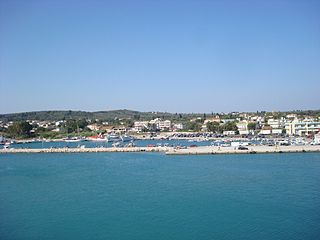
Kastro-Kyllini is a former municipality in Elis, West Greece, Greece. Since the 2011 local government reform it is part of the municipality Andravida-Kyllini, of which it is a municipal unit. The municipal unit has an area of 49.322 km2. The population was 3,272 in 2021. The municipality Kastro-Kyllini was created in 1999 as part of the Kapodistrias reform from the formerly independent communities Kyllini, Kato Panagia, Kastro and Neochori, that became municipal districts. After the 2011 Kallikratis reform, these municipal districts became (dependent) communities. Its seat of administration was the small port town of Kyllini.
Kourtesi is a village and a community in the southwestern part of the municipal unit of Vouprasia, Elis, Greece. It is in a flat rural area, southeast of the Kotychi lagoon, 7 km southwest of Varda in the northeast, 1 km east of Areti and 7 km northeast of Lechaina. Kourtesi lies on the Greek National Road 9 connecting Patras and Pyrgos, and on the railway from Patras to Pyrgos. The community consists of the villages Kourtesi, Ano Kourtesi and Kotteika. The smaller villages Ano Kourtesi and Kotteika lie to the southeast of Kourtesi.
Anavryto is a mountain village and a community in the municipal unit Falaisia, Arcadia, Greece. The community consists of the villages Anavryto and Kato Anavryto, 1 km south of Anavryto. Both villages are on the southwestern slope of mount Tsemperou. Anavryto is 3 km southeast of Anemodouri, 3 km northeast of Voutsaras and 11 km southeast of Megalopoli. The village has a school and a church named Agia Marina. Anavryto suffered damage from the 2007 Greek forest fires.
Souli is a village and a community in the municipality of Megalopoli in southwestern Arcadia, Greece. The community consists of the mountain villages Souli and Derveni. Both villages are located in the mountains on the border with Messenia, at about 500 m elevation. Derveni is on the old road from Megalopoli to Kalamata, and Souli is 1 km southeast of it. Souli is 2 km west of Chirades, 4 km southwest of Paradeisia, 15 km southwest of Megalopoli and 30 km north of Kalamata. Souli suffered damage from the 2007 Greek forest fires.
Kato Kastritsi is a village and a community in the municipal unit of Rio, Achaea, Greece. The community consists of the villages Kato Kastritsi and Magoula. It is situated at about 100 m elevation in the northwestern foothills of the Panachaiko, 2 km southeast of Rio town centre, and adjacent to the campus of the University of Patras. Ano Kastritsi is 4 km to the southeast.
Vlachata is a village and a community in the eastern part of the municipal unit of Leivatho near the south coast of the island of Kefalonia, Greece. To avoid confusion with another Vlachata near Sami, it is also known as Vlachata Eikosimias. The community consists of the villages Vlachata and Simotata, which is 2 km east of Vlachata. Vlachata is situated on a mountain slope above the Ionian Sea coast, at about 200 m elevation. Mount Ainos, the highest point of Cephalonia, is 4 km to the northeast. Vlachata is 1 km northwest of Lourdata, 2 km southeast of Mousata, 13 km southwest of Poros and 13 km southeast of Argostoli. The road from Argostoli to Poros runs through Vlachata. Vlachata suffered great damage from the 1953 Ionian earthquake.
Petroto is a village and a community in the municipal unit of Messatida, Patras, Achaea, Greece. The community consists of the villages Petroto, Mavromandila and Agia Paraskevi. Mavromandila is by far the largest village of the community. Mavromandila is located 6 km southeast of Patras city centre, just outside the Patras beltway. The small mountain villages Petroto and Agia Paraskevi are located resp. 5 and 9 km southeast from Mavromandila, to the east and southeast of Omplos mountain. The renowned Achaia Clauss winery is situated in Mavromandila.
Varda is a town and a community in the municipal unit of Vouprasia, Elis, Greece. It was the seat of the former municipality Vouprasia. The community Varda consists of the town Varda and the villages Kougaiika, Komi, Sympanio and Psari. Varda is situated in the plains near the Ionian Sea, and east of the Kotychi lagoon. It is 2 km southeast of Manolada, 3 km southwest of Nea Manolada, 14 km northeast of Lechaina and 40 km southwest of Patras. The railway from Patras to Pyrgos passes west of the town, and the Greek National Road 9 passes east of the town.

Makryneia is a former municipality in Aetolia-Acarnania, West Greece, Greece. Since the 2011 local government reform it is part of the municipality Agrinio, of which it is a municipal unit. The municipal unit has an area of 149.687 km2. The seat of the municipality was in Gavalou. The municipal unit is located south and southeast of Lake Trichonida, and northwest of the mountain Arakynthos. There are farmlands near the lake shore, and forests on the mountain slopes. Makryneia is southeast of Agrinio, northeast of Missolonghi and northwest of Naupactus.
Gavalou is a town and a community in the municipal unit of Makryneia, Aetolia-Acarnania, Greece. The community includes the small village Kourtelaiika. The town is located south of Lake Trichonida, the largest natural lake of Greece. It is 7 km east of Papadates, 10 km northwest of Kato Makrinou and 15 km southeast of Agrinio.
Kato Makrinou is a village in the municipal unit of Makryneia, Aetolia-Acarnania, Greece. It is located in a valley southeast of Lake Trichonida. It is 2 km northeast of Makrinou, 10 km southeast of Gavalou and 20 km northwest of Naupactus.
Trilofo is a village and a community in the municipality of Megalopoli, Arcadia, Greece. It is situated in the southwestern foothills of the Mainalo mountains, at about 550 m elevation. It is 2 km northeast of Nea Ekklisoula, 3 km southeast of Zoni, 3 km southwest of Karatoulas and 6 km north of Megalopoli. The community includes the village Palaiomoiri.
Petrina is a village and a community in the municipal unit of Falaisia, Arcadia, Greece. It is situated in the northern foothills of the Taygetus mountains. It is 3 km east of Falaisia, 4 km west of Skortsinos, 4 km south of Voutsaras, 7 km southeast of Leontari and 14 km southeast of Megalopoli. The community includes the village Spanaiika.
Kotylio is a village and a community in the municipal unit Gortyna, southwest Arcadia, Greece. It is situated on the northeastern slope of Mount Lykaion on a height of ca. 900 m, 3 km from the border with Elis. It is 4 km west of Karytaina, 6 km southeast of Theisoa, 8 km east of Andritsaina and 15 km northwest of Megalopoli. The community includes the small villages Palatos and Strongylo.
Syrna is a mountain village and a community in the municipal unit of Trikolonoi, western Arcadia, Greece. Syrna is situated on a mountain slope above the right bank of the river Alfeios, at about 800 m elevation. In 2011 Syrna had a population of 60 for the village and 62 for the community, which includes the village Ano Kalyvia. Syrna is 2 km northwest of Palamari, 4 km southeast of Elliniko, 6 km northeast of Karytaina and 6 km southeast of Stemnitsa.
Dafni is a village and a community in the municipal unit of Valtetsi, Arcadia, Greece. The community includes the village Maniatis. Dafni is situated in a plain at the northeastern foot of the Tsemperou mountain. It is 2 km (1 mi) southeast of Paparis, 7 km (4 mi) south of Asea, 14 km (9 mi) southeast of Megalopoli and 19 km (12 mi) southwest of Tripoli.
Giannaioi is a community of the municipal unit of Falaisia in Arcadia, Peloponnese, Greece. It consists of the two mountain villages Ano Giannaioi and Kato Giannaioi. Ano Giannaioi is 1 km southeast of Kato Giannaioi. Both villages are situated on a mountain slope, in the northern foothills of the Taygetus mountains, between 600 and 700 m elevation. Kato Giannaioi is 1 km south of Kamara, 5 km north of Dyrrachio, 11 km southeast of Leontari and 19 km south of Megalopoli.
Kato Samiko is a village and a community in the municipal unit of Skillounta, Elis, Greece. It is situated 2 km from the Ionian Sea, 3 km southeast of Samiko, 6 km southwest of Krestena, 8 km northwest of Zacharo and 20 km southeast of Pyrgos. The community includes the small villages Kleidi and Fragkokklisia. The Greek National Road 9 and the railway from Pyrgos to Kalamata run through the village. Kato Samiko suffered damage from the 2007 Greek forest fires. The ruins of ancient Samicum lie within the borders of the municipal unit.
Ampelokipoi is a village and a local community in the southern part of the island of Zakynthos. It is part of the municipal unit of Zakynthos (city). The community includes the village Kalpaki. It is 3 km northwest of Kalamaki, 4 km north of Laganas and 3 km southwest of Zakynthos city. The Zakynthos International Airport is 1 km southeast.
Prasino is a village and a community in the municipal unit of Iardanos, Elis, Greece. It is 2 km northwest of Agios Georgios, 3 km southeast of Vounargo and 5 km northwest of Pyrgos town centre. The community consists of the villages Prasino, Glykorizo and Keramidia. Its elevation is 70 m.
