
The Wright Valley is a large east–west trending valley, formerly occupied by a glacier but now ice free except for Wright Upper Glacier at its head and Wright Lower Glacier at its mouth, in Victoria Land, Antarctica. It was named by the VUWAE (1958-59) for Sir Charles Wright, for whom the BrAE (1910-13) named the glacier at the mouth of this valley.
Pedro Bank is a large bank of sand and coral, partially covered with seagrass, about 80 km south and south-west of Jamaica, rising steeply from a seabed of 800 m depth.
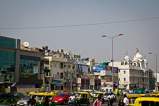
Sri Aurobindo Marg or Aurobindo Marg, is an important South Delhi north-south arterial road connecting historic Safdarjung's Tomb to Qutab Minar. The road is named for Sri Aurobindo Ghosh; the Delhi campus of Sri Aurobindo Ashram is located on the road. The road was originally known as Mehrauli Road.
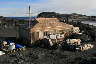
Cape Royds is a dark rock cape forming the western extremity of Ross Island, facing on McMurdo Sound, Antarctica. It was discovered by the British National Antarctic Expedition (BrNAE) (1901–1904) and named for Lieutenant Charles Royds, Royal Navy, who acted as meteorologist on the expedition. Royds subsequently rose to become an Admiral and was later Commissioner of the Metropolitan Police, London. The cape is the site of Shackleton's Hut, the expedition camp of the British Antarctic Expedition, 1907–09.
Santibáñez el Alto is a municipality located in the province of Cáceres, Extremadura, Spain. According to the 2006 census (INE), the municipality has a population of 480 inhabitants.
Karol Bagh Lok Sabha constituency was a Lok Sabha (parliamentary) constituency in the Indian National Capital Territory of Delhi. This constituency came into existence in 1961. It was abolished after the recommendations of the Delimitation Commission were approved by the presidential notification on 19 February 2008. This constituency was reserved for the candidates belonging to the scheduled castes.

Savković is a village in Serbia. It is situated in the Ljubovija municipality, in the Mačva District of Central Serbia. The village had a Serb ethnic majority and a population of 321 in 2002.

The Centre for the Study of Developing Societies (CSDS) is an Indian research institute for social sciences and humanities. It was founded in 1963 by Rajni Kothari and is largely funded by the Indian Council of Social Science Research. It is located in New Delhi, close to Delhi University.
Jia Sarai is an urban village in the south of New Delhi. It is one of the three villages, along with Ber Sarai and Katwaria Sarai, bordering the Indian Institute of Technology Delhi campus. Bhai Trilochan Singh Panesar, also known as Veerji belonged to this village.

Zalakomár is a village in Zala County, Hungary.
Kaatermu is a village in Alutaguse Parish, Ida-Viru County in northeastern Estonia.

Tuksi is a village in Lääne-Nigula Parish, Lääne County, in western Estonia.
Abhaypura is a village in Nawa tehsil of Didwana Kuchaman District of Rajasthan state in India, named after Maharaja Abhay Singh of Marwar. It was one of the 40 villages in the Princely State Abhaypura which was half of Maroth state and was founded around 1683 AD by Maharaja Bijay Singh, third son of Maharaja Raghunath Singh Mertia of Panch Mahal Maroth. Later, after a treaty in 1820 AD it became a Thikana of Marwar and is now called as Thikana Jiliya and has 14 villages, as the rest of the villages were given as appanages or jagirs to younger brothers.
Jarmenovci is a village in the municipality of Topola, Serbia. According to the 2002 census, the village has a population of 563 people.
Gambhirban is a small village in Rani Ki Sarai block, Azamgarh district, Uttar Pradesh, India. It is located about 10 kilometres (6.2 mi) from the city of Azamgarh, near a large pond called Baraila Taal. It is situated near the village of Kanaila Chakrapanipur, home of Rahul Sankrityayan, a Hindi/Sanskrit scholar.
The Syro-Malankara Catholic Eparchy of Gurgaon was established by Pope Francis on 26 March 2015. This diocese has a huge territory in north India, including 22 of the 29 states of India. At the southern boundary of the diocese are the states of Gujarat, Madhya Pradesh, Chhattisgarh and Orissa. The bishop's residence and chancery is at the Mar Ivanios Bhavan in Neb Sarai.
Sarai Jagannath is a village located roughly 1 km south of Bilsuri. It is Gram Panchayat in Sikandrabad Block, Sikandrabad Tehsil in Bulandshahr District of the Indian state of Uttar Pradesh.

Sarai Chhatardhari is a village in Shivgarh block of Rae Bareli district, Uttar Pradesh, India. As of 2011, its population is 1,932, in 351 households. It has one primary school and no healthcare facilities.

Sarai Umar is a village in Harchandpur block of Rae Bareli district, Uttar Pradesh, India. As of 2011, its population is 2,434, in 490 households. It has two primary schools and no healthcare facilities.