
The Tumucumaque Mountains National Park is situated in the Amazon Rainforest in the Brazilian states of Amapá and Pará. It is bordered to the north by French Guiana and Suriname.

The Guiana Shield is one of the three cratons of the South American Plate. It is a 1.7 billion-year-old Precambrian geological formation in northeast South America that forms a portion of the northern coast. The higher elevations on the shield are called the Guiana Highlands, which is where the table-like mountains called tepuis are found. The Guiana Highlands are also the source of some of the world's most well-known waterfalls such as Angel Falls, Kaieteur Falls and Kuquenan Falls.

The agami heron is a medium-sized heron. It is a resident breeding bird from Central America south to Peru and Brazil. It is sometimes known as the chestnut-bellied heron, and is the only member of the genus Agamia. In Brazil it is sometimes called Soco beija-flor, meaning 'hummingbird heron', thanks to its unique coloration pattern.

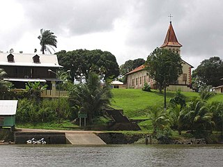
Régina is a commune of French Guiana, an overseas region and department of France located in South America. With a land area of 12,130 km2 (4,680 sq mi), it is the second-largest commune of France. The town is named after the first merchant who settled in the area.

The arrondissement of Cayenne is an arrondissement of France in French Guiana department in French Guiana region. It has 14 communes. Its population is 176,357 (2016), and its area is 42,589 km2 (16,444 sq mi). It is the larger of the two arrondissements in French Guiana.
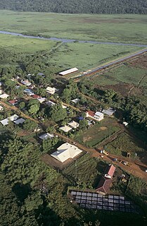
Kaw or Caux is a village in the commune of Régina, in north-east French Guiana, situated on the banks of Approuague river. This is also a very swampy area.
The following is a list of the 19 former cantons of the French Guiana department, an overseas department of France, sorted by arrondissement. The cantons were abolished in 2015, when the Assembly of French Guiana replaced the General Council of French Guiana and the Regional Council of French Guiana.

Matoury is a commune of French Guiana, an overseas region and department of France located in South America.
Roura is a commune of French Guiana, an overseas region and department of France located in South America. The city of Roura is bordered by Matoury and Montsinéry-Tonnegrande in the North, Kourou and Saint-Elie in the North West and West, and finally by Régina in the South and East.

The Waki is a river in western French Guiana. It is a right tributary of the Tampok. It is 147 km (91 mi) long. The river has its source as the confluence of the southern Grande Waki which has its source in the Arawa Mountains, and the northern Petite Waki which has its source in the Sommet Tabulaire.

Articles related to the French overseas department of Guiana(Région Guyane) include:

French Guiana is an overseas department/region and single territorial collectivity of France on the northern Atlantic coast of South America in the Guianas. It borders Brazil to the east and south and Suriname to the west.

La Trinité National Nature Reserve is a French nature reserve in French Guiana created in 1996. It protects 760 square kilometres (290 sq mi) of tropical rainforest in the communes of Mana and Saint-Élie.

Nouragues Nature Reserve is a French nature reserve in French Guiana created in 1995. It protects 1,000 square kilometres (390 sq mi) of tropical rainforest in the communes of Régina and Roura.
A national nature reserve, in French réserve naturelle nationale, (RNN) is a protected area that is part of natural reserves of France (RNF) and whose status is defined by the law on local democracy of February 27, 2002. It is a tool for the long-term protection of spaces, species or geological objects. The duration of its protection is unlimited.

The Mont Grand Matoury Nature Reserve is a nature reserve in French Guiana, France. The reserve is located about eight kilometres south of Cayenne in the commune of Matoury It has been named after the eponymous mountain which measures 234 metres, It was first protected in 1942, and extended in 2006.

The Kaw-Roura Marshland Nature Reserve is a nature reserve in French Guiana, France. The reserve is a wetland, and can only be accessed by boat from Kaw.

The Trésor Regional Nature Reserve is a regional nature reserve in French Guiana, France. The reserve is adjacent to the national Kaw-Roura Marshland Nature Reserve on the flank of the Kaw Mountain. The reserve is located about 20 kilometres from Roura.

Cottica Mountain is a 744 metres high mountain near the Maroni River in the commune of Papaichton in French Guiana, France.

