
Mbale is a city in the Eastern Region of Uganda. It is the main municipal, administrative, and commercial center of Mbale District and the surrounding sub-region.
Masaka is a district and a city in the Buganda Region in southern Uganda, west of Lake Victoria. The city is the headquarters of Masaka District.
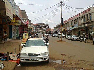
Sembabule is a town in Sembabule District in the Central Region of Uganda. The town is the main municipal, administrative, and commercial center of the district and the site of the district headquarters.
Mpigi is a town in Mawokota County, Mpigi District, in Central Uganda. Mpigi is the municipal, administrative and commercial headquarters of Mpigi District. The district is named after the town.

Uganda Martyrs University (UMU) is a private University affiliated with the Roman Catholic Church in Uganda. The University is owned by the Episcopal Conference of the Catholic Bishops of Uganda. It is licensed by the Uganda National Council for Higher Education. UMU consists of seven Faculties, two Institute, six Campuses, nine Departments, and three schools. As of March 2022, total student enrollment is 4,632. Of these, about 1,500 students were residential, while nearly 3,000 students were enrolled in UMU's distance learning programs. The number of staff members was over 400.
Nsangi is a town in the Central Region of Uganda. It is one of the urban centers in Wakiso District.
Busega is a neighborhood within Kampala, Uganda's capital and largest city.
Nkozi is a town in central Uganda. It is one of the urban centers in Mpigi District.
Nkozi Hospital is a hospital in Nkozi, Mpigi District, in the Central Region of Uganda. It is a private, non-profit, community hospital, serving the town of Nkozi and surrounding areas of southern Mawokota County. The hospital also serves as the nearest and hospital of first choice for the staff and students of Uganda Martyrs University, located in the same town.
Kanoni, also Kanoni, Gomba or Kanoni–Gomba, is a town in the Central Region of Uganda. It is the commercial, administrative, and political headquarters of Gomba District.
Namataba is a town in Mukono District, Central Uganda. The town is an urban center under Mukono District Administration.
Mpigi–Kabulasoke–Maddu–Sembabule Road is a road in the Central Region of Uganda, connecting the towns of Mpigi in Mpigi District to Gombe in Butambala District, Kabulasoke and Maddu in Gomba District and Sembabule in Sembabule District.
Kabulasoke is a town in Gomba District in the Central Region of Uganda.
The Kampala–Mpigi Expressway, also Busega–Mpigi Expressway, is a four-lane, dual carriage highway under construction in the Central Region of Uganda, connecting, Kampala, the capital city, and Mpigi, the headquarters of Mpigi District.
The Kampala–Masaka Road is a road in the Central Region of Uganda, connecting the capital city of Kampala to the southwestern town of Masaka in Masaka District. The first 36 kilometres (22 mi) of this road, is in the process of being developed into the Kampala–Mpigi Expressway.
Maya is a town in the Central Region of Uganda. It is one of the urban centers in Wakiso District.
Lwensinga is a town in the Buganda Region of Uganda.
Buwama is a town in the Buganda Region of Uganda.
Nabbingo is a hill in Wakiso District in the Buganda Region of Uganda. The hill rises 1,178 metres (3,865 ft) above sea level. The name "Nabbingo", also applies to the village that occupies the hill and the schools and churches that are located there.
The Nakawuka–Kasanje–Mpigi Road, is a road in the Central Region of Uganda, connecting the towns of Nakawuka and Kasanje in Wakiso District to the city of Mpigi, the district capital of Mpigi District. When completed, the road is expected to ease travel between the city of Entebbe and Mpigi, Masaka and communities in the Western Region of Uganda. The road bypasses the road traffic congestion around Kampala, the national capital.

