
Gunnison County is a county located in the U.S. state of Colorado. As of the 2020 census, the population was 16,918. The county seat is Gunnison. The county was named for John W. Gunnison, a United States Army officer and captain in the Army Topographical Engineers, who surveyed for the transcontinental railroad in 1853.

Salida is the statutory city that is the county seat and the most populous municipality of Chaffee County, Colorado, United States. The population was 5,666 at the 2020 census.

Crested Butte is a home rule municipality located in Gunnison County, Colorado, United States. The town population was 1,639 at the 2020 United States Census. A former coal mining town nestled in the Slate River Valley, Crested Butte is now known as a destination for skiing, mountain biking, and outdoor activities.

Gunnison is a home rule municipality that is the county seat and the most populous municipality of Gunnison County, Colorado. The city population was 6,560 at the 2020 United States Census. The city was named in honor of John W. Gunnison, a United States Army officer who surveyed for a transcontinental railroad in 1853.

Mt. Crested Butte is a home rule municipality in Gunnison County, Colorado, United States. Mount Crested Butte is the home of the Crested Butte Mountain Resort. The population was 941 at the 2020 census. ZIP code 81225 serves post office boxes for Mount Crested Butte and for neighboring Crested Butte; mail must be addressed to Crested Butte.

The Elk Mountains are a high, rugged mountain range in the Rocky Mountains of west-central Colorado in the United States. The mountains sit on the western side of the Continental Divide, largely in southern Pitkin and northern Gunnison counties, in the area southwest of Aspen, south of the Roaring Fork River valley, and east of the Crystal River. The range sits west of the Sawatch Range and northeast of the West Elk Mountains. Much of the range is located within the White River National Forest and the Gunnison National Forest, as well as the Maroon Bells-Snowmass Wilderness and Raggeds Wilderness. The Elk Mountains rise nearly 9,000 ft. above the Roaring Fork Valley to the north.
Schofield Pass, elevation 10,707 ft (3,263 m), is a mountain pass in the Elk Mountains of Colorado. The pass is the high point on Gothic Road, which connects the towns of Marble and Crested Butte. The pass is closed for most of the year due to snow or mud, and is open only for one or two months in late summer.

Crystal is a ghost town on the upper Crystal River in Gunnison County, Colorado, United States. It is located in the Elk Mountains along a four-wheel-drive road 6 miles (9.7 km) east of Marble and 20 miles (32 km) northwest of Crested Butte. Crystal was a mining camp established in 1881 and after several decades of robust existence, was all but abandoned by 1917. The Crystal post office operated from July 28, 1882, until October 31, 1909. Many buildings still stand in Crystal, but its few residents live there only in the summer.
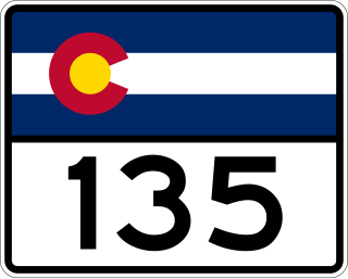
State Highway 135 (SH 135) is a 27.48-mile-long (44.22 km) state highway in the U.S. state of Colorado. SH 135's southern terminus is at U.S. Route 50 (US 50) in Gunnison, and the northern terminus is at 6th Street in Crested Butte. It is the primary connection between Crested Butte and the outside world and is the only paved road leading to Crested Butte.

Almont is an unincorporated community and U.S. Post Office in Gunnison County, Colorado, United States. The ZIP Code of the Almont Post Office is 81210.

State Highway 133 (SH 133) is a 71.4 mi (114.9 km) long north–south byway connecting SH 92 to the south and SH 82 to the north, and travels through the towns of Hotchkiss, Somerset, Redstone, and Carbondale. Highway 133 travels over a significant mountain pass on the northern end, called McClure Pass, which is 8,755 ft (2,669 m) above sea level. The road travels right next to the Crystal River, known for whitewater river running.

Crested Butte is a prominent mountain summit in the Elk Mountains range of the Rocky Mountains of North America. The 12,168-foot (3,709 m) peak is in Gunnison National Forest, 2.1 miles (3.4 km) northeast by east of the Town of Crested Butte in Gunnison County, Colorado, United States. Ski lifts and runs of the Crested Butte Mountain Resort occupy the north side of the mountain.

Crested Butte Mountain Resort is a ski resort at Mount Crested Butte in Gunnison County, Colorado, United States.

Cottonwood Pass is a high mountain pass on the Continental Divide in south-central Colorado in the Rocky Mountains of the western United States. It is located along the border of Gunnison and Chaffee counties in Colorado, and is in the Sawatch Range. The road over Cottonwood Pass is the highest paved crossing of the Continental Divide in the U.S., and the second highest pass with an improved road in the state. It is the fourth-highest paved road in the state after Mount Blue Sky Scenic Byway, Pikes Peak Highway, and Trail Ridge Road.

Slate River is a 23.7-mile-long (38.1 km) tributary of the East River in Gunnison County, Colorado, United States. It flows south from a source near Yule Pass in the Raggeds Wilderness to a confluence with the East River southeast of Crested Butte, Colorado.
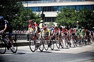
The 2011 USA Pro Cycling Challenge was the inaugural edition of the USA Pro Cycling Challenge stage race. The race was held from August 22–28, and was rated as a 2.1 event on the UCI America Tour. The race began with a short prologue time trial in Colorado Springs, wound its way through the Rocky Mountains at heights of up to 12,000 feet (3,700 m), and finished in the streets of downtown Denver.

East Beckwith Mountain is a prominent mountain summit in the West Elk Mountains range of the Rocky Mountains of North America. The 12,441-foot (3,792 m) peak is located in the West Elk Wilderness of Gunnison National Forest, 13.4 miles (21.5 km) west by south of the Town of Crested Butte in Gunnison County, Colorado, United States.

West Beckwith Mountain is a prominent mountain summit in the West Elk Mountains range of the Rocky Mountains of North America. The 12,185-foot (3,714 m) peak is located in the West Elk Wilderness of Gunnison National Forest, about 16.5 miles (26.5 km) southwest of Crested Butte in Gunnison County, Colorado, United States.

Colorado's 5th Senate district is one of 35 districts in the Colorado Senate. It has been represented by Republican Perry Will since 2023 following the resignation of fellow Republican Bob Rankin. Prior to redistricting the district was represented by Democrats Kerry Donovan and Gail Schwartz.

The West Elk Loop Scenic and Historic Byway is a 205-mile (330 km) National Forest Scenic Byway and Colorado Scenic and Historic Byway located in Delta, Garfield, Gunnison, Montrose, and Pitkin counties Colorado, USA. The byway reaches its zenith at Kebler Pass, elevation 10,007 feet (3,050 m), between Crested Butte and Paonia.

