
Sangiran is an archaeological excavation site in Java in Indonesia. According to a UNESCO report (1995) "Sangiran is recognized by scientists to be one of the most important sites in the world for studying fossil man, ranking alongside Zhoukoudian (China), Willandra Lakes (Australia), Olduvai Gorge (Tanzania), and Sterkfontein, and more fruitful in finds than any of these."

Cilacap Regency is a regency in the southwestern part of Central Java province in Indonesia. Its capital is the town of Cilacap.

Jombang Regency is a regency of East Java, Indonesia, situated to the southwest of Surabaya. The capital of the regency is the town of Jombang. The regency has an area of 1,159.50 km2 and a population of 1,202,407 at the 2010 census and 1,318,062 at the 2020 census; the official estimate as of mid-2023 was 1,370,510. It became a regency in 1910. It was the birthplace of Abdurrahman Wahid, the 4th president of Indonesia.

Tegal is a city in the northwest part of Central Java of Indonesia. It is situated on the north coast of the province of Central Java, about 175 km (109 mi) from Semarang, the capital of the province. It had a population of 239,599 at the 2010 Census and 273,825 at the 2020 Census; the official estimate as of mid-2023 was 262,781.

Bondowoso Regency is a landlocked regency in East Java, Indonesia. It covers an area of 1,560.10 km2, and had a population of 736,772 at the 2010 Census and 776,151 at the 2020 Census; the official estimate as of mid-2023 was 796,911. The most common languages are Madurese and Javanese, although Madurese is the majority. The nearest large city is Surabaya, approximately five hour's drive away.
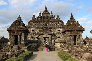
Klaten Regency is a regency in Central Java province in Indonesia. It covers an area of 701.52 km2 and had a population of 1,130,047 at the 2010 Census and 1,260,506 at the 2020 Census; the official estimate as at mid 2023 was 1,284,386. Its administrative centre is in the town of the same name; the town extends over 35.85 km2 to encompass three of the regency's districts, with a combined total of 135,681 inhabitants in mid 2023; a fourth district (Kalikotes) is part of its urban area.

Jember Regency is a regency of East Java province, in Indonesia. The land area is 3,314.13 km2, and the population was 2,332,726 at the 2010 census and 2,536,729 at the 2020 Census; the official estimate as at mid 2023 was 2,600,663. Its administrative capital is the urban area of Jember, which with 366,932 inhabitants in mid 2023 is the third largest urban area in East Java province but does not have municipality or city status as it is split between three separate administrative districts (kecamatan). Jember is famous for its tobacco farms and traditional food called tape which is made of fermented cassava.
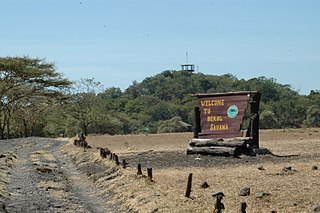
Situbondo Regency is a regency (kabupaten) in the east of East Java province, Indonesia. It covers an area of 1,658.03 km2, and had a population of 647,619 at the 2010 Census and 685,967 at the 2020 Census; the official estimate as at mid 2023 was 684,343. It is located towards the eastern end of Java, before Banyuwangi. The administrative centre is Situbondo, a small town within the regency. One of the famous tourist sites is Baluran National Park.

Sumenep, officially the Sumenep Regency, and formerly rendered Samanap or Zamanap in English, is a regency of the East Java province, Indonesia. It has an area of 2,093.47 square kilometres and the population of 1,142,210 as of 2023. The administrative capital is Kota Sumenep. Since 2014, Sumenep Regency has been recognized by UNESCO as the area that has the most Mpu in the world and most of them are in Aeng Tong-Tong Village.

Trenggalek Regency is a regency (kabupaten) in East Java, Indonesia.

Indramayu Regency is a regency (kabupaten) of the West Java province of Indonesia. It covers an area of 2,099.42 km2 and had a population of 1,663,737 at the 2010 census and 1,834,434 at the 2020 census; the official estimate as of mid 2023 was 1,894,325. The town of Indramayu is its capital.

Purwakarta Regency is a landlocked regency (kabupaten) of West Java, Indonesia. The town of Purwakarta is its regency seat.

Ngawi Regency is an inland regency (kabupaten) of Indonesia, on the island of Java. Ngawi is well known around the world for its Pithecanthropus erectus which was found by Eugene Dubois, a Dutchman. Ngawi is located in East Java Province but adjoins Central Java province. Its capital is Ngawi. Ngawi is also the main gate to enter East Java province since there are intersections that connect Surabaya–Bojonegoro–Ngawi–Solo–Jogja–Bandung–Jakarta. The Regency covers an area of 1,394.74 km2 (538.51 sq mi), and had a population of 817,765 at the 2010 census and 870,057 at the 2020 census; the official estimate as of mid-2023 was 904,094.
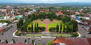
Purbalingga Regency is an inland regency in the southwestern part of Central Java province in Indonesia. Purbalingga Regency has an area of 805.76 km2 and a population of 848,952 at the 2010 census and 998,561 at the 2020 census, comprising 505,281 male and 493,280 female inhabitants; the official estimate as at mid-2023 was 1,027,333. The administrative capital is the town of Purbalingga.
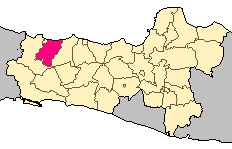
Tegal Regency is one of the regencies in the northwest part of Central Java province of Indonesia, with an area of 983.9 km2 (379.9 sq mi). The administrative center used to be in Tegal City, in the northwest corner of the regency, but then Tegal City was administratively separated from the regency and formed into its own territory. The city was later replaced as the administrative center of Tegal Regency by Slawi Town, which is a suburb about 20 km (12 mi) to the south of the city and within the district boundary. The regency had a population of 1,394,839 at the 2010 Census and 1,596,996 at the 2020 Census; the official estimate as at mid 2023 was 1,654,836.

Brebes is a regency in the northwestern part of Central Java province in Indonesia. It covers an area of 1,769.62km2, and it had a population of 1,733,869 at the 2010 Census and 1,978,759 at the 2020 Census; the official estimate as at mid 2023 was 2,043,077. Its capital is the large town of Brebes in the northeast corner of the regency, immediately adjacent to the neighbouring city of Tegal.

Brebes District is a district and the capital of Brebes Regency, Central Java, Indonesia. It is bordered by the Java Sea to the north, Tegal City and Tegal Regency to the east, Jatibarang District to the south and Wanasari District to the west. It covers 92.23 km2 and had a population of 157,149 at the 2010 Census and 182,421 at the 2020 Census.
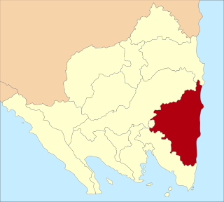
East Lampung Regency is a regency (kabupaten) of Lampung Province, Sumatra, Indonesia. It has an area of 5,325.03 km2 and a population of 951,639 people at the 2010 census and 1,110,340 at the 2020 census. The official estimate as at mid 2023 was 1,114,016 - comprising 566,648 males and 547,368 females. The regency seat is at the town of Sukadana.
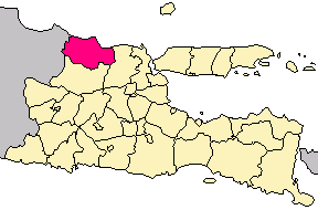
Tuban Regency is a regency in the East Java province of Indonesia. The Dutch name of the regency is 'Toeban'. It covers a land area of 1,839.94 sq. km, and had a population of 1,118,464 at the 2010 Census and 1,198,012 at the 2020 Census; the official estimate as of mid-2023 was 1,258,368. The administrative centre is the coastal town of Tuban.
Wadaslintang District is a District in Wonosobo Regency, Central Java Province Indonesia. Wadaslintang District has a postal code of 56365.


