Related Research Articles

Sir Douglas Mawson OBE FRS FAA was an Australian geologist, Antarctic explorer, and academic. Along with Roald Amundsen, Robert Falcon Scott, and Sir Ernest Shackleton, he was a key expedition leader during the Heroic Age of Antarctic Exploration.

The Scullin Monolith is a crescent-shaped rock fronting the sea 6 km (3.7 mi) west of the similar Murray Monolith, and 8 km (5.0 mi) from Torlyn Mountain, in Mac. Robertson Land, Antarctica. It is a steep massif of metasedimentary gneiss and granitic origin, with the adjacent coastline consisting of 40 m high ice cliffs. The monolith rises steeply to extend from 435 m high Mikkelsen Peak westward in a crescent that forms Douglas Bay.
The Prince Charles Mountains are a major group of mountains in Mac. Robertson Land in Antarctica, including the Athos Range, the Porthos Range, and the Aramis Range. The highest peak is Mount Menzies. Other prominent peaks are Mount Izabelle and Mount Stinear. These mountains together with other scattered peaks form an arc about 260 miles long, extending from the vicinity of Mount Starlight in the north to Goodspeed Nunataks in the south.
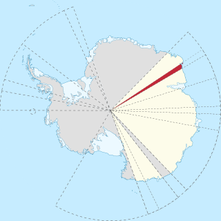
The Mawson Coast is that portion of the coast of Mac. Robertson Land, Antarctica, lying between William Scoresby Bay, at 59°34′E, and Murray Monolith, at 66°54′E. The coast was sighted during the British Australian New Zealand Antarctic Research Expedition (BANZARE), 1929–30, under Sir Douglas Mawson. Further exploration and landings at Cape Bruce and Scullin Monolith were made during BANZARE, 1930–31. Mawson Coast was named by the Antarctic Names Committee of Australia after Mawson in recognition of his great contribution to Antarctic exploration.

The Framnes Mountains are an Antarctic mountain range consisting of Casey Range, Masson Range, David Range, and Brown Range, and adjacent peaks and mountains. The three major ranges and other lesser features were sighted and named in February 1931 by the British Australian New Zealand Antarctic Research Expedition under Douglas Mawson. This coast was also sighted by Norwegian whalers in the same season. The whole area was mapped in detail by Norwegian cartographers from aerial photographs taken by the Lars Christensen Expedition in January 1937. This overall name for the several ranges was given by Lars Christensen after Framnesfjellet, a hill near Sandefjord, Norway.
The Scott Mountains are a large number of isolated peaks lying south of Amundsen Bay in Enderby Land of East Antarctica, Antarctica. Discovered on 13 January 1930 by the British Australian New Zealand Antarctic Research Expedition (BANZARE) under Sir Douglas Mawson. He named the feature Scott Range after Captain Robert Falcon Scott, Royal Navy. The term mountains is considered more appropriate because of the isolation of its individual features.

Enderby Land is a projecting landmass of Antarctica. Its shore extends from Shinnan Glacier at about 67°55′S44°38′E to William Scoresby Bay at 67°24′S59°34′E, approximately 1⁄24 of the earth's longitude. It was first documented in western and eastern literature in February 1831 by John Biscoe aboard the whaling brig Tula, and named after the Enderby Brothers of London, the ship's owners who encouraged their captains to combine exploration with sealing.
Kemp Land is a thin sliver of Antarctica including, and lying inland from, the Kemp Coast. Part of the Australian Antarctic claim it is defined as lying between 56° 25' E and 59° 34' E, and, as with other sectors of the Antarctic, is deemed being limited by the 60° S parallel. It is bounded in the east by Mac. Robertson Land and in the west by Enderby Land. Kemp Land includes one major group of islands, the Øygarden Group.
Rippon Glacier is a small glacier located in Kemp Land, East Antarctica. It is close east of Seaton Glacier, flowing southward into Edward VIII Ice Shelf.
Wilma Glacier is the western of two glaciers entering the southern part of Edward VIII Ice Shelf in Kemp Land, East Antarctica. The second, eastern glacier is Robert Glacier.
The Masson Range is a high broken chain of mountains, consisting primarily of the North Masson, Central Masson and South Masson Ranges and the Trilling Peaks, forming a part of the Framnes Mountains. Having several peaks over 1,000 metres (3,300 ft), the range extends in a north–south direction for 15 nautical miles (28 km). It was discovered and charted by the British Australian and New Zealand Antarctic Research Expedition, 1929–31, under Douglas Mawson, and named for Professor Sir David Orme Masson, a member of the Advisory Committee for this expedition as well as the Australasian Antarctic Expedition, 1911–14, also under Mawson. The mountains were first visited by an Australian National Antarctic Research Expeditions party led by John Béchervaise in 1956.
Stillwell Hills is a group of largely snow-free rocky hills composed of banded gneisses and including Kemp Peak and Lealand Bluff, extending along the southwest side of William Scoresby Bay. This area was explored by Discovery Investigations personnel on the RSS William Scoresby in February 1936, and by the Lars Christensen Expedition, 1936–37, the latter group taking air photos used to map these hills for the first time. Geologic investigation of the area was made by Australian National Antarctic Research Expeditions (ANARE) in 1961. Named by ANCA for Dr. Frank Leslie Stillwell, geologist with Australasian Antarctic Expedition (AAE), 1911–14, who derived a theory of metamorphic differentiation from banded gneisses of the same type on George V Coast.
Colbeck Archipelago is an archipelago of numerous small rocky islands centered 1 mi northwest of Byrd Head, just east of Taylor Glacier, off Mawson Coast. Discovered in January 1930 and charted in February 1931 by the British Australian and New Zealand Antarctic Research Expedition (BANZARE) under Douglas Mawson. Named by Mawson for W.R. Colbeck, second officer of the expedition ship, Discovery. Norwegian whalers who explored this same area in January 1931 named the group 4 mi to the north the Thorfinn Islands. The name Colbeck has sometimes appeared on charts for this latter group.
Oom Bay is a well-defined bay, 2 mi wide, indenting the Mawson coast between Cape Bruce and Campbell Head. Discovered in February 1931 by the British Australian and New Zealand Antarctic Research Expedition (BANZARE) under Douglas Mawson, who named it for Lieutenant K.E. Oom, RAN, cartographer with the expedition.
Cape Wilkins is a rocky cape at the north tip of Fold Island, forming the east side of the entrance to Stefansson Bay. Discovered on February 18, 1931, by the British Australian New Zealand Antarctic Research Expedition (BANZARE) under Mawson. Mapped in February 1936 by DI personnel on the William Scoresby. It was remapped in greater detail from air photos taken by the Lars Christensen Expedition, 1936–37. Mawson named this feature Cape Hearst in gratitude for the purchase of the news rights of BANZARE by the Hearst Press. Later he agreed to change the name to Cape Wilkins, the name used by subsequent expeditions.
Chapman Ridge is a ridge rising to 300 metres (1,000 ft) and extending southwest for 3 nautical miles (6 km) from Byrd Head. It was discovered by the British Australian New Zealand Antarctic Research Expedition, 1929–31, under Douglas Mawson, and mapped by Norwegian cartographers from aerial photographs taken by the Lars Christensen Expedition, 1936–37. It was named by the Antarctic Names Committee of Australia for the then-Australian scientist, Philip K. Chapman, auroral physicist at Mawson Station, during the International Geophysical Year, 1958. Chapman and Henry Fischer, a Swiss national, were members of the Australian National Antarctic Research Expedition (ANARE). They were the first humans to climb the ridge which they did several times. They did not take geological samples, make claims nor leave any marker.
Cosgrove Glacier is a small glacier entering the south part of Stefansson Bay just west of Mulebreen Glacier, Kemp Land, Antarctica. Seen from an Australian National Antarctic Research Expeditions aircraft in 1956 and later mapped, it was named by the Antarctic Names Committee of Australia for M. Cosgrove, radio supervisor at Mawson Station, 1959.
Stevenson Island is a small island 120 m high, lying at the east side of Colbeck Archipelago, 2 nautical miles (3.7 km) northeast of Cape Simpson. Discovered in February 1931 by the British Australian New Zealand Antarctic Research Expedition (BANZARE) under Mawson. He named it for Captain J.B. Stevenson, Royal Navy, a member of the Australian Aurora Committee, 1916–17.
Mount Johnston is the southernmost peak of the Fisher Massif, and at 1,770 metres (5,800 ft) the highest. It stands just west of Lambert Glacier in the Prince Charles Mountains of Antarctica. The mountain was first visited by an Australian National Antarctic Research Expeditions party led by B.H. Stinear in October 1957, and was named by the Antarctic Names Committee of Australia for Flying Officer D.M. Johnston, a pilot with the Royal Australian Air Force Flight at Mawson Station in 1957.
Mount Hordern is a peak, 1,510 metres (4,950 ft) high, standing 4 nautical miles (7 km) south of Mount Coates in the David Range of Antarctica. It was discovered in February 1931 by the British Australian New Zealand Antarctic Research Expedition under Mawson, and named for Sir Samuel Hordern, a patron of this expedition and of the Australasian Antarctic Expedition under Mawson, 1911–14.
References
- ↑ "Kemp Peak". Geographic Names Information System . United States Geological Survey . Retrieved 2010-08-04.