Kenghkam

Last updated
Kenghkam State
State of the Shan States
1811–1882
Shan-S-IGI.jpg
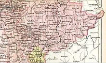
Keng Hkam State in an Imperial Gazetteer of India map
Capital Keng Hkam
Area 
 1901
432.5 km2 (167.0 sq mi)
Population 
 1901
5,458
History 
 State founded
1811
 Annexed by Mongnai State
1882
Preceded by
Succeeded by
Blank.png Konbaung dynasty
Mongnai State Blank.png

Kenghkam or Keng Hkam (also known as Kyaingkan) was a Shan state in what is today Burma. The capital was the town of Keng Hkam, located by the Nam Pang River. [1]

Contents

History

Kenghkam was initially a tributary of the Konbaung dynasty. It was founded in 1811 and was located north of the sub-state of Kengtawng. The state was occupied by Mongnai State from 1870 to 1874 and again from 1878 to 1882, when it was annexed directly. [2]

Rulers

The rulers of the state bore the title Myoza. [3]

See also

Related Research Articles

<span class="mw-page-title-main">Mang Lon</span>

Mang Lon, Manglon, Manglun, Manglön, or Mang Lön a state in the northern Shan states of Myanmar, was formerly the chief state of the Wa people. It is a mountainous territory, including the valleys of the Salween and its tributary the Nam Hka. It had an approximate area of 7770 km2 and its estimated population in 1911 was 40,000.

<span class="mw-page-title-main">Laihka State</span>

Laihka State, also spelt Legya or Lecha, was a state in the central division of the Southern Shan States of Burma, with an area of 3,711 square kilometres (1,433 sq mi).

<span class="mw-page-title-main">Yawnghwe</span> Shan state in Burma (1359–1959)

Yawnghwe, known as Nyaungshwe in Burmese, was a Shan state in what is today Myanmar. It was one of the most important of the Southern Shan States. Yawnghwe state included the Inle Lake. The administrative capital was Taunggyi, located in the northern part of the state. The Agent of the British government, the Superintendent of the Southern Shan States, resided at Taunggyi and the king's palace was at Yawnghwe.

<span class="mw-page-title-main">Tip Htila</span> Saopha of Kenghkam

Sao Nang Tip Htila was a Saopha of Kenghkam State. She was the only female Saopha in Burma and Shan History. She married Hkun Un, Saopha of Kenghkam and became the Mahadevi of Kenghkam. After her husband's death, she became the Saopha in lieu of her adolescent son and became one of the most powerful women in Kenghkam, controlling the state economically and politically. A powerful figure in her own right, she was renowned for her cunning and charisma and was admired by her countrymen and the British.

<span class="mw-page-title-main">Mong Kung Township</span> Township in Shan State, Burma

Mong Kung Township or Mongkaung Township is a township of Loilen District in the Shan State of Burma. The principal town is Mong Kung.

<span class="mw-page-title-main">Longchuan County, Yunnan</span> County in Yunnan, China

Longchuan County is a county located in Dehong Prefecture, Yunnan province, southwestern China.

<span class="mw-page-title-main">Chiang Hung</span> Shan state under Burma and China (1180–1950)

Chiang Hung, Sipsongpanna or Keng Hung was one of the states of Shans under the suzerainty of Burma and China.

<span class="mw-page-title-main">Kengcheng</span> Former Shan state in Burma

Kengcheng or Keng Cheng was one of the Shan states. In 1896, part of Keng Cheng was incorporated into the neighbouring state of Kengtung in what is today Burma, and the other part, which is now in Laos, went to French Indochina.

<span class="mw-page-title-main">Kenglon</span>

Kenglon, also known as Kyainglun was a small Shan state in what is today Burma.

Mawnang was a small Shan state in the Myelat region of what is today Burma. Its population was mostly Taungyo.

<span class="mw-page-title-main">Mongpawn</span> Former Shan state in Burma

Mongpawn, also known as Maingpun, was a Shan state in what is today Burma. The state was part of the Eastern Division of the Southern Shan States and was located south of Laihka State in the valley of the Nam Pawn river.

<span class="mw-page-title-main">Mongsit</span>

Mongsit or Möngsit, also known as Maingseik was small state of the Shan States in what is today Burma.

<span class="mw-page-title-main">Hsipaw</span> Town in Shan State, Myanmar

Hsipaw, also known as Thibaw, is the principal town of Hsipaw Township in Shan State, Myanmar on the banks of the Duthawadi River. It is 200 kilometres (120 mi) north-east of Mandalay.

<span class="mw-page-title-main">Hsipaw State</span> Former Shan state in Burma

Hsipaw, also known as Thibaw, was a Shan state in what is today Myanmar. Its capital was Hsipaw town. Hsipaw State was perhaps one of the most well known and powerful Shan States.

<span class="mw-page-title-main">Mongmit State</span> Former Shan state in Burma

Mongmit or Möngmit, also known as Momeik, was a Shan state in the Northern Shan States in what is today Burma. The capital was Mongmit town. The state included the townships of Mongmit and Kodaung.

<span class="mw-page-title-main">Mongnai State</span> Former Shan state in Burma

Mongnai, also known as Möngnai, Mone, Mōng Nai or Monē, was a Shan state in what is today Burma. It belonged to the Eastern Division of the Southern Shan States. Its capital was Mongnai town.

<span class="mw-page-title-main">Mongpan State</span>

Mongpan, also known as Maingpan was a Shan state in what is today Burma. It belonged to the Eastern Division of the Southern Shan States.

<span class="mw-page-title-main">Lawksawk State</span>

Lawksawk, also known as Yatsawk was a Shan state in what is today Burma. It was located north of Myelat and belonged to the Central Division of the Southern Shan States. Its capital was Lawksawk town. The state included 397 villages and the population was mostly Shan, but there were also Danu, Pa-O and Palaung people in the area.

<span class="mw-page-title-main">Mongpai</span> Former Shan state in Burma

Mongpai, also known as Mobye, was a Shan state in what is today Burma. It belonged to the Central Division of the Southern Shan States. Mongpai was based in the modern town of Mobye.

<span class="mw-page-title-main">Tawngpeng State</span>

Tawngpeng was a Shan state in what is today Myanmar. It belonged to the Northern Shan States. The capital was Namhsan (Om-yar).

References

  1. Imperial Gazetteer of India, v. 15, p. 200.
  2. "WHKMLA : History of the Shan States". 18 May 2010. Retrieved 21 December 2010.
  3. Ben Cahoon (2000). "World Statesmen.org: Shan and Karenni States of Burma" . Retrieved 21 December 2010.

21°52′0″N97°22′0″E / 21.86667°N 97.36667°E / 21.86667; 97.36667