Wuntho or Waing Hso was a native state of Upper Burma when Burma (Myanmar), was under British control. It had an area of around 6,200 square kilometres (2,400 sq mi) with 150,000 inhabitants and lay midway between the Ayeyarwady River and Chindwin Rivers.

Mang Lon, Manglon, Manglun, Manglön, or Mang Lön a state in the northern Shan states of Myanmar, was formerly the chief state of the Wa people. It is a mountainous territory, including the valleys of the Salween and its tributary the Nam Hka. It had an approximate area of 7770 km2 and its estimated population in 1911 was 40,000.
Laihka State, also spelt Legya or Lecha, was a state in the central division of the Southern Shan States of Burma, with an area of 3,711 square kilometres (1,433 sq mi).
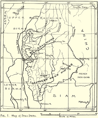
Yawnghwe, known as Nyaungshwe in Burmese, was a Shan state in what is today Myanmar. It was one of the most important of the Southern Shan States. Yawnghwe state included the Inle Lake. The administrative capital was Taunggyi, located in the northern part of the state. The Agent of the British government, the Superintendent of the Southern Shan States, resided at Taunggyi and the king's palace was at Yawnghwe.
Muang Mao, also spelled MöngMao or the Mao Kingdom, was an ethnic Dai state that controlled several smaller Tai states or chieftainships along the frontier of what is now Myanmar, China, the states of Northeast India of Assam, Nagaland, Manipur and Arunachal Pradesh principally set in the Dehong region of Yunnan with a capital near the modern-day border town of Ruili/Meng Mao. The name of the main river in this region is the Nam Mao, also known as the Shweli River.
Momeik, also known as Mong Mit in Shan, is a town situated on the Shweli River in northern Shan State. It is the principal town of Mongmit Township, Myanmar.
Kengcheng or Keng Cheng was one of the Shan states. In 1896, part of Keng Cheng was incorporated into the neighbouring state of Kengtung in what is today Burma, and the other part, which is now in Laos, went to French Indochina.
Mawnang was a small Shan state in the Myelat region of what is today Burma. Its population was mostly Taungyo.

Hsipaw, also known as Thibaw, is the principal town of Hsipaw Township in Shan State, Myanmar on the banks of the Duthawadi River. It is 200 kilometres (120 mi) north-east of Mandalay.

Kantarawadi, also known as Gantarawadi, was one of the Karenni States in what is today Kayah State in Burma. It was also known as "Eastern Karenni" owing to the location of part of its territory east of the Salween River.
Mongmit or Möngmit, also known as Momeik, was a Shan state in the Northern Shan States in what is today Burma. The capital was Mongmit town. The state included the townships of Mongmit and Kodaung.
North Hsenwi was a Shan state in the Northern Shan States in what is today Burma. The capital was Lashio town which was also the headquarters of the superintendent of the Northern Shan State. North Hsenwi, with an area of 6330 m², had a population in 1901 of 118,325 persons and an estimated revenue of £6000.

Mawkmai, also known as Maukme, was a Shan State in what is today Burma. It belonged to the Eastern Division of the Southern Shan States.

Mongkung, also known as Maingkaing, was a Shan state in what is today Burma. It belonged to the Eastern Division of the Southern Shan States. Its capital was Mong Kung, in the valley of the Nam Teng. The largest minority were Palaung people.
Mongpan, also known as Maingpan was a Shan state in what is today Burma. It belonged to the Eastern Division of the Southern Shan States.
Lawksawk, also known as Yatsawk was a Shan state in what is today Burma. It was located north of Myelat and belonged to the Central Division of the Southern Shan States. Its capital was Lawksawk town. The state included 397 villages and the population was mostly Shan, but there were also Danu, Pa-O and Palaung people in the area.

Mongpai, also known as Mobye, was a Shan state in what is today Burma. It belonged to the Central Division of the Southern Shan States. Mongpai was based in the modern town of Mobye.
The Kingdom of Pong or Pong Kingdom was an ethnically Tai state that controlled several smaller states along the frontier of what is now Myanmar, China and Northeast Indian states of Assam, Manipur, Nagaland and Arunachal Pradesh.
Hsawnghsup was one of the outlying Shan princely states in what is today Burma.
Mogaung or Möngkawng was a Shan state in what is present-day Myanmar. It was an outlying territory, located away from the main Shan State area in present-day Kachin State. The state existed until 1796. The main town was Mogaung.
