Wanmaw State

Last updated
Wanmaw State (Bhamo)
State of the Shan States
1470–1772
Map of Toungoo Kingdom 1572.jpg
Wanmaw (Bhamo) in a map of the Toungoo Kingdom
History 
 Wanmaw state established
1470
 Annexed by the Kingdom of Burma
1772
Succeeded by
Taungoo Dynasty Blank.png
Today part of Bhamo District, Myanmar

Wanmaw, Manmaw or Banmaw (Bhamo) was a Shan state in what is today Burma. It was an outlying territory, located away from the main Shan State area in present-day Kachin State close to the border with China.

Contents

The state existed until 1772. The main town was Man Maw (Bhamo). The name of the state means 'the village of pots (or potters)' in the Shan language. [1]

History

The early history of the state is obscure. But legends tell of a powerful predecessor Tai state having been established in the area previously which had its capital at the now ruined place of Sampenago. The ruins of the old city walls, dating from the fifth Century, are found some 5 km from the modern town of Bhamo. The ancient capital of Sampenago was renowned for its stupas housing relics of the Buddha.

...  The Burmese Buddhists know little of Kanishka, but the name of Dhammathawka is well known, and tradition credits him with the foundation of many pagodas with the bones and relics of the Buddha. ... There are many of these shwemōkthos and shwemōkdaws in the Upper Province, and even farther off still, in the tributary Shan States : at Kyaukse, Sampenago, in the Bhamo District  ; at Pwela in the Myelat, round the Inle lake, and in many parts of the hills. They are all implicitly credited to Dhammathawka... [2]

In 1668 a saopha of Wanmaw named Sao Ngawk Hpa is said to have instigated an attack by the Chinese against the Kingdom of Burma. [1] Wanmaw was subsequently occupied by Burma between 1669 and 1685 and again in mid 18th century. After regaining independence in 1742 it was again occupied by Burma from 1767 to 1770 after a Chinese invasion was repelled. Finally Wanmaw was annexed by the Burmese Ava Kingdom in 1772. [3] The control of this frontier state by the Burmese Kingdom was loose and at the time of the beginning of British rule in Burma the wun in charge of the administration of the territory was de facto quite independent. [1]

Rulers

The rulers of the state bore the title Saopha . Myowuns or wuns were the administrators of the territory of the former state after annexation by Burma. [4]

Saophas

This state existed 1470-1772, when it was incorporated into Burma.

Saophas:

  • Sao Lin Hpa 1470-1482
  • Sao Heng Hpa 1482-1485
  • Sao Hang Hpa 1485-1507
  • Sao Hsaw Hpa 1507-1518
  • Sao Tu Hpa 1518-1543
  • Sao Sawk Hpa 1543-1582
  • Sao Yung Hpa 1582-1588
  • Sao Sin Hpa 1588-1603
  • Hseng Lung Hpa 1603-1634
  • Sao San Hpa 1634-1646
  • Sao Law San 1646-1647
  • Sao Lin Hpa 1647-1653
  • Sao Hsawk Hpa 1653-1668
  • Sao Ngawk Hpa 1668-1669
  • Min Gon burmese general 1669-1674
  • Nge Myat burmese merchant 1674-1685
  • Sao Hpi Hpa 1685-1706
  • Sao Tun Hpa 1706-1719
  • Hpo U 1719-1720
  • Sao Möng Hpa 1720-1727
  • Sao Tung Ngai 1st time 1727-1735
  • Haw Kit 1735-1742
  • Sao Tung Ngai 2nd time 1742-1768
  • Vacant 1768-1770
  • Sao Myat Aung 1770-1772 (b.1690-c.1772) son of saopha of Mongmit

Myowuns:

  • 1772-17??: Mingyi Wailuthaya (U Shwe Ye)
  • 1853-18??: Mingyi Maha Minhtin Yaza
  • 1878-18??: U Pho Hla

Related Research Articles

<span class="mw-page-title-main">Wuntho</span>

Wuntho or Waing Hso was a native state of Upper Burma when Burma (Myanmar), was under British control. It had an area of around 6,200 square kilometres (2,400 sq mi) with 150,000 inhabitants and lay midway between the Ayeyarwady River and Chindwin Rivers.

<span class="mw-page-title-main">Yawnghwe</span> Shan state in Burma (1359–1959)

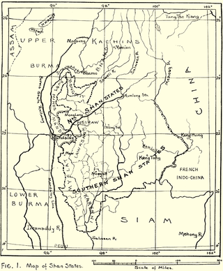
Yawnghwe, known as Nyaungshwe in Burmese, was a Shan state in what is today Myanmar. It was one of the most important of the Southern Shan States. Yawnghwe state included the Inle Lake. The administrative capital was Taunggyi, located in the northern part of the state. The Agent of the British government, the Superintendent of the Southern Shan States, resided at Taunggyi and the king's palace was at Yawnghwe.

Man Maw is a village in Bhamo Township in Bhamo District in the Kachin State of north-eastern Burma.

Momeik, also known as Mong Mit in Shan, is a town situated on the Shweli River in northern Shan State. It is the principal town of Mongmit Township, Myanmar.

Narapati I of Ava was king of Ava from 1442 to 1468. In the early years of his reign, this former viceroy of Prome (Pyay) was forced to deal with raids from the Shan State of Mogaung as well as the Ming Chinese intrusions into Avan territory (1444–1446). In the wake of renewed Chinese determination to pacify the Yunnan frontier region, Narapati was able to maintain Ava's control of northern Shan States of Kale and Mohnyin, and gained allegiance of Thibaw. However, he continued to have trouble with Toungoo which was in revolt between 1451 and 1459. One of his grandsons attempted on his life in June 1467. The king fled Ava for Prome and died there in July 1468.

Shwenankyawshin Narapati was king of Ava from 1501 to 1527. His reign saw the disintegration of the Ava Kingdom. He spent much of his reign fighting back the attacks from the Confederation of Shan States. But his efforts ultimately proved unsuccessful. The king died fighting while defending his capital from Confederation attacks, after which Ava Kingdom was taken over by the Confederation.

Sawlon of Mohnyin Tai name's Hso Lung Hpa was saopha of the Shan state of Mohnyin in the early the 16th century. He is best remembered in Burmese history as the conqueror of Ava Kingdom.

<span class="mw-page-title-main">Hsipaw</span> Town in Shan State, Myanmar

Hsipaw, also known as Thibaw, is the principal town of Hsipaw Township in Shan State, Myanmar on the banks of the Duthawadi River. It is 200 kilometres (120 mi) north-east of Mandalay.

<span class="mw-page-title-main">Hsipaw State</span> Former Shan state in Burma

Hsipaw, also known as Thibaw, was a Shan state in what is today Myanmar. Its capital was Hsipaw town. Hsipaw State was perhaps one of the most well known and powerful Shan States.

<span class="mw-page-title-main">Mongmit State</span> Former Shan state in Burma

Mongmit or Möngmit, also known as Momeik, was a Shan state in the Northern Shan States in what is today Burma. The capital was Mongmit town. The state included the townships of Mongmit and Kodaung.

<span class="mw-page-title-main">Mongnai State</span> Former Shan state in Burma

Mongnai, also known as Möngnai, Mone, Mōng Nai or Monē, was a Shan state in what is today Burma. It belonged to the Eastern Division of the Southern Shan States. Its capital was Mongnai town.

<span class="mw-page-title-main">Lawksawk State</span>

Lawksawk, also known as Yatsawk was a Shan state in what is today Burma. It was located north of Myelat and belonged to the Central Division of the Southern Shan States. Its capital was Lawksawk town. The state included 397 villages and the population was mostly Shan, but there were also Danu, Pa-O and Palaung people in the area.

<span class="mw-page-title-main">Mongyang State</span>

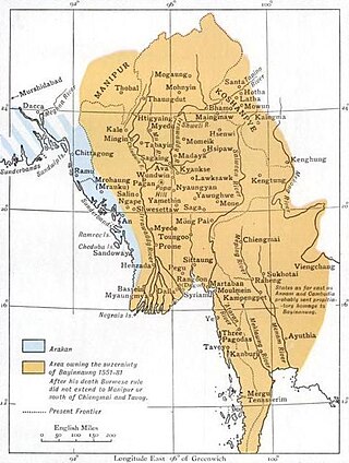
Mongyang or Möngyang was a Shan state in what is today Burma. It was an outlying territory, located away from the main Shan State area in present-day Kachin State. The state existed before 1400 and after 1604. The main town was Mohnyin.

<span class="mw-page-title-main">Mongkawng</span> Former Shan state in Burma

Mogaung or Möngkawng was a Shan state in what is present-day Myanmar. It was an outlying territory, located away from the main Shan State area in present-day Kachin State. The state existed until 1796. The main town was Mogaung.

<span class="mw-page-title-main">Chiefdom of Mangshi</span>

The Chiefdom of Mangshi, officially Mangshi Yuyi Zhangguansi and Mangshi Anfusi was a Dai autonomous Tusi chiefdom in the west of Yunnan, China from 1443 to 1955. In 1443, the Ming dynasty established Mangshi Yuyi Zhangguansi (芒市御夷长官司) because a Mangshi chief made a contribution in Luchuan–Pingmian campaigns, and then upgraded to Mangshi Anfusi (芒市安抚司) in 1640. Chiefdom of Mangshi has an absolute dictatorship in politics, military, economy at the territory, and use the rule of primogeniture.

References

  1. 1 2 3 Imperial Gazetteer of India, v. 8, p. 47. - Bhamo District, History
  2. Buddhism in Burma and Assam by D. J. Gogerly, Colombo, Ceylon 1870
  3. Shan (Tai) States
  4. Nisbet, John (1901). Burma Under British Rule—and Before. Vol. 1. Archbald Constable & Company.

24°33′N97°7′E / 24.550°N 97.117°E / 24.550; 97.117