Maw (state)

Last updated
Maw
State of the Shan States
1934 Flag of the United Kingdom.svg
Location of Maw Shan States-Map.png
Location of Maw
Maw State (in violet) in a map of the Shan States
History
  State foundedEnter start date
  Merged with Hsamönghkam 1934
Area
  1901885 km2(342 sq mi)
Population
  19017,743 
Density 8.7 /km2  (22.7 /sq mi)

Maw (Burmese : Baw), was a Shan state in what is today Burma. It was the northernmost and the second largest of the states of the Myelat region at the western end of the Shan States. [1]

Burmese language language spoken in Myanmar

The Burmese language is a Sino-Tibetan language spoken in Myanmar where it is an official language and the language of the Bamar people, the country's principal ethnic group. Although the Constitution of Myanmar officially recognizes the English name of the language as the Myanmar language, most English speakers continue to refer to the language as Burmese, after Burma, the older name for Myanmar. In 2007, it was spoken as a first language by 33 million, primarily the Bamar (Burman) people and related ethnic groups, and as a second language by 10 million, particularly ethnic minorities in Myanmar and neighboring countries.

Shan States historic (1885-1948) name for Minor Kingdoms (analogous to Princely state of British India) ruled by Saopha (similar to Thai royal title Chao Fa Prince/Princess) in areas of todays Burma, China, Laos and Northern Thailand from c.1215 to c.1959

The Shan States (1885–1948) were a collection of minor Shan kingdoms called mueang whose rulers bore the title saopha in British Burma. They were analogous to the princely states of British India.

Myelat Historical region in Myanmar

Myelat is a historical region of the southwestern Shan State of Myanmar. Originally this region included some of the smaller states typically ruled by "Myosas" or "Ngwegunhmus", buffering the plains of Burma and the ethnic Shan states further east.

Contents

The capital of the state and residence of the Ngwegunhmu was Myogyi, located on the western slopes of the westernmost range of the Shan Hills. Maw included the valley of the Zawgyi River and the Myelat plateau to the south. Its population was mostly Danu, but there were also Pa-O, Shan and Palaung people in the area. [2]

Shan Hills Mountainous zone in Yunnan, Myanmar and Thailand

The Shan Hills, also known as Shan Highland, is a vast mountainous zone that extends through Yunnan to Myanmar and Thailand. The whole region is made up of numerous mountain ranges separated mostly by narrow valleys as well as a few broader intermontane basins. The ranges in the area are aligned in such a way that they link to the foothills of the Himalayas further to the northwest.

Zawgyi River is a river of eastern Burma (Myanmar). It flows through the foothills of the Shan Mountain range in Shan State. It is a tributary of the Myitnge River (Doktawaddy) entering it about 20 km north of Kyaukse at Nyaungbintha.

Danu people ethnic group in Myanmar

The Danu people are a government-recognized ethnic group in Myanmar, predominantly populating the areas near the Pindaya Caves in Shan State. They speak the Danu language.

History

Maw was a tributary state to the King of Burma. In 1886 the ruler of Maw took part in the confederation against British rule in Burma, but he submitted quickly after British victory. Thus his possession of the territory was acknowledged by the colonial authorities in 1887. Maw State merged with Hsamönghkam State in 1934. [3]

British rule in Burma Historical time period

British rule in Burma lasted from 1824 to 1948, from the Anglo-Burmese wars through the creation of Burma as a Province of British India to the establishment of an independently administered colony, and finally independence. The region under British control was known as British Burma. Various portions of Burmese territories, including Arakan, Tenasserim were annexed by the British after their victory in the First Anglo-Burmese War; Lower Burma was annexed in 1852 after the Second Anglo-Burmese War. The annexed territories were designated the minor province, British Burma, of British India in 1862.

Hsamonghkam or Hsamönghkam was a Shan state in the Myelat region of Burma. Its capital was Aungban.

Rulers

The rulers bore the title Ngwegunhmu (silver revenue chief) until 1907. [4]

Ngwegunhmus

  • .... - .... Ko Thien Shin [1st ruler]
  • .... - .... Thudewa
  • .... - .... .... [12 rulers]
  • .... - .... Maung Chwin
  • 17.. - 1873 Maung Kya O
  • 1873 - .... Maung Yit -Regent
  • 1873 - 1907 Maung Nyo Hlaing (b. 1860 - d. 1921)
  • .... - 1882 Maung On Gaing -Regent

Myosas

  • 1907 - 1921 Maung Nyo Hlaing (s.a.)
  • 1921 - 19.. Maung Thu Daw

Related Research Articles

Wuntho

Wuntho or Waing Hso was a native state of Upper Burma when Burma (Myanmar), was under British control. It had an area of around 6,200 square kilometres (2,400 sq mi) with 150,000 inhabitants and lay midway between the Ayeyarwady River and Chindwin River.

Mang Lon

Mang Lon, Manglon, Manglun or Manglön, a state in the northern Shan states of Myanmar, was formerly the chief state of the Wa people. It is a mountainous territory, including the valleys of the Salween and its tributary the Nam Hka. It had an approximate area of 7770 km² and its estimated population in 1911 was 40,000.

Yawnghwe former Shan state in what is today Burma

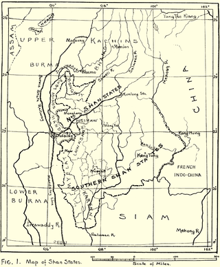
Yawnghwe, known as Nyaungshwe in Burmese, was a Shan state in what is today Myanmar. It was one of the most important of the Southern Shan States. Yawnghwe state included the Inle Lake. The administrative capital was Taunggyi, located in the northern part of the state. The Agent of the British government, the Superintendent of the Southern Shan States, resided at Taunggyi and the king's palace was at Yawnghwe.

Kengcheng

Kengcheng or Keng Cheng was one of the Shan states. In 1896, part of Keng Cheng was incorporated into the neighbouring state of Kengtung in what is today Burma, and the other part, which is now in Laos, went to French Indochina.

Kenglon

Kenglon was a small Shan state in what is today Burma.

Kyawkku State

Kyawkku was a Shan state in the Myelat region of what is today Burma. Its capital was the village of Kyawkku (Myinkyado) which had 344 inhabitants in 1901.

Kyong

Kyong was a Shan state in the Myelat region of what is today Burma.

Loi-ai

Loi-ai was a Shan state in the Myelat region of what is today Burma. It was one of the westernmost Shan states, bordering with Yamethin district of Upper Burma. The capital was Lonpo (Aungpan) and the population was mostly Pa-O, but there were also Danu, Shan and Karen people in the area.

Mawnang was a small Shan state in the Myelat region of what is today Burma. Its population was mostly Taungyo.

Namhkai was a Shan state in the Myelat region of what is today Burma. Its capital was Paw-in. Its population was almost entirely Pa-O.

Singaling Hkamti one of the outlying Shan states

Singaling Hkamti was a Shan state in what is today Burma. It was an outlying territory, away from the main Shan State area. The state was located on both sides of the Chindwin River, in what is present-day Homalin Township, Sagaing Region. Its capital was Singaling Hkamti town.

Mongkung State

Mongkung or Möngküng was a Shan state in what is today Burma. It belonged to the Eastern Division of the Southern Shan States. Its capital was Mong Kung, in the valley of the Nam Teng. The largest minority were Palaung people.

Mongpan State

Mongpan or Möngpan was a Shan state in what is today Burma. It belonged to the Eastern Division of the Southern Shan States.

Lawksawk State

Lawksawk (Yatsawk) was a Shan state in what is today Burma. It was located north of Myelat and belonged to the Central Division of the Southern Shan States. Its capital was Lawksawk town. The state included 397 villages and the population was mostly Shan, but there were also Danu, Pa-O and Palaung people in the area.

Pangtara was a Shan state in what is today the Pindaya Township of Burma. It belonged to the Myelat Division of the Southern Shan States.

Yengan was a Shan state in what is today Burma. It belonged to the Myelat Division of the Southern Shan States.

Hsawnghsup

Hsawnghsup was one of the outlying Shan princely states in what is today Burma.

Mongkawng

Mogaung or Möngkawng was a Shan state in what is today Burma. It was an outlying territory, located away from the main Shan State area in present-day Kachin State. The state existed until 1796. The main town was Mogaung.

References

  1. "WHKMLA : History of the Shan States". 18 May 2010. Retrieved 21 December 2010.
  2. Imperial Gazetteer of India, v. 17, p. 234.
  3. Burmese Princely States
  4. Shan and Karenni States of Burma

Coordinates: 21°27′N96°22′E / 21.450°N 96.367°E / 21.450; 96.367

Geographic coordinate system Coordinate system

A geographic coordinate system is a coordinate system that enables every location on Earth to be specified by a set of numbers, letters or symbols. The coordinates are often chosen such that one of the numbers represents a vertical position and two or three of the numbers represent a horizontal position; alternatively, a geographic position may be expressed in a combined three-dimensional Cartesian vector. A common choice of coordinates is latitude, longitude and elevation. To specify a location on a plane requires a map projection.