
Kensington New Town is an area of housing in Kensington, London, which was developed in the early 19th century. [2] It lies to the south of Kensington High Street and to the southwest of Kensington Gardens. [3]

Kensington New Town is an area of housing in Kensington, London, which was developed in the early 19th century. [2] It lies to the south of Kensington High Street and to the southwest of Kensington Gardens. [3]
The area first began to be built up in 1837, and the original construction continued until 1846. [4] The developers included John Inderwick, a successful pipe-maker and tobacconist; John James Vallotton, who was a successful haberdasher in Jermyn Street; and Jonathan Hamston who was a carpenter and builder. [1] The core of the district is the intersection of Launceston Place and Victoria Grove. Many of the original late Regency style buildings are still present into the 21st century. [4] Most of the buildings in the area have an off-white or cream stucco exterior coating, with a small amount of brick houses. The Gloucester Arms, a Grade II listed pub, is at the centre of the area, along with various shops. [3] [5]
The borough council recognised and protected this area as the Kensington New Town Conservation Area in 1969 and this has since been extended to become the De Vere Conservation Area. [3]

Kensington is an affluent district in the Royal Borough of Kensington and Chelsea in the West of Central London.

The Royal Borough of Kensington and Chelsea (RBKC) is an Inner London borough with royal status. It is the smallest borough in London and the second smallest district in England; it is one of the most densely populated administrative regions in the United Kingdom. It includes affluent areas such as Notting Hill, Kensington, South Kensington, Chelsea, and Knightsbridge.

The London Borough of Hammersmith and Fulham is a London borough in West London and which also forms part of Inner London. The borough was formed in 1965 from the merger of the former Metropolitan Boroughs of Hammersmith and Fulham. The borough borders Brent to the north, the Royal Borough of Kensington and Chelsea to the east, Wandsworth to the south, Richmond upon Thames to the south west, and Hounslow and Ealing to the west.
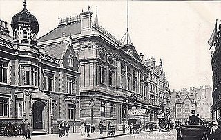
The Metropolitan Borough of Kensington was a Metropolitan borough in the County of London from 1900 to 1965, which since 1901 was known as the Royal Borough of Kensington, following the death of Queen Victoria, in accordance with her wishes.

Cromwell Road is a major London road in the Royal Borough of Kensington and Chelsea, designated as part of the A4. It was created in the 19th century and is said to be named after Richard Cromwell, son of Oliver Cromwell, who once owned a house there.

Kensington High Street is the main shopping street in Kensington, London. The area is identified in the London Plan as one of 35 major centres in Greater London.
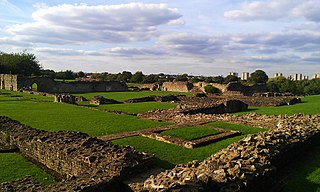
Lesnes Abbey is a former abbey, now ruined, in Abbey Wood, in the London Borough of Bexley, southeast London, England. It is a scheduled monument, and the abbey's ruins are listed at Grade II by Historic England. The adjacent Lesnes Abbey Woods are a Local Nature Reserve. Part of the wood is the Abbey Wood SSSI, a geological Site of Special Scientific Interest which is an important site for early Tertiary fossils.

Gloucester Road (B325) is a street in the Royal Borough of Kensington and Chelsea of London. It runs north–south between Kensington Gardens and the Old Brompton Road at the south end.

Brompton, sometimes called Old Brompton, survives in name as a ward in the Royal Borough of Kensington and Chelsea in London. Until the latter half of the 19th century it was a scattered village made up mostly of market gardens in the county of Middlesex. It lay south-east of the village of Kensington, abutting the parish of St Margaret's, Westminster at the hamlet of Knightsbridge to the north-east, with Little Chelsea to the south. It was bisected by the Fulham Turnpike, the main road westward out of London to the ancient parish of Fulham and on to Putney and Surrey. It saw its first parish church, Holy Trinity Brompton, only in 1829. Today the village has been comprehensively eclipsed by segmentation due principally to railway development culminating in London Underground lines, and its imposition of station names, including Knightsbridge, South Kensington and Gloucester Road as the names of stops during accelerated urbanisation, but lacking any cogent reference to local history and usage or distinctions from neighbouring settlements.

Queen's Gate is a street in South Kensington, London, England. It runs south from Kensington Gardens' Queen's Gate to Old Brompton Road, intersecting Cromwell Road.

The Boltons is a street and garden square of lens shape in the Brompton district of the Royal Borough of Kensington and Chelsea, London, England. The opposing sides of the street face the communal gardens with large expansive houses and gardens, in what is considered the third-most expensive street in the country with the average house price at 15 million pounds. The elliptical central gardens of the Boltons are Grade II listed on the Register of Historic Parks and Gardens.

Marylebone is a district in the West End of London, in the City of Westminster. Oxford Street, Europe's busiest shopping street, forms its southern boundary.

St Mary Abbots is a church located on Kensington High Street and the corner of Kensington Church Street in London W8.

Radnor Walk is a residential street in the Royal Borough of Kensington & Chelsea off the King's Road in London. The houses are mid and late Victorian and the street is part of the Royal Hospital Conservation Area. It was originally called Radnor Street, and was named after John Robartes, 1st Earl of Radnor who died in Chelsea in 1685. It was renamed Radnor Walk in 1937.

The Westgate area of Gloucester is centred on Westgate Street, one of the four main streets of Gloucester and one of the oldest parts of the city. The population of the Westgate ward in Gloucester was 6,687 at the time of the 2011 Census.
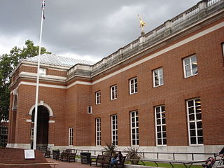
Kensington Central Library is a Grade II* listed building on Hornton Street and Phillimore Walk, Kensington, London. It was built in 1958–60 by the architect E. Vincent Harris on the site of The Abbey, a Gothic house which had been constructed for a Mr Abbot in 1880 and destroyed by bombing in 1944. It was opened by the Queen Elizabeth The Queen Mother on 13 July 1960. The building was designed in a traditional, English, renaissance-style. There were demonstrations against the project by those who advocated for the building to be in a modern style.

Victoria Grove is a street in Kensington, London W8. House building began in 1837 and was completed in 1841.
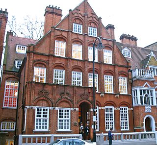
Harrington Gardens is a street which has a communal garden regionally sometimes known as a garden square in the Royal Borough of Kensington and Chelsea in London. The street runs from Collingham Gardens and Collingham Road in the east to Gloucester Road and Stanhope Gardens in the west. It is crossed by Ashburn Place and joined by Colbeck Mews on its north side. It contains several listed buildings including an important group of grade II* buildings on the south side numbered 35 to 45.

Oakley Street is in the Royal Borough of Kensington and Chelsea, London. It runs roughly north to south from King's Road to the crossroads with Cheyne Walk and the River Thames, where it continues as the Albert Bridge and Albert Bridge Road. The street was named after Baron Cadogan of Oakley.
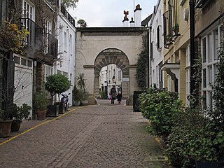
Kynance Mews is a mews street in South Kensington district of the Royal Borough of Kensington and Chelsea in London, SW7. The mews consists of 33 residential properties on a setted road that passes from Gloucester Road on the east, before being bisected by Launceston Place, with the western end of the mews ending in a cul-de-sac. The entrances to the mews pass through three arches, each listed Grade II on the National Heritage List for England. The arches were built c. 1860 to a design by Thomas Cundy III.
Coordinates: 51°29′55.61″N0°11′3.15″W / 51.4987806°N 0.1842083°W