
Bakersfield is a city in and the county seat of Kern County, California, United States. The city covers about 151 sq mi (390 km2) near the southern end of the San Joaquin Valley, which is located in the Central Valley region.

Meadows Field is a public airport in Kern County, California, United States, three miles northwest of downtown Bakersfield. It is the main airport for the Bakersfield area, and one of two international airports in the San Joaquin Valley, the other Fresno Yosemite International Airport. Also known as Kern County Airport #1, it is located in an area of unincorporated Kern County adjacent to Oildale, California.

State Route 204 is a state highway in the U.S. state of California that connects SR 58 and SR 99 in the Bakersfield area. Passing through downtown Bakersfield, SR 204 also connects Bakersfield's three major freeways together. Only the northern 1.4 miles (2.3 km) has been built to freeway standards; the rest is a six-lane arterial road.
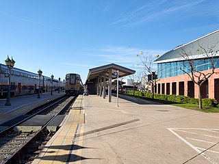
Bakersfield station is an intermodal facility in Bakersfield, California. It is the southern terminus of Amtrak California's San Joaquins route, with Amtrak Thruway buses continuing to Amtrak stations and bus stops throughout Southern California and Nevada. The station opened with a celebration on July 4, 2000. It contains an 8,300-square-foot (770 m2) train station with two platforms and three tracks, as well as a 17-bay bus station.
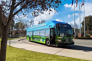
Golden Empire Transit is the operator of mass transportation in Bakersfield, California. There are 16 routes serving Greater Bakersfield, which includes both the City of Bakersfield and adjacent unincorporated communities. Since 2005, almost the entire bus fleet has been powered by compressed natural gas. In 2021, 5 hydrogen buses were added to the fleet, with an additional 5 planned for purchase in the future. In 2023, the system had a ridership of 3,531,400, or about 11,400 per weekday as of the third quarter of 2024.
Mill Creek is a linear park located in Bakersfield, California. It runs along the Kern Island Canal between Golden State Avenue and California Avenue in downtown, although there is a gap between 19th Street and the BNSF railroad yard. The center of the park is Central Park, the only park in downtown. The park contains a lake with spray fountains and the “Mill Creek” bridge. It is also home to the Bakersfield Museum of Art and the Bakersfield Community House.

Kern County’s transportation system was quoted as the “unseen industry.” Located at the southern end of the San Joaquin Valley, the county is at a prime location to ship goods west to the central coast, south to ports in Los Angeles, and east to corridors that connect to the rest of the country. It is also on major corridors that link to all northern points.

Downtown is the central business district for Bakersfield, California. It contains several of the city's major theaters, sports complex, museums, and historical landmarks.
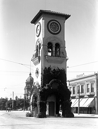
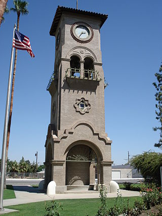
Beale Memorial Clock Tower is a clock tower located in Bakersfield, California. It was a gift to the city, built by Truxtun Beale in memory of his mother, Mary Edwards Beale, the wife of Edward Fitzgerald Beale. The original clock tower was built in the middle of the intersection of 17th Street and Chester Avenue, and was dedicated on April 4, 1904. The tower was designed by architect Clinton Day, while the clock itself was installed by Frank H. McConnell. The design was inspired by a clock tower that Truxtun Beale has seen while he was the U.S. ambassador to Spain.
Southwest Bakersfield is the southwest region of Bakersfield, California. It is roughly bounded by the Kern River to the north and Oak Street/Wible Road to the east. The other boundaries are the city limits themselves.
The Kern County Museum is a history museum located in Bakersfield, California. Its main focus is the history of Kern County. Pioneer Village, located on 16 acres (65,000 m2), contains over 50 original buildings from around the county, related to life in the late 19th century. Other features include: Lori Brock Children's Discovery Center, Black Gold exhibit, and Neon Plaza. The museum is accredited by the American Alliance of Museums.
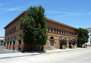
The Tevis Block, also known as the Kern County Land Company Building, is a historic office building in Bakersfield, California. The structure was placed on the National Register of Historic Places (NRHP) on March 29, 1984.
Bakersfield Department of Economic and Community Development is a department of the city of Bakersfield, California, United States. It is responsible for attracting new businesses and visitors to the city. It also acts as a liaison between businesses and the city government. In addition, the department is also responsible for encouraging redevelopment. It also distributes federal/state redevelopment and housing grants. The department is also in charge of the Bakersfield Register of Historic Places, which is a local register of historic places in the city.
The Department of Recreation and Parks is a department of the city of Bakersfield, California. It is responsible for the maintenance of the city's lands which include: parks, natural preserves, and streetscapes. It also runs recreational programs throughout the year at various locations throughout the city. The department also runs the Bakersfield Ice Sports Center and McMurtrey Aquatic Center. Although there are incorporated areas in the northwest, the city does not have any parks in that region. They are instead maintained by the North of the River Recreation and Parks District. The department has been accredited by the Commission for Accreditation of Park and Recreation Agencies.
Gordon's Ferry is both a geographical location and a historic site in Bakersfield, California. It is located where China Grade Loop crosses the Kern River and meets with Alfred Harrell Highway in Northeast Bakersfield. It is named after a ferry that used to cross the river near the existing bridge. It was one of the only eastern crossings, until 1877, when the Jewett Avenue bridge was constructed farther west. It is California Historical Landmark #137.
Bakersfield provides a wide variety of arts and culture.
The Bakersfield and Kern Electric Railway was a streetcar company which operated between Bakersfield and Sumner, in California. Later, after Kern City was annexed by Bakersfield, the streetcar company operated completely in Bakersfield. The company was originally formed in 1887, under the name Bakersfield and Sumner Railroad. At its height, in 1915, the company operated five streetcar lines, totaling 10.5 miles (16.9 km). It also operated three feeder bus lines, one of the first companies in the nation to offer that type of service. Also, with the exception of one-way sections, the entire system was double tracked.
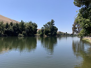
Hart Memorial Park is a large public park in Kern County, California. It is located just north of Bakersfield. The park is 370 acres (150 ha), and contains two lakes and three canals. It was named after County Supervisor John Hart, who spearheaded the project. Constructed between 1921 and 1936, it is the oldest section of the Kern River County Park.
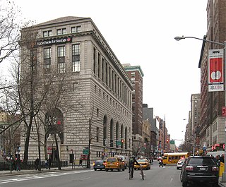
The Apple Bank Building, also known as the Central Savings Bank Building and 2100 Broadway, is a bank and residential building at 2100–2114 Broadway on the Upper West Side of Manhattan in New York City. Constructed as a branch of the Central Savings Bank, now Apple Bank, from 1926 to 1928, it occupies a trapezoidal city block bounded by 73rd Street to the south, Amsterdam Avenue to the east, 74th Street to the north, and Broadway to the west. The Apple Bank Building was designed by York and Sawyer in the Renaissance Revival and palazzo styles, patterned after an Italian Renaissance-style palazzo.


