Bakersfield Register of Historic Places and Areas of Historic Interest

Last updated

The Bakersfield Register of Historic Places and Areas of Historic Interest consist of buildings and sites designated by the City of Bakersfield, California, as significant historic resources. [1]

Contents

Bakersfield's historic preservation program operates on a voluntary basis. The city may not designate a property on its register without being affirmatively petitioned by the property owner requesting inclusion. [2] The program is overseen by a Historic Preservation Commission made up of citizens appointed by the City Council with special expertise and interest in historic preservation. [3]

In the first five years of the city's historic preservation program (1992-1997), 12 buildings were listed on the Bakersfield Register of Historic Places. In the more than 20 years thereafter, only three buildings and a cemetery have been added. [1] With only 16 sites on its local register (compared to more than 300 sites designated by the City of Fresno), Bakersfield has been criticized for its lack of focus on historic preservation. [4]

These listings represent local designations by the City of Bakersfield. In addition, five buildings in Bakersfield have been listed on the National Register of Historic Places (NRHP) and are also listed below. Of the five buildings listed on the NRHP, only the Jastro Building (also known as the Standard Oil Building) has been cross-designated on the Bakersfield Register of Historic Places. There are also four sites within the city that have been designated as California Historical Landmarks; two of these buildings no longer exist, and none of the state landmarks have been cross-designated on the Bakersfield Register of Historic Places.

A map displaying the locations of Bakersfield's designated historic places and areas of historic interest, as well as the four buildings listed on the NRHP and four sites listed as California Historical Landmarks, can be viewed by clicking "OpenStreetMap" in the template found to the right below.

Map all coordinates using: OpenStreetMap

Bakersfield Register of Historic Places

# [5] NameImageLocationDesignatedDescription
1The Hayden Building1622 19th Street
35°22′35″N119°01′15″W / 35.37651667°N 119.02081667°W / 35.37651667; -119.02081667 (Hayden Building)
2/12/92Second Renaissance Revival building built in 1904 by the Kern County Land Company; occupants have included the Hayden Furniture Company, the Ancient Order of United Workmen, Mrs. Andrews Dancing Hall, the Continental Hotel, and the Valley Office Supply Company, and the Spotlight Theatre and Cafe
2Woman's Club of Bakersfield2030 18th Street
35°22′31″N119°01′30″W / 35.375392°N 119.025005°W / 35.375392; -119.025005 (Women's Club)
2/12/92Colonial style building opened in 1921 [6]
3Frank Munzer House1701 F Street
35°22′28″N119°01′25″W / 35.374476°N 119.023629°W / 35.374476; -119.023629 (Frank Munzer House)
2/12/92Craftsman home built c. 1903 for Frank G. Munzer, Office Superintendent for the Kern County Land Company and a partner in the Breckenridge Lumber Company
4The Guild House1905 18th Street
35°22′31″N119°01′25″W / 35.375222°N 119.023740°W / 35.375222; -119.023740 (Guild House)
4/8/92Craftsman house built in 1908
5Colonial Apartments1701 B Street
35°22′28″N119°01′42″W / 35.374493°N 119.028283°W / 35.374493; -119.028283 (Colonial Apartments)
5/20/92
6The McGill Building1821-29 B Street
35°22′32″N119°01′42″W / 35.375617°N 119.028277°W / 35.375617; -119.028277 (McGill Building)
9/16/92
7 China Alley Alley between L & M and 21st & 22nd Streets
35°22′43″N119°00′58″W / 35.378735°N 119.015978°W / 35.378735; -119.015978 (China Alley)
9/16/92The historic center of Bakersfield's original Chinatown, occupied in the late 1800s by approximately 3,000 Chinese nationals brought to California for railroad construction
8Curran House222 Eureka Street
35°22′27″N119°00′05″W / 35.374292°N 119.001450°W / 35.374292; -119.001450 (Curran House)
2/1/93
9Standard Oil Building, aka the Jastro Building 2009-0726-CA-Bakersfield-JastroBuilding.jpg 1800 19th Street2/23/94Second Renaissance Revival office building built in 1917; also listed in 1983 on the National Register of Historic Places
10 Fox Theater 2009-0726-CA-Bakersfield-FoxTheater.jpg 2001 H Street
35°22′38″N119°01′17″W / 35.377343°N 119.021365°W / 35.377343; -119.021365 (Fox Theater)
8/24/94Spanish Colonial Revival theater designed by S. Charles Lee, opened in 1930, rebuilt 1953; remodeled after a 1952 earthquake with Art Moderne interior [7]
11Spencer House1321 N Street
35°22′11″N119°00′51″W / 35.369715°N 119.014227°W / 35.369715; -119.014227 (Spencer House)
11/8/95Queen Anne/Eastlake house built in 1890 at corner of 14th and Chester; moved to present location in 1928
12Hugh Curran home1910 Alta Vista Drive
35°23′22″N118°59′43″W / 35.389324°N 118.995260°W / 35.389324; -118.995260 (Hugh Curran home)
7/16/97
13Jastro House1811 20th Street
35°22′38″N119°01′21″W / 35.377123°N 119.022588°W / 35.377123; -119.022588 (Jastro House)
3/9/05Two-story Gothic Victorian Cottage owned by Henry Jastro, head of the Kern County Land Company and Chairman for 24 years of the Kern County Board of Supervisors [8]
14 Kern County Chamber of Commerce Building Kern County Chamber of Commerce Building South Entrance.jpg 3801 Chester Avenue
35°23′39″N119°01′08″W / 35.394198°N 119.018817°W / 35.394198; -119.018817 (Kern Co. Chamber of Commerce Bldg.)
3/12/08Built 1927-28 with Beaux Arts, Mission Revival, and Arts and Crafts influences; now part of the Kern County Museum
15Union CemeteryKing and Potomac Streets
35°21′53″N118°59′39″W / 35.364662°N 118.994178°W / 35.364662; -118.994178 (Union Cemetery)
10/27/12Pioneers Section; burial place of local historic figures and Bakersfield's founding fathers [9]
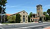
16Mt. Zion Missionary Baptist Church825 California Avenue
35°22′06″N119°00′40″W / 35.368375°N 119.011014°W / 35.368375; -119.011014 (Mt. Zion Missionary Baptist Church)
3/8/17African-American Baptist church built c. 1926; congregation active in Bakersfield since 1886 [10]

Bakersfield Areas of Historic Interest

NameImageLocationDesignatedDescription
James McKamy House2124 E Street
35°22′44″N119°01′28″W / 35.378800°N 119.024496°W / 35.378800; -119.024496 (James McKamy House)
3/16/10Single-story wood frame house
R.L. Brown House2128 E Street
35°22′44″N119°01′28″W / 35.378962°N 119.024388°W / 35.378962; -119.024388 (R.L. Brown House)
5/18/10

NRHP listings in Bakersfield

NameImageLocationDesignatedDescription
First Baptist Church 2009-0726-CA-Bakersfield-1stBaptist.jpg 1200 Truxtun Avenue
35°22′26″N119°00′54″W / 35.373889°N 119.015°W / 35.373889; -119.015 (First Baptist Church)
1/2/79Mission/Spanish Revival, Romanesque church built in 1931 [11]
Kern Branch, Beale Memorial Library, aka Baker Street Library 2009-0726-CA-Bakersfield-BakerLib.jpg 1400 Baker Street
35°23′00″N118°59′27″W / 35.383219°N 118.990729°W / 35.383219; -118.990729 (Baker Street Library)
4/1/81Classical Revival, Beaux-Arts library built 1913-15 [12]
Bakersfield Californian Building 2009-0726-CA-Bakersfield-Californian.jpg 1707 Eye Street
35°22′30″N119°01′10″W / 35.375°N 119.019444°W / 35.375; -119.019444 (Bakersfield Californian Building)
3/10/83Italian Renaissance Revival built 1926 as home of the newspaper, The Bakersfield Californian [13]
Jastro Building, aka Standard Oil Building 2009-0726-CA-Bakersfield-JastroBuilding.jpg 1800 19th Street
35°22′35″N119°01′18″W / 35.376389°N 119.021667°W / 35.376389; -119.021667 (Jastro Building)
9/22/83Second Renaissance Revival office building built in two sections in 1917 and 1921 [14]
Tevis Block, aka Kern County Land Company Building 2009-0726-CA-Bakersfield-TevisBlock.jpg 1712 19th Street
35°22′36″N119°01′14″W / 35.376667°N 119.020556°W / 35.376667; -119.020556 (Tevis Block)
3/29/84Second Renaissance Revival office building built in 1893; built by the Kern County Land Company [15]

California Historical Landmarks in Bakersfield

NumberNameImageLocationDescription
277 Garces Memorial Circle 2009-0726-CA-Bakersfield-GarcesCircle.jpg Chester Ave & 30th St.
35°23′13″N119°01′08″W / 35.386806°N 119.019023°W / 35.386806; -119.019023 (Garces Circle)
A traffic circle featuring a 1939 sculpture of Father Francisco Garces by John Palo-Kangas; it is located at the approximate site where in 1776 the Spanish Franciscan friar Francisco Garcés visited a Native American rancheria; Garcés named the location, San Miguel de los Noches por el Santa Príncipe; listed as a California Historical Landmark in 1937 [16]
382 Colonel Thomas Baker Memorial 2011 Bakersfield City Hall Baker Statue.JPG Bakersfield City Hall, 1501 Truxtun Ave.
35°22′24″N119°01′08″W / 35.373254°N 119.018952°W / 35.373254; -119.018952 (Col. Thomas Baker Memorial)
Memorial statue and marker in front of the Bakersfield City Hall South honoring Col. Thomas Baker who founded Bakersfield in 1863; listed as a California Historical Landmark in 1944 [17]
690 Site of the last home of Alexis Godey 414 19th St. W.
35°22′36″N119°00′23″W / 35.376620°N 119.006370°W / 35.376620; -119.006370 (Site of Alexis Godey home)
Home of Alexis Godey from 1883 to 1889; Godey was a guide for John C. Frémont's expedition through the area in 1843-44 and was honored for his services at the Battle of San Pasqual in 1846; listed as a California Historical Landmark in 1959 [18]
732Site of the home of Elisha StevensW. Columbus & Isle Verde Sts.
35°23′51″N119°00′21″W / 35.397383°N 119.005769°W / 35.397383; -119.005769 (Site of Elisha Stevens home)
Home of Elisha Stevens who in 1844 led the Murphy-Townsend wagon train from Iowa to Sutter's Fort; he became the first permanent European settler in the Bakersfield district, living there until his death 1887; listed as a California Historical Landmark in 1960 [19]

See also

Related Research Articles

The National Register of Historic Places (NRHP) is the United States federal government's official list of districts, sites, buildings, structures, and objects deemed worthy of preservation for their historical significance or "great artistic value". A property listed in the National Register, or located within a National Register Historic District, may qualify for tax incentives derived from the total value of expenses incurred in preserving the property.

<span class="mw-page-title-main">National Historic Landmark</span> Designation by the US government

A National Historic Landmark (NHL) is a building, district, object, site, or structure that is officially recognized by the United States government for its outstanding historical significance. Only some 2,500, or roughly three percent, of over 90,000 places listed on the country's National Register of Historic Places are recognized as National Historic Landmarks.

<span class="mw-page-title-main">California Historical Landmark</span> Buildings, structures, sites, or places in California determined to have historical significance

A California Historical Landmark (CHL) is a building, structure, site, or place in the U.S. state of California that has been determined to have statewide historical landmark significance.

<span class="mw-page-title-main">Havilah, California</span> Unincorporated community in California, United States

Havilah is an unincorporated community in Kern County, California. It is located in the mountains between Walker Basin and the Kern River Valley, 5 miles (8.0 km) south-southwest of Bodfish at an elevation of 3,136 feet (956 m).

<span class="mw-page-title-main">Ste. Genevieve National Historical Park</span> Historic district in Missouri, United States

The Ste. Genevieve National Historical Park, established in 2020, consists of part or the whole of the area of the Ste. Genevieve Historic District, which is a historic district encompassing much of the built environment of Ste. Genevieve, Missouri, United States. The city was in the late 18th century the capital of Spanish Louisiana, and, at its original location a few miles south, capital of French Louisiana as well. A large area of the city, including fields along the Mississippi River, is a National Historic Landmark District designated in 1960, for its historically French architecture and land-use patterns, while a smaller area, encompassing the parts of the city historically important between about 1790 and 1950, was named separately to the National Register of Historic Places in 2002.

<span class="mw-page-title-main">Los Angeles Historic-Cultural Monument</span> Heritage designation of the city of Los Angeles, California, U.S.

Los Angeles Historic-Cultural Monuments are sites which have been designated by the Los Angeles, California, Cultural Heritage Commission as worthy of preservation based on architectural, historic and cultural criteria.

<span class="mw-page-title-main">National Register of Historic Places listings in Kern County, California</span>

This is a list of the National Register of Historic Places listings in Kern County, California.

<span class="mw-page-title-main">First Baptist Church (Bakersfield, California)</span> Historic church in California, United States

The First Baptist Church, also known as the Bell Towers, is a historic church complex built in 1931 in Bakersfield, California. The church moved to a new campus in 1977 and the building presently used as an office building. The structure was placed on the National Register of Historic Places (NRHP) on January 2, 1979.

<span class="mw-page-title-main">Tevis Block</span> United States historic place

The Tevis Block, also known as the Kern County Land Company Building, is a historic office building in Bakersfield, California. The structure was placed on the National Register of Historic Places (NRHP) on March 29, 1984.

<span class="mw-page-title-main">Jastro Building</span> United States historic place

The Jastro Building, also known as the Standard Oil Building, is a historic office building in Bakersfield, California. The structure was placed on the National Register of Historic Places (NRHP) on September 22, 1983.

<span class="mw-page-title-main">César E. Chávez National Monument</span> U.S. National Monument in Keene, Kern County, California

César E. Chávez National Monument, also known as Nuestra Señora Reina de la Paz, is a 116-acre (47 ha) U.S. National Monument in Keene, Kern County, California, located about 32 miles away from Bakersfield, California. The property was the headquarters of the United Farm Workers (UFW), and home to César Chávez from the early 1970s until his death in 1993. Chávez's gravesite is located in the property's gardens along with that of his wife, Helen Fabela Chávez. Originally developed as a headquarters and worker housing area for a quarry, it served as a tuberculosis sanitarium in the early 1900s, until its acquisition by the UFW in the early 1970s.

<span class="mw-page-title-main">The Forty Acres</span> United States historic place

The Forty Acres, located in Delano, California, was the first headquarters of the United Farm Workers labor union. The union acquired the site of the compound in 1966, and the buildings were built in the ensuing years. The first building constructed on the property was a service station built in 1967, and several smaller service buildings were built soon afterward. The main building on the property, the Mission Revival styled Reuther Hall, was built from 1968 to 1969; the hall was named for United Auto Workers organizer Roy Reuther. A health care clinic and a retirement village were added to the property in the early 1970s.

<span class="mw-page-title-main">Kern Branch, Beale Memorial Library</span> United States historic place

The Baker Street Library, is a library located at 1400 Baker St. in Bakersfield, California. The library was constructed from 1913 to 1915 and replaced Bakersfield's original library building. Architect O. L. Clark designed the building in the Classical Revival style; the library is the only surviving building designed by Clark in Bakersfield. The library is designed as a central block with two wings at the east and west ends. The library's main entrance is located on the east wing; the entrance is a portico supported by columns and topped with a pediment and a frieze reading "PUBLIC LIBRARY". The ornate interior decorations incorporate classical and Renaissance themes.

<span class="mw-page-title-main">Glendale Register of Historic Resources and Historic Districts</span>

The Glendale Register of Historic Resources and Historic Districts consist of buildings, structures, bridges, statues, trees, and other objects designated by the City of Glendale, California, as significant historic resources or historic districts.

References

  1. 1 2 "Bakersfield Register of Historic Places". City of Bakersfield. Retrieved July 8, 2019.
  2. Douglas McIsaac, Bakersfield Community Development Director (September 16, 2014). "Memorandum to Bakersfield Legislative and Litigation Committee" (PDF). Retrieved July 8, 2019.
  3. "Historic Preservation". City of Bakersfield. Retrieved July 8, 2019.
  4. Steven Mayer (May 10, 2014). "Downtown building may be fostering changes". The Bakersfield Californian.
  5. Numbers are as designated by the City of Bakersfield. Blue color notes properties listed on the National Register of Historic Places.
  6. Lisa Kimble (December 26, 2014). "Named After: Woman's Club of Bakersfield". The Bakersfield Californian.
  7. "The Historical Fox Theater". The Bakersfield Fox. Retrieved July 8, 2019.
  8. Lisa Kimble (June 30, 2015). "Named After: Jastro House". The Bakersfield Californian.
  9. "Historic Union Cemetery". The Bakersfield Californian. March 28, 2014. Retrieved July 8, 2019.
  10. "Can we get an amen: Mt. Zion marks 130 years". The Bakersfield Californian. November 15, 2016. Retrieved July 8, 2019.
  11. Wilbur Rickett (September 14, 1978). "NRHP Inventory-Nomination Form for First Baptist Church" . Retrieved July 8, 2019.
  12. "Gallery of photos of the Baker Street Library". National Park Service. Retrieved July 8, 2019.
  13. John Carroll Teves (August 9, 1982). "NRHP Inventory-Nomination Form for The Bakersfield Californian Building" . Retrieved July 8, 2019.
  14. "Gallery of photos of Jastro Building". National Park Service. Retrieved July 8, 2019.
  15. "Gallery of photos of Tevis Block/Kern County Land Co. Building". National Park Service. Retrieved July 8, 2019.
  16. "Garces Circle". California State Parks, Office of Historic Preservation. Retrieved July 8, 2019.
  17. "Colonel Thomas Baker Memorial". California State Parks, Office of Historic Preservation. Retrieved July 8, 2019.
  18. "Site of the Last Home of Alexis Godey". California State Parks, Office of Historic Preservation. Retrieved July 8, 2019.
  19. "Site of the Home of Elisha Stevens". California State Parks, Office of Historic Preservation. Retrieved July 8, 2019.