Related Research Articles

California is a U.S. state on the western coast of North America. Covering an area of 163,696 sq mi (423,970 km2), California is among the most geographically diverse states. The Sierra Nevada, the fertile farmlands of the Central Valley, and the arid Mojave Desert of the south are some of the major geographic features of this U.S. state. It is home to some of the world's most exceptional trees: the tallest, most massive, and oldest. It is also home to both the highest and lowest points in the 48 contiguous states. The state is generally divided into Northern and Southern California, although the boundary between the two is not well defined. San Francisco is decidedly a Northern California city and Los Angeles likewise a Southern California one, but areas in between do not often share their confidence in geographic identity. The US Geological Survey defines the geographic center of the state at a point near North Fork, California.

Modoc County is a county in the far northeast corner of the U.S. state of California. Its population is 8,700 as of the 2020 census, down from 9,686 from the 2010 census. This makes it California's third-least populous county. The county seat and only incorporated city is Alturas. Previous county seats include Lake City and Centerville. The county borders Nevada and Oregon.

Siskiyou County is a county located in the northernmost part of the U.S. state of California. As of the 2020 census, the population was 44,076. Its county seat is Yreka and its highest point is Mount Shasta. It falls within the Cascadia bioregion.

Klamath Falls is a city in, and the county seat of, Klamath County, Oregon, United States. The city was originally called Linkville when George Nurse founded the town in 1867. It was named after the Link River, on whose falls the city was sited. The name was changed to Klamath Falls in 1893. The population was 21,813 at the 2020 census. The city is on the southeastern shore of the Upper Klamath Lake. It is located 80 miles (130 km) east of Medford, 250 miles (400 km) northwest of Reno, and approximately 10 miles (16 km) north of the California–Oregon border.

The Modoc are an Indigenous American people who historically lived in the area which is now northeastern California and central Southern Oregon. Currently, they include two federally recognized tribes, the Klamath Tribes in Oregon and the Modoc Tribe of Oklahoma, now known as the Modoc Nation.

Modoc Point is a cliff on the east shore of Upper Klamath Lake, in Klamath County, Oregon, United States, approximately 15 miles north of Klamath Falls on U.S. Route 97. It is part of the larger cliff known as Modoc Rim or Modoc Ridge.
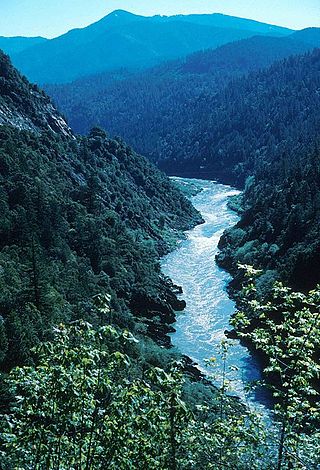
The Klamath River flows 257 miles (414 km) through Oregon and northern California in the United States, emptying into the Pacific Ocean. By average discharge, the Klamath is the second largest river in California after the Sacramento River. It drains an extensive watershed of almost 16,000 square miles (41,000 km2) that stretches from the arid country of south-central Oregon to the temperate rainforest of the Pacific coast. Unlike most rivers, the Klamath begins in the high desert and flows toward the mountains – carving its way through the rugged Cascade Range and Klamath Mountains before reaching the sea. The upper basin, today used for farming and ranching, once contained vast freshwater marshes that provided habitat for abundant wildlife, including millions of migratory birds. Most of the lower basin remains wild, with much of it designated wilderness. The watershed is known for this peculiar geography, and the Klamath has been called "a river upside down" by National Geographic magazine.

The Pit River is a major river draining from northeastern California into the state's Central Valley. The Pit, the Klamath and the Columbia are the only three rivers in the U.S. that cross the Cascade Range.

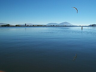
The Williamson River of south-central Oregon in the United States is about 100 miles (160 km) long. It drains about 3,000 square miles (7,800 km2) east of the Cascade Range. Together with its principal tributary, the Sprague River, it provides over half the inflow to Upper Klamath Lake, the largest freshwater lake in Oregon. The lake's outlet is the Link River, which flows into Lake Ewauna and the Klamath River.

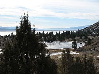
Lost River begins and ends in a closed basin in northern California and southern Oregon in the United States. The river, 60 miles (97 km) long, flows in an arc from Clear Lake Reservoir in Modoc County, California, through Klamath County, Oregon, to Tule Lake in Siskiyou County, California. About 46 mi (74 km) of Lost River are in Oregon, and 14 miles (23 km) are in California.

The Shasta–Trinity National Forest is a federally designated forest in northern California, United States. It is the largest National Forest in California and is managed by the U.S. Forest Service. The 2,210,485 acre forest encompasses five wilderness areas, hundreds of mountain lakes and 6,278 miles (10,103 km) of streams and rivers. Major features include Shasta Lake, the largest man-made lake in California and Mount Shasta, elevation 14,179 feet (4,322 m).

Tule Lake is an intermittent lake covering an area of 13,000 acres (53 km2), 8.0 km (5.0 mi) long and 4.8 km (3.0 mi) across, in northeastern Siskiyou County and northwestern Modoc County in California, along the border with Oregon.
Lake Ewauna is a reservoir in Klamath Falls, Oregon. It is the headwaters of the Klamath River, fed by the Link River from Upper Klamath Lake. Its constant level throughout the year is controlled by the release of water from Keno Dam, 18 mi (29 km) south of the Link River's mouth on the reservoir. Dam and reservoir are elements of the Klamath River Hydroelectric Project.

Lower Klamath Lake is a lake in Siskiyou County, California. At one time it was connected to Upper Klamath Lake. It currently is used to hold overflow water for Klamath Project irrigation uses.

The Klamath Basin is the region in the U.S. states of Oregon and California drained by the Klamath River. It contains most of Klamath County and parts of Lake and Jackson counties in Oregon, and parts of Del Norte, Humboldt, Modoc, Siskiyou, and Trinity counties in California. The 15,751-square-mile (40,790 km2) drainage basin is 35% in Oregon and 65% in California. In Oregon, the watershed typically lies east of the Cascade Range, while California contains most of the river's segment that passes through the mountains. In the Oregon-far northern California segment of the river, the watershed is semi-desert at lower elevations and dry alpine in the upper elevations. In the western part of the basin, in California, however, the climate is more of temperate rainforest, and the Trinity River watershed consists of a more typical alpine climate.

Modoc National Wildlife Refuge is a National Wildlife Refuge of the United States located in northeastern California. It is next to the South Fork of the Pit River in Modoc County, southeast of Alturas.

Modoc Point is an unincorporated community in Klamath County, Oregon, United States on U.S. Route 97 on the shore of Upper Klamath Lake.
The Fandango Pass is a gap in the Warner Mountains of Modoc County, California, USA. Located in the Modoc National Forest, its elevation is 6,135 feet (1,870 m) above sea level. It is approximately 5 mi (8.0 km) southwest of Fort Bidwell.

Lake Modoc is a former lake in California and Oregon, in the location of present-day Upper Klamath Lake, Lower Klamath Lake and Tule Lake. It existed during the Pliocene and Pleistocene epochs, its formation probably influenced by volcanism and faulting. The bed of the former lake had plentiful resources for early humans, and today it is used for agriculture.
References
- 1 2 U.S. Geological Survey Geographic Names Information System: Keuchishkeni, California
- ↑ Hodge, Frederick Webb (ed.). Handbook of American Indians, North of Mexico. p. 676. Retrieved December 9, 2020.
- ↑ U.S. Geological Survey Geographic Names Information System: Lower Klamath Lake
Municipalities and communities of Modoc County, California, United States | ||
|---|---|---|
| City |  | |
| CDPs | ||
| Unincorporated communities | ||
| Indian reservations | ||
| Former settlements | ||
| | This Modoc County, California-related article is a stub. You can help Wikipedia by expanding it. |