Kafarakab is the francophone spelling of the name of a village in the mountains of Lebanon. In Arabic, it means the home of the hawk. The village, which is located in the Matn District of the Mount Lebanon Governorate, is of particular significance because it is one of the various historic points of origin of the Maalouf family. It was founded c. 1560 AD when three families of the Maalouf clan, living at the time across the valley in the village of Mhaydse, received permission from the ruling emir to establish the village. The family history is traced back to the beginnings of Christianity in the Middle East beginning with the Ghassanid tribe, which converted to Christianity nearly 2,000 years ago. The family name is now widespread worldwide.

Al-Nabi Shayth, is a village in the Valley of Beqa' and District of Ba'albek in Lebanon. The village was called by that name because it is considered to contain the burial-site of Seth the son of Adam. A mosque was built on the burial site and it contains the grave of Seth inside the mosque. The village is also the hometown of Abbas al-Musawi, who was a leader of Hezbollah, and an influential Twelver Shi'ite cleric. The village of Al-Nabi Sheeth is predominantly inhabited by people with the surnames Helbawi, Al-Moussawi, Hazimeh and Chokr.

Haret Hreik is a mixed Shia and Maronite Christian municipality, in the Dahieh suburbs, south of Beirut, Lebanon. It is part of the Baabda District. Once an agricultural village, Haret Hreik lost its rural identity due to the wave of refugees from Southern Lebanon who settled in the town and made it another urban neighborhood of Dahieh.

Aley is a district (qadaa) in Mount Lebanon, Lebanon, to the south-east of the Lebanon's capital Beirut. The capital is Aley. Aley city was previously known as the "bride of the summers" during the 1960 and 1970s, when Aley and neighboring Bhamdoune were attractive tourist locations for Lebanese emigres and local Lebanese
Kfarsghab is a village located in the Zgharta District in the North Governorate of Lebanon. It is situated in the Valley of Qadisha, which is considered a holy and spiritual place in Eastern Christianity. The main religion of its residents is Maronite Catholicism.
Bishmizzine, or Bishmezzine, Bechmezzine, Beshmizzine, Bishmezzine, thought to be neo-Assyrian, is a Greek Orthodox village, in the Koura district of the North Governorate of Lebanon. It is about 275 meters above sea level. Bishmizzine borders the villages of Afisdeeq, Kfar-Hazir, Amyoun, Fi', and B'terram.

Abbas Ahmad Atwi is a Lebanese football coach and former player who is the assistant manager of Lebanese Premier League club Nejmeh.
Hazmieh is a city in Mount Lebanon Governorate of Lebanon, and a suburb of Beirut, part of Greater Beirut.
Morh Kfarsghab is a village located in the Zgharta District in the North Governorate of Lebanon.

Mansourieh, also known by various spellings, including: el-Mansourieh, Mansouriyeh, Mansouriyet el-Matn, and el-Mansouria is a town in the Matn District of the Mount Lebanon Governorate, in Lebanon. This place holds significant historical importance due to the presence of well-preserved archaeological remains, specifically a Roman aqueduct.

The Green Party of Lebanon is a Lebanese green political party. Founded in August 2008, the green party advocates environmental protection, sustainable development, and human rights in Lebanon. It is the first Lebanese party to focus primarily on Green politics.

The Mount Lebanon Mutasarrifate was one of the Ottoman Empire's subdivisions following the Tanzimat reform. After 1861, there existed an autonomous Mount Lebanon with a Christian Mutasarrif (governor), which had been created as a homeland for the Maronites under European diplomatic pressure following the 1860 Druze–Maronite conflict. The Maronite Catholics and the Druze founded modern Lebanon in the early eighteenth century, through the ruling and social system known as the "Maronite-Druze dualism" in Mount Lebanon.

The Rafik Hariri University Hospital – formerly known as Beirut Governmental University Hospital (BGUH) – is the largest Lebanese public hospital, located on the outskirts of southern Beirut. The hospital's main building has a maximal capacity of 544 hospital beds; it comprises a total of seven floors with three annex buildings a 50 bed hotel and four villas hosting staff dormitories, outpatient clinics and administrative services. The hospital is affiliated with the Lebanese University.
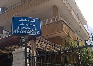
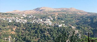
Kfaraakka also spelled Kferaakka is a village in the Koura District of Lebanon. It covers an area of 5.6 million square meters with an estimated population of 3,500. It had a population of 1,196 in 1953.
Mitrit is a mixed Shia Muslim and Maronite village in the Koura District, Lebanon.

Ghabat is a village in Lebanon located in the Jurd area of the district of Byblos in the Mount Lebanon region, about 74 kilometres northeast of Beirut. Its inhabitants are predominantly Maronite Catholics.
Mazraat es-Siyed is a mountainous village in the highlands of the Byblos District in the Keserwan-Jbeil Governorate, Lebanon. The town is 58 kilometres (36 mi) away from Beirut, and stands at an elevation of 1,250 m (4,100 ft) above sea level.
The War of Brothers was a period of violent armed clashes between rivals Amal and Hezbollah, Lebanon's main Shiite militia movements, during the final stages of the Lebanese Civil War. The fighting broke out in April 1988 and proceeded intermittently in three phases over the following years until the signing of an agreement brokered by their respective foreign backers, Syria and Iran, in November 1990.
Kfar Hatta is a village located in the Sidon District of the South Governorate in Lebanon. It is located 8 kilometres east of Sidon.
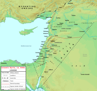
This article lists historical events that occurred between 601–700 in modern-day Lebanon or regarding its people.
 Kfarfakoud - a view from inside.
 Kfarfakoud (2003)- a picture taken from the place the village was located before 6th century A.D.
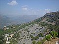 Stones telling the story.