
Himachal Pradesh is a state in the northern part of India. Situated in the Western Himalayas, it is one of the thirteen mountain states and is characterized by an extreme landscape featuring several peaks and extensive river systems. Himachal Pradesh is the northernmost state of India and shares borders with the union territories of Jammu and Kashmir and Ladakh to the north, and the states of Punjab to the west, Haryana to the southwest, Uttarakhand to the southeast and a very narrow border with Uttar Pradesh to the south. The state also shares an international border to the east with the Tibet Autonomous Region in China. Himachal Pradesh is also known as Dev Bhoomi, meaning 'Land of God' and Veer Bhoomi which means 'Land of Braves'.

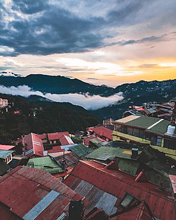
Shimla is the capital and the largest city of the Northern Indian state of Himachal Pradesh. In 1864, Shimla was declared as the summer capital of British India. After independence, the city became the capital of Punjab and was later made the capital city of Himachal Pradesh. It is the principal commercial, cultural and educational centre of the state. It was the capital city in exile of British Burma from 1942 to 1945.
Tashigang is a village near an ancient monastery in the state of Himachal Pradesh, India. It is a settlement in Kinnaur and is located in the Sutlej river valley near the India-Tibet border. National Highway 22(5New) connects Khab with state capital Shimla. Below Tashigangis flows the Sutlej river, which originates from Mansarovar Lake in Tibet. The villages of Nako and Khab are nearby.

The Lahaul and Spiti district in the Indian state of Himachal Pradesh consists of the two formerly separate districts of Lahaul tibetan Garzha and Spiti. The present administrative centre is Kyelang in Lahaul. Before the two districts were merged, Kardang was the capital of Lahaul, and Dhankar the capital of Spiti. The district was formed in 1960, and is the fourth least populous district in India . It is the least densely populated district of India, according to the Census of India 2011.

Mandi district is one of the central districts of Himachal Pradesh state in northern India. The town of Mandi is the headquarters of the district. The town has mythological and historical significance and boasts of a unique temple architecture. It is referred to as Chhoti Kashi as there are many ancient temples in the city and on the banks of river Beas.

Manali is a town in the Indian state of Himachal Pradesh. It is situated in the northern end of the Kullu Valley, formed by the Beas River. The town is located in the Kullu district, approximately 270 kilometres (170 mi) north of the state capital of Shimla and 544 kilometres (338 mi) northeast of the national capital of Delhi. With a population of 8,096 people recorded in the 2011 Indian census Manali is the beginning of an ancient trade route through Lahaul and Ladakh, over the Karakoram Pass and onto Yarkand and Hotan in the Tarim Basin of China. Manali is a popular tourist destination in India and serves as the gateway to the Lahaul and Spiti district as well as the city of Leh in Ladakh.

Kinnaur is one of the twelve administrative districts of the state of Himachal Pradesh in northern India. The district is divided into three administrative areas and has six tehsils. The administrative headquarters of the district is at Reckong Peo. The mountain peak of Kinnaur Kailash is found in this district. As of 2011, it is the second least populous district of Himachal Pradesh, after Lahaul and Spiti.

The state of Himachal Pradesh is spread over an area 55,673 km2 (21,495 sq mi) and is bordered by Jammu and Kashmir and Ladakh on the north, Punjab on the southwest, Haryana on the south, Uttarakhand on the southeast, a small border with Uttar Pradesh in the south, and Tibet on the east. Entire Himachal Pradesh lies in the mountainous Himalaya region, rich in natural resources.

Shipki La is a mountain pass and border post with a dozen buildings of significant size on the India-China border. The river Sutlej, which is called Langqên Zangbo in Tibet, enters India near this pass. A spur road on the Indian side rises to an altitude of 4,720 metres (15,490 ft) four km southwest of Shipki La.

Spiti Valley is a cold desert mountain valley located high in the Himalayas in the north-eastern part of the northern Indian state of Himachal Pradesh. The name "Spiti" means "The middle land", i.e. the land between Tibet and India.
The development of tribal areas in Himachal Pradesh is one of the major steps taken by the state government for its economic development. The border districts of Kinnaur, Lahaul, Spiti and the Pangi and Bharmour tehsils of Chamba districts are the major tribal areas of the state. They are located near the borders of Tibet and Indian States of Jammu and Kashmir. Other backward areas include Shillai in Sirmaur district, and deep cut-off valleys in the Kullu and upper stretches of Kangra districts. Due to poor accessibility, life in these areas had grown in isolation.

Kaza, also spelled Kaze, Karze, Karzey, is a town and the subdivisional headquarters of the remote Spiti Valley in the western Himalayas in the Lahaul and Spiti district of the northern Indian state of Himachal Pradesh. Spiti is a high altitude or cold desert having close similarities to the neighbouring Tibet and Ladakh regions in terms of terrain, climate and the Buddhist culture. Kaza, situated along the Spiti River at an elevation of 3,650 metres (11,980 ft) above mean sea level, is the largest township and commercial center of the Spiti valley.

The Western Himalayas refers to the western half of the Himalayas, stretching from Badakhshan in northeastern Afghanistan/southern Tajikistan, Pakistan through northwestern India. It is also known as the Punjab Himalayas. All five tributaries of the Indus River in Punjab originate from the Western Himalayas.

National Highway 5 (NH5), is a primary national highway in India, running from West to East, connecting Firozpur in Punjab to the Sino-Indian border at Shipki La. The highway passes through Moga, Jagraon, Ludhiana, Mohali, Chandigarh, Panchkula, Kalka, Solan, Shimla, Theog, Narkanda, Kumarsain, Rampur Bushahr and continues along the Sutlej River till its terminus near the Tibet border.
Tourism in Himachal Pradesh relates to tourism in the Indian state of Himachal Pradesh. This is popularly renowned for its Himalayan landscapes and popular hill-stations. Many outdoor activities such as rock climbing, mountain biking, paragliding, ice-skating, trekking, rafting, and heli-skiing are popular tourist attractions in Himachal Pradesh.
Reo Purgyil, sometimes known as Leo Pargial and Leo Pargil, is a mountain peak at the southern end of the Zanskar Range in the Western Himalaya. It is located the border between Himachal Pradesh, India and Tibet.

National Highway 505, commonly called NH 505, is a national highway in India. It is a spur road of National Highway 5. NH-505 traverses the state of Himachal Pradesh in India. NH505 a high altitude road, covers Kinnaur and Lahaul and Spiti districts of Himachal Pradesh, mainly running along Spiti river in Spiti valley. The highway from Kaza to Gramphu remains closed for 6–9 months in a year due to heavy snowfall and closure of Kunzum La pass at an altitude of 4,550 m (14,930 ft).

Bhaba Pass, also known as Bhawa Pass, is a high mountain pass situated in the northern Indian state of Himachal Pradesh in the Indian Himalayas. It is located on the border of Kinnaur district and Lahaul and Spiti District, and borders Pin Valley National Park and the Rupi-Bhaba Wildlife Sanctuary.
The Parang River is an upstream tributary of the Sutlej River, that originates in the Indian state of Himachal Pradesh and ends in Himachal Pradesh again, but flows through Ladakh and Tibet before doing so. The origin of the river is near the Parang La pass in the Spiti subdistrict. After its circuitous journey, it joins the Spiti River near Sumdo and the combined river then joins Sutlej.
Kaurik is village in the Lahul and Spiti district, in Himachal Pradesh, India. It is in the valley of the Parang River before its confluence with the Spiti River. It is close to the border with Tibet. The Tibetan village on the opposite of the border is Tsurup Sumgyi.


