Khan al-Tujjar (Mount Tabor)

Last updated
Khan al-Tujjar
[خان التجار ]
Fair at Khan al-Tujjar.jpg
A fair at Khan al-Tujjar around 1850, by W. H. Bartlett
Khan al-Tujjar (Mount Tabor)
Former names Khan al-Tujjar (in Arabic)
Alternative namesThe Merchant's Caravansary [1] Suq al-Khan
General information
Type Caravanserai
Architectural style Ottoman
Location Mount Tabor, Israel
Coordinates 32°43′17.46″N35°24′40.67″E / 32.7215167°N 35.4112972°E / 32.7215167; 35.4112972 Coordinates: 32°43′17.46″N35°24′40.67″E / 32.7215167°N 35.4112972°E / 32.7215167; 35.4112972
Palestine grid 187/236
Completed1581

Khan al-Tujjar, lit. "Merchant's Caravanserai", also called Suq al-Khan, was a caravanserai in the Lower Galilee, Israel, opposite the entrance to Beit Keshet, now in ruins.

Contents

History

The khan or caravanserai was established near Mount Tabor by Grand Vizier Sinan Pasha around 1581. [2] [3] The reason given for its establishment was that the place was insecure for merchants and people on pilgrimage, and it was argued that if a khan was built, the place would become "inhabited and cultivated." [3]

The Turkish traveler Evliya Çelebi visited in 1649. He reported that:

"It is a square, perfect fortress, built of masonry in the midst of a large, verdant meadow. It has a circumference of six hundred paces. The garrison consists of a warden and 150 men. It has a 'double' iron gate facing north. Inside the fortress are between forty and fifty rooms for the garrison. ... Inside the fortress is the Mosque of Sinan Pasha, an artistically constructed work, with a lead roof, full of light. Its windows have light blue glass enamel fixed symmetrically with rock crystal and crystal(?). It measures eighty feet each side. The sanctuary has three graceful and lofty minarets—Praise be to the Creator, as if they were three young coquettish muezzins—and seven high domes. The wayfarers are lavishly given a loaf of bread and a tallow candle for each person, and a nosebag of barley for each horse—free of charge. On either side of the fortress is a caravanserai with eight shops." [4]

In the early 18th century [5] there was one period where the area seemed deserted, and there was no weekly marked. However, Western travellers still noted two buildings, one with a mosque and bath inside, and one which had been used for goods and cattle. [6]

In the early 1760s the Italian traveller Mariti visited the khan, and wrote that:

"...you arrive at El-Net-Tesgiar, or the Place of Merchants. I was very much struck with the elegance and magnificence of its walls. Incrusted with the most beautiful marble, which the hand of art has disposed with much taste [..] El-Net-Tesgiar is enlivened by a very flourishing commerce. A fair is held here every Monday, which is resorted to by merchants from various countries. It is well furnished with cloth, cattle, and provisions of every kind; and in this respect it is, indeed, not inferior to the richest markets in Europe. [7]

Pierre Jacotin marked the place as Kan Ouioun el Touggar on his map from 1799. [8] James Silk Buckingham visited the place in around 1816, and described how, on a Monday, they found four to five thousand people assembled around the Khan, in addition to numerous herds of cattle. [9]

Khan el Tujjar from the 1871-77 PEF Survey of Palestine Khan el Tujjar from the 1871-77 Palestine Exploration Fund Survey of Palestine.jpg
Khan el Tujjar from the 1871-77 PEF Survey of Palestine

In his Biblical Researches in Palestine , American scholar Edward Robinson described his visit in 1838, a day after the weekly Monday fair which had "drawn away from their home a large portion of the people of Nazareth". As Buckingham, he describes two large buildings, one a Khan, and one building looking more like a castle. [10]

Remains of the Khan, in 2014 Hanut Tgarim (4).jpg
Remains of the Khan, in 2014

In the mid-1850s, W. M. Thomson made a lively description of a market day there:

On Monday of each week a great fair is held at the khans, when, for a few hours, the scene is very lively and picturesque. These gatherings afford an excellent opportunity to observe Syrian manners, customs, and costumes, and to become acquainted with the character and quality of Syrian productions. Thousands of people assemble from all parts of the country, either to sell, trade or purchase. Cotton is brought in bales from Nablus; barley, and wheat, and sesamum, and Indian corn from Huleh, the Hauran, and Esdraelon. From Gilead and Bashan, and the surrounding districts, come horses and donkeys, cattle and flocks, with cheese, leben, semen, honey and similar articles. Then there are miscellaneous matters, such as chicken and eggs, figs, raisins, apples, melons, grapes and all sorts of fruits and vegetables in season. The pedlars open their packages of tempting fabrics, the jeweller is there with his trinkets; the tailor with his ready-made garments; the shoemaker with his stock, from rough, hairy sandals to yellow and red Morocco boots; the farrier is there with his tools, nails, and flat iron shoes, and drives a prosperous business for a few hours; and so does the saddler, with his coarse sacks and gaily-trimmed cloths. And thus it is with all the arts and occupations known to this people.... But long before sunset not a soul of this busy throng remains on the spot. All return home, or to take refuge in some neighbouring village. [11]

In 1875 Victor Guérin visited, and described and measured the two buildings. [12] In 1881, when the PEF Survey of Palestine described it, Khan al-Tujjar was no longer a working caravanserai, but a market was held there each Thursday. [13] They also noted that there was a well with a perennial supply by the Khan. [14]

See also

Related Research Articles

<span class="mw-page-title-main">Nahf</span> Local council

Nahf is an Arab town in the Northern District of Israel. It is located in between the lower and upper Galilee, about 23 kilometres (14 mi) east of Acre. In 2021 it had a population of 13,558. Archaeologists believe that the area was an important center for viticulture in the Hellenistic period and possibly the Early Bronze Age IB period.

<span class="mw-page-title-main">Khirbat Jiddin</span> Place in Acre, Mandatory Palestine

Khirbat Jiddin, known in the Kingdom of Jerusalem as Judin, was an Ottoman fortress in the western Upper Galilee, originally built by the Teutonic Order after 1220 as a crusader castle, 16 km northeast of the city of Acre, which at the time was the capital of the Kingdom of Jerusalem. The castle was destroyed by the Mamluk sultan Baibars sometime between 1268-1271 and lay in ruins until being rebuilt and expanded by the Arab ruler Zahir al-Umar as Qal'at Jiddin in the 1760s, only to be destroyed again around 1775 by Jazzar Pasha. The ruined fortress, known as Khirbat Jiddin, was later inhabited by the al-Suwaytat Bedouin tribe.

<span class="mw-page-title-main">Al-Manshiyya, Acre</span> Place in Acre, Mandatory Palestine

Al-Manshiyya, was a Palestinian village with a Muslim orphanage and a mosque known as the mosque of Abu 'Atiyya, which is still standing.

<span class="mw-page-title-main">Al-Tall, Acre</span> Village in Acre, Mandatory Palestine

Al-Tall, was a Palestinian village 14 km northeast of Acre in the British Mandate District of Acre. Depopulated as a result of military assault and capture during the 1947-1948 Civil War in Mandatory Palestine as part of Operation Operation Ben-Ami by the Carmeli Brigade of the Israel Defense Forces.

<span class="mw-page-title-main">Qalansawe</span> City in Israel

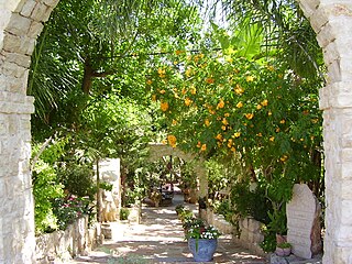
Qalansawe or Qalansuwa is an Arab city in the Central District of Israel. Part of the Triangle, in 2021 it had a population of 23,877.

<span class="mw-page-title-main">Al-Damun</span> Place in Acre, Mandatory Palestine

Al-Damun, was a Palestinian Arab village located 11.5 kilometres (7.1 mi) from the city of Acre that was depopulated during 1948 Arab-Israeli war. In 1945, the village had 1,310 inhabitants, most of whom were Muslim and the remainder Christians. Al-Damun bordered the al-Na'amin River, which the village's inhabitants used as a source of irrigation and drinking water from installed wells.

<span class="mw-page-title-main">Lubya</span> Place in Tiberias, Mandatory Palestine

Lubya, sometimes referred to as Lubia, Lubieh and Loubieh, was a Palestinian Arab town located ten kilometers west of Tiberias that was captured and destroyed by Israel during the 1948 Arab-Israeli War where its residents were forcefully evacuated and became refugees. Nearby villages included Nimrin to the north, Hittin to the northwest, and al-Shajara to the south; Each of those villages were also depopulated.

<span class="mw-page-title-main">Hamama</span> Place in Gaza, Mandatory Palestine

Hamama was a Palestinian town of over 5,000 inhabitants that was depopulated during the 1948 Arab-Israeli War. It was located 24 kilometers north of Gaza; its ruins are today in the north of the Israeli city of Ashkelon.

<span class="mw-page-title-main">Umm Khalid</span> Place in Tulkarm, Mandatory Palestine

Umm Khalid, also called Mukhalid, was a Palestinian village in the Tulkarm Subdistrict, 15 kilometers (9.3 mi) west of Tulkarm. It was an ancient site in the central coastline of what is now the city of Netanya, Israel.

<span class="mw-page-title-main">Ijzim</span> Place in Haifa, Mandatory Palestine

Ijzim was a village in the Haifa Subdistrict of British Mandate Palestine, 19.5 kilometers south of the city, that was depopulated during the 1948 Arab-Israeli war. Many of its Palestinian inhabitants ended up as refugees in Jenin after a group of Israeli Special Forces, composed of members of the Golani, Carmeli and Alexandroni Brigades, attacked the village in Operation Shoter on 24 July 1948.

<span class="mw-page-title-main">Jaljulia</span> Local council in Israel

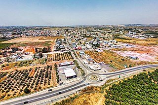
Jaljulia, officially also spelled Jaljulye, is an Arab town in Israel near Kfar Saba. In 2021 it had a population of 10,480.

<span class="mw-page-title-main">Yazur</span> Place in Jaffa, Mandatory Palestine

Yazur was a Palestinian Arab town located 6 kilometers (3.7 mi) east of Jaffa. Mentioned in 7th century BCE Assyrian texts, the village was a site of contestation between Muslims and Crusaders in the 12th-13th centuries.

<span class="mw-page-title-main">Qaqun</span> Place in Tulkarm, Mandatory Palestine

Qaqun was a Palestinian Arab village located 6 kilometers (3.7 mi) northwest of the city of Tulkarm at the only entrance to Mount Nablus from the coastal Sharon plain.

<span class="mw-page-title-main">Jit, Qalqilya</span> Municipality type D in Qalqilya, State of Palestine

Jit is a Palestinian town in the northern West Bank, located 10 kilometers (6.2 mi) west of Nablus. According to the Palestinian Central Bureau of Statistics, the village had a population of approximately 2,320 inhabitants in 2006.

<span class="mw-page-title-main">Zeita, Tulkarm</span> Municipality type D in Tulkarm, State of Palestine

Zeita is a Palestinian town in the Tulkarm Governorate in the western West Bank, located 11 kilometers North-east of Tulkarm. According to the Palestinian Central Bureau of Statistics, Zeita had a population of 2,852 inhabitants in 2007. 21.5% of the population of Zeita were refugees in 1997. The healthcare facilities for Zeita are designated as MOH level 2.

<span class="mw-page-title-main">Kawkab al-Hawa</span> Place in Baysan, Mandatory Palestine

Kawkab al-Hawa, is a depopulated former Palestinian village located 11 km north of Baysan. It was built within the ruins of the Crusader fortress of Belvoir, from which it expanded. The Crusader names for the Frankish settlement at Kawkab al-Hawa were Beauvoir, Belvoir, Bellum videre, Coquet, Cuschet and Coket. During Operation Gideon in 1948, the village was occupied by the Golani Brigade and depopulated.

<span class="mw-page-title-main">Rafidiya</span> Place in Nablus, State of Palestine

Rafidiya is a neighborhood in the western part of the Palestinian city of Nablus. It was a separate village until it was merged into the municipality in 1966. In 1961, Rafidiya had 923 inhabitants, rising to 1,200 in 1983.

<span class="mw-page-title-main">Sirin, Baysan</span> Place in Baysan, Mandatory Palestine

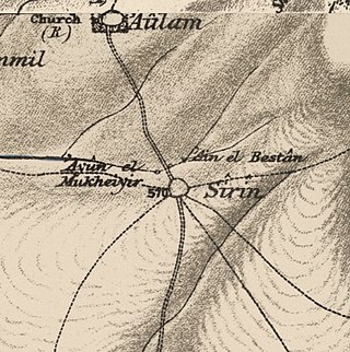
Sirin, was a Palestinian Arab village located 17 kilometers (11 mi) north of Beisan. The village was depopulated and destroyed in 1948. Only the village cemetery and one house remain standing, along with the remains of a mosaic pavement and a vaulted spring dating to the Byzantine period. Mentioned in historical documents, the 1596 census indicated it had 45 households; by 1945, the number of inhabitants had risen to 810.

<span class="mw-page-title-main">Biriyya</span> Place in Safad, Mandatory Palestine

Biriyya was a Palestinian Arab village in the Safad Subdistrict. It was depopulated during the 1947–1948 Civil War in Mandatory Palestine on May 2, 1948, by The Palmach's First Battalion of Operation Yiftach. It was located 1.5 kilometres (0.9 mi) northeast of Safad. Today the Israeli moshav of Birya includes the village site.

<span class="mw-page-title-main">Jisr el-Majami</span> Bridge over the Jordan river

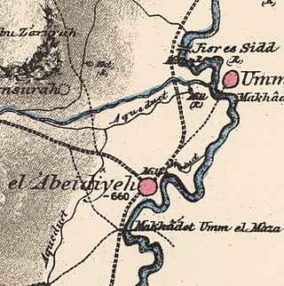
Jisr el-Majami or Jisr al-Mujamieh is an ancient stone bridge, possibly of Roman origin, over the Jordan River on the border between Israel and Jordan. The name is derived from the bridge's location 200 m (660 ft) south of the confluence of the Yarmouk and Jordan rivers.

References

  1. Palmer, 1881, p. 128
  2. Khan al-Tujjar Archived 2012-04-26 at the Wayback Machine Archnet Digital Library.
  3. 1 2 Sharon, 1999, p. 230
  4. Stephan, 1937, pp.84–85
  5. Noted between 1700-1723, see Robinson and Smith, 1841, vol 3, p. 19
  6. Egmont and Heyman, 1759, vol 2, p.27
  7. Mariti, 1792, vol 1, p. 357
  8. Karmon, 1960, p. 167 Archived 2019-12-22 at the Wayback Machine
  9. Buckingham, 1821, pp. 456, 457, 458
  10. Robinson and Smith, 1841, vol 3, p. 236
  11. Thomson, 1859, vol 2, pp. 152-153. Also cited in Schölch, 2003, p. 147
  12. Guérin, 1880, pp. 381 -382
  13. Conder and Kitchener, 1881, SWP I, pp. 394-396
  14. Conder and Kitchener, 1881, SWP I, p. 379

Bibliography