Related Research Articles

A levee, dike, dyke, embankment, floodbank, or stop bank is an elevated ridge, natural or artificial, alongside the banks of a river, often intended to protect against flooding of the area adjoining the river. It is usually earthen and often runs parallel to the course of a river in its floodplain or along low-lying coastlines.

A swamp is a forested wetland. Swamps are considered to be transition zones because both land and water play a role in creating this environment. Swamps vary in size and are located all around the world. The water of a swamp may be fresh water, brackish water, or seawater. Freshwater swamps form along large rivers or lakes where they are critically dependent upon rainwater and seasonal flooding to maintain natural water level fluctuations. Saltwater swamps are found along tropical and subtropical coastlines. Some swamps have hammocks, or dry-land protrusions, covered by aquatic vegetation, or vegetation that tolerates periodic inundation or soil saturation. The two main types of swamp are "true" or swamp forests and "transitional" or shrub swamps. In the boreal regions of Canada, the word swamp is colloquially used for what is more formally termed a bog, fen, or muskeg. Some of the world's largest swamps are found along major rivers such as the Amazon, the Mississippi, and the Congo.

Lake Pontchartrain is an estuary located in southeastern Louisiana in the United States. It covers an area of 630 square miles (1,600 km2) with an average depth of 12 to 14 feet. Some shipping channels are kept deeper through dredging. It is roughly oval in shape, about 40 miles (64 km) from west to east and 24 miles (39 km) from south to north.

The Sacramento–San Joaquin River Delta, or California Delta, is an expansive inland river delta and estuary in Northern California. The delta is formed at the western edge of the Central Valley by the confluence of the Sacramento and San Joaquin rivers and lies just east of where the rivers enter Suisun Bay, which flows into San Francisco Bay, then the Pacific Ocean via San Pablo Bay. The Delta is recognized for protection by the California Bays and Estuaries Policy. Sacramento–San Joaquin Delta was designated a National Heritage Area on March 12, 2019. The city of Stockton is located on the San Joaquin River at the eastern edge of the delta. The total area of the Delta, including both land and water, is about 1,100 square miles (2,800 km2). Its population is around 500,000.

The Mississippi River Delta is the confluence of the Mississippi River with the Gulf of Mexico in Louisiana, southeastern United States. The river delta is a three-million-acre area of land that stretches from Vermilion Bay on the west, to the Chandeleur Islands in the east, on Louisiana's southeastern coast. It is part of the Gulf of Mexico and the Louisiana coastal plain, one of the largest areas of coastal wetlands in the United States. The Mississippi River Delta is the 7th largest river delta on Earth (USGS) and is an important coastal region for the United States, containing more than 2.7 million acres of coastal wetlands and 37% of the estuarine marsh in the conterminous U.S. The coastal area is the nation's largest drainage basin and drains about 41% of the contiguous United States into the Gulf of Mexico at an average rate of 470,000 cubic feet per second.

The wetlands of Louisiana are water-saturated coastal and swamp regions of southern Louisiana, often called "Bayou".
The Comunidades of Goa are a form of land association developed in Goa, India, where land-ownership is collectively held, but controlled by the male descendants of those who claimed to be the founders of the village, who in turn mostly belonged to upper caste groups. Documented by the Portuguese as of 1526, it was the predominant form of landholding in Goa prior to 1961. In form, it is similar to many other rural agricultural peoples' form of landholding, such as that of pre-Spanish Bolivia and the Puebloan peoples now in the Southwestern United States, identified by Karl Marx as the dualism of rural communities: the existence of collective land ownership together with private production on the land.

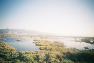
Located in northern California, the Suisun Marsh has been referred to as the largest brackish water marsh on west coast of the United States of America. The marsh land is part of a tidal estuary, and subject to tidal ebb and flood. The marsh is home to many species of birds and other wildlife, and is formed by the confluence of the Sacramento and San Joaquin rivers between Martinez and Suisun City, California and several other smaller, local watersheds. Adjacent to Suisun Bay, the marsh is immediately west of the legally defined Sacramento-San Joaquin Delta as well as part of the San Francisco Bay estuary.
Reclamation districts are a form of special-purpose districts in the United States which are responsible for reclaiming and/or maintaining land that is threatened by permanent or temporary flooding for agricultural, residential, commercial, or industrial use. The land is reclaimed by removing and/or preventing water from returning via systems of levees, dikes, drainage ditches, and pumps.

The Bonnet Carré Crevasse (1871) was one of several levee breaches in the Bonnet Carré area in the mid-to-late 19th century. Bonnet Carré was approximately 31 miles (50 km) from New Orleans, Louisiana.
St. Cruz or Santa Cruz is a village located next to the city of Panaji, capital of the Indian state of Goa. It is located on the island of Tiswadi, one of the talukas in the state of Goa.

The Columbia Slough is a narrow waterway, about 19 miles (31 km) long, in the floodplain of the Columbia River in the U.S. state of Oregon. From its source in the Portland suburb of Fairview, the Columbia Slough meanders west through Gresham and Portland to the Willamette River, about 1 mile (1.6 km) from the Willamette's confluence with the Columbia. It is a remnant of the historic wetlands between the mouths of the Sandy River to the east and the Willamette River to the west. Levees surround much of the main slough as well as many side sloughs, detached sloughs, and nearby lakes. Drainage district employees control water flows with pumps and floodgates. Tidal fluctuations cause reverse flow on the lower slough.
Lakes and tanks in the metropolitan area of Greater Bangalore and the district of Bangalore Urban are reservoirs of varying sizes constructed over a number of centuries by various empires and dynasties for rainwater harvesting. Historically, these reservoirs were primarily either irrigation tanks or for the water supply, with secondary uses such as bathing and washing. The need for creating and sustaining these man-made dammed freshwater reservoirs was created by the absence of a major river nearby coupled with a growing settlement. As Bangalore grew from a small settlement into a city, both of the primary historical uses of the tanks changed. Agricultural land witnessed urbanization and alternate sources of water were provisioned, such as through borewells, piped reservoir water and later river water from further away.

Flood management describes methods used to reduce or prevent the detrimental effects of flood waters. Flooding can be caused by a mix of both natural processes, such as extreme weather upstream, and human changes to waterbodies and runoff. Flood management methods can be either of the structural type and of the non-structural type. Structural methods hold back floodwaters physically, while non-structural methods do not. Building hard infrastructure to prevent flooding, such as flood walls, is effective at managing flooding. However, it is best practice within landscape engineering to rely more on soft infrastructure and natural systems, such as marshes and flood plains, for handling the increase in water.
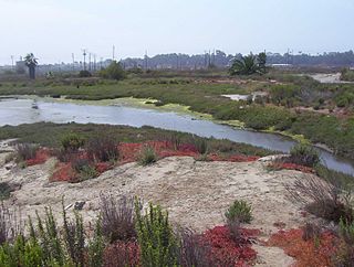
Los Cerritos Wetlands is located in both Los Angeles County and Orange County in the cities of Long Beach, California, and Seal Beach, California. The San Gabriel River, historically and currently flows through the Los Cerritos Wetlands Complex.

Agara lake is an 80-acre lake located in Agara, Bangalore. It is part of the Varthur lake series. Madiwala Lake is upstream while Bellandur Lake is downstream. Inter-lake connections have seen fragmentation and urbanisation.

Coastal erosion in Louisiana is the process of steady depletion of wetlands along the state's coastline in marshes, swamps, and barrier islands, particularly affecting the alluvial basin surrounding the mouth of the Mississippi River. In the last century, coastal Louisiana has lost an estimated 4,833 square kilometers (1,866 sq mi) of land, approximately the size of Delaware's land area. Coast wide rates of wetland change have varied from −83.5 square kilometers (−32.2 sq mi) to −28.01 square kilometers (−10.81 sq mi) annually, with peak loss rates occurring during the 1970's. One consequence of coastal erosion is an increased vulnerability to hurricane storm surges, which affects the New Orleans metropolitan area and other communities in the region. The state has outlined a comprehensive master plan for coastal restoration and has begun to implement various restoration projects such as fresh water diversions, but certain zones will have to be prioritized and targeted for restoration efforts, as it is unlikely that all depleted wetlands can be rehabilitated.
Sedimentation enhancing strategies are environmental management projects aiming to restore and facilitate land-building processes in deltas. Sediment availability and deposition are important because deltas naturally subside and therefore need sediment accumulation to maintain their elevation, particularly considering increasing rates of sea-level rise. Sedimentation enhancing strategies aim to increase sedimentation on the delta plain primarily by restoring the exchange of water and sediments between rivers and low-lying delta plains. Sedimentation enhancing strategies can be applied to encourage land elevation gain to offset sea-level rise. Interest in sedimentation enhancing strategies has recently increased due to their ability to raise land elevation, which is important for the long-term sustainability of deltas.
Neura is a village located in the Tiswadi taluka of Goa, India. The village boasts a historical heritage tracing back to the era of the Kadambas of Goa and is known for its collection of villas and mansions. During the reign of the Kadamba dynasty, the village was a bustling centre, primarily due to its Naval quarters. It was also a center for learned Brahmin-Sinais.
The Maurya dynasty ruled the coastal Konkan region in present-day Goa and Maharashtra states of India, between the 4th and the 7th centuries. Their capital was Puri, which is variously identified as Gharapuri (Elephanta), Salsette, or Rajapuri. The dynasty is known only from a few records, and there is very little clarity on its genealogy, chronology, territory, administration and political status.
References
- ↑ Sangeeta M. Sonak 2013, p. 33.
- ↑ N. Shyam Bhat & Nagendra Rao 2013, p. 254.
- ↑ Sangeeta M. Sonak 2013, p. 67.
Bibliography
- Sangeeta M. Sonak (2013). Khazan Ecosystems of Goa: Building on Indigenous Solutions to Cope with Global Environmental Change. Springer. ISBN 9789400772021.
- N. Shyam Bhat; Nagendra Rao (2013). "History of Goa with Special Reference to its Feudal Features". Indian Historical Review. 40 (2). doi:10.1177/0376983613499680. S2CID 145048379.