Sikar is a city and municipal council in the Sikar district of the state of Rajasthan in India. It is the administrative headquarters of the Sikar district. It is largest city of the Shekhawati region, which consists of Sikar, Churu and Jhunjhunu. After Kota, Sikar is one of the major hubs for private coaching in the country for competitive public examination preparations and has a number of engineering and medical coaching institutes.

Shekhawati is a semi-arid historical region located in the northeast part of Rajasthan, India. The region was ruled by Shekhawat Rajputs. Shekhawati is located in North Rajasthan, comprising the districts of Neem Ka Thana, Jhunjhunu, Sikar that lies to the west of the Aravalis and Churu. It is bounded on the northwest by the Bagar region, on the northeast by Haryana, on the east by Mewat, on the southeast by Dhundhar, on the south by Ajmer, and on the southwest by the Marwar region. Its area is 13,784 square kilometers.
Nawalgarh is a heritage city in Jhunjhunu district of Indian state of Rajasthan. It is part of the Shekhawati region and is midway between Jhunjhunu and Sikar. It is 31.5 km from Sikar and 39.2 km from Jhunjhunu. Nawalgarh is famous for its fresco and havelis and considered as Golden City of Rajasthan. It is also the motherland of some great business families of India.

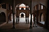
Chhatri are semi-open, elevated, dome-shaped pavilions used as an element in Indo-Islamic architecture and Indian architecture. They are most commonly square, octagonal, and round.

The Hawa Mahal is a palace in the city of Jaipur, Rajasthan, India. Built from red and pink sandstone, it is on the edge of the City Palace, Jaipur, and extends to the Zenana, or women's chambers.

Shekhawat is a clan of Rajputs found mainly in Shekhawati region of Rajasthan. Shekhawats are descendants of Maharao Shekha of Amarsar. The Shekhawat Rajputs trace their lineage to Shekha Rao, a prominent Rajput chieftain from the 15th century. Shekha Rao was a descendant of Rao Kalyan Singh, who belonged to the Kachwaha Rajput clan. Rao Shekha established his own principality in the Shekhawati region of Rajasthan, which includes parts of present-day Jhunjhunu, Sikar, and Churu districts. His leadership helped consolidate Rajput power in this region. Over time, the Shekhawat Rajputs expanded their territories and established several forts and palaces. The Shekhawat Rajputs established their dominance in the Shekhawati region in the 15th century, specifically starting around the time of Shekha Rao's rise to prominence in the early 1400s. They played a significant role in regional politics and were known for their martial prowess and resistance against Mughal expansion. Their rule continued until the mid-20th century when the princely states were integrated into the Indian Union. Thus, the Shekhawat Rajputs governed the Shekhawati region for approximately 500 years, from the early 15th century until the 1940s and 1950s, when princely states were absorbed into independent India. Shekhawat is a very common surname in the Indian defence forces.

Khetri Nagar is a town in the Neem Ka Thana district of Rajasthan in India. It is a part of the Shekhawati region. Khetri consists of two towns, "Khetri Town," founded by Raja Raja Bhopal Singh Ji, and "Khetri Nagar," which is about 10 km away from Khetri. Khetri Nagar, well known for its Copper Project, was built by and is under the control of Hindustan Copper Limited, a public sector undertaking under the Government of India. Khetri Nagar is also known as "Copper." There are many attached villages near Khetri Nagar, such as Manota Khurd; the people of this village were employed in mines.
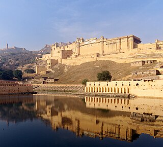
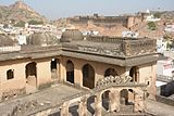
Amer Fort or Amber Fort is a fort located in Amer, Rajasthan, India. Amer is a town with an area of 4 square kilometres (1.5 sq mi) located 11 kilometres (6.8 mi) from Jaipur, the capital of Rajasthan. Located high on a hill, it is the principal tourist attraction in Jaipur. Amer Fort is known for its artistic style elements. With its large ramparts and series of gates and cobbled paths, the fort overlooks Maota Lake, which is the main source of water for the Amer Palace.
Loharu is a city, municipal committee and assembly constituency, near Bhiwani City in the Bhiwani district of the Indian state of Haryana. It is the administrative headquarters of one of the four administrative sub-divisions of the district and covers 119 villages. It is also a railway junction station.
Mandawa is a town, just 29 km from Jhunjhunu city in Jhunjhunu district of Rajasthan, India. It is part of Shekhawati region. Mandawa is located at 28.05°N 75.15°E. It has an average elevation of 316 metres (1036 ft). The nearest railway station is Jhunjhunu railway station.

Jhunjhunu district is a district of the Indian state of Rajasthan in northern India. The city of Jhunjhunu is the district headquarters. Jhunjhunu is an old and historical town having its own district headquarters. It is said that it was ruled over by Chouhan dynasty in the Vikram era 1045. The district is famous for the frescos on its grand Havelis. It is also famous for providing considerable representation to Indian defense forces. Jhunjhunu district was named in the memory of a Jat named "Jhunjha" or "Jujhar Singh Nehra". The district has a population of 2,139,658, an area of 5926 km2, and a population density of 361 persons per km. The district falls within Shekhawati region, and is bounded on the North-East and East by Haryana state, on the South-East, South & South-West by Sikar District & on the North-West and North by Churu District.

Junagarh Fort is a fort in the city of Bikaner, Rajasthan, India. The fort was originally called Chintamani and was renamed Junagarh or "Old Fort" in the early 20th century when the ruling family moved to Lalgarh Palace outside the fort limits. It is one of the few major forts in Rajasthan which is not built on a hilltop. The modern city of Bikaner has developed around the fort.

Jal Mahal is a palace in the middle of the Man Sagar Lake in Jaipur city, the capital of the state of Rajasthan, India. The palace was originally constructed around 1699; the building and the lake around it were later renovated and enlarged in the early 18th century by Maharaja Jai Singh II of Amber.
Maharao Shardul Singh ji Shekhawat (1681-1742) was the Shekhawat ruler of Jhunjhunu. During his reign, the Shekhawats are considered to have reached the height of their powers. After his death the estate was divided equally among his surviving five sons, whose descendants continued to rule over it until India achieved independence.
Tain is a village in the Jhunjhunu district, India. It is part of the Shekhawati region of Rajasthan.

Mandela is a town in the Shekhawati region and Jhunjhunu district of Rajasthan state in India.
Panchpana were the combined territories and thikanas ruled by the successors of Maharao Shardul Singh of Jhunjhunu, who belonged to the Bhojraj Ji Ka clan of Shekhawats. The Bhojraj Ji Ka Shekhawats ruled over two territories; Pentalisa and Panchpana. The Bhojraj Ji Ka clan of Shekhawats were the most prominent among the Shekhawat Rajputs. They built many magnificent forts in their thikanas. Panchpana thakurs ruled over highest number of thikanas in Shekhawati. Many thikanas had their own flags and emblems.

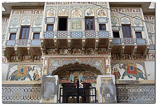
The region of Shekhawati in Rajasthan is remarkable for its wealth of mural paintings which adorn the walls of many buildings, including havelis.
Madhogarh is a village in Mahendragarh district, Haryana, India. It is located at the foot of Madhogarh Hill of Aravalli Mountain Range. Madhogarh Fort is on top of the hill.
Loharu Fort, built in 16th century, is a state protected archaeological monument in Loharu town in Haryana state of India. Fort is part of interstate Shekhawati region which lies on the either side of Haryana-Rajasthan border in the sandy bagar tract.