The Diablerets are a huge ice-covered mountain massif of the Alps, culminating at the Sommet des Diablerets (VS) at 3,216 metres (10,551 ft) above sea level and almost straddling the border between the Swiss cantons of Vaud (VD) and Valais (VS). The northeastern part of the massif stretches also into the canton of Bern (BE).
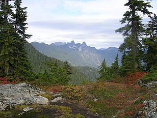
Cypress Provincial Park is a provincial park on the North Shore of Metro Vancouver Regional District, British Columbia. The park has two sections: a 21 km2 (8.1 sq mi) southern section which is accessible by road from West Vancouver, and a 9 km2 (3.5 sq mi) northern section which is only accessible by hiking trails. The two sections are linked by a narrow strip of park along the mountainous Howe Sound Crest Trail.

Humphreys Peak is the highest mountain and the second most prominent peak after Mount Graham in the U.S. state of Arizona. With an elevation of 12,633 feet (3,851 m), it is located within the Kachina Peaks Wilderness in the Coconino National Forest, about 11 miles (17.7 km) north of Flagstaff, Arizona. Humphreys Peak is the highest of a group of dormant volcanic peaks known as the San Francisco Peaks.

Alpental, named after the German word for alpine valley, is both a valley in eastern King County, Washington, United States, and part of a ski area in the valley. The valley is about 50 miles (80 km) east of Seattle, Washington and is north of Snoqualmie Pass, in the Washington Cascades. It is a popular outdoor recreation destination in summer and winter. The ski area is one of four areas that make up The Summit at Snoqualmie.

Khamar-Daban, is a mountain range in Southern Siberia, Russia.

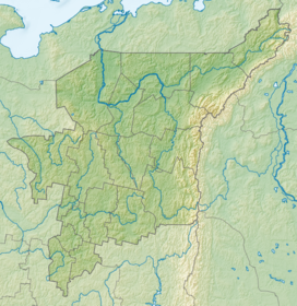
The Dyatlov Pass incident was an event in which nine Soviet ski hikers died in the northern Ural Mountains between February 1 and 2, 1959, under uncertain circumstances. The experienced trekking group from the Ural Polytechnical Institute, led by Igor Dyatlov, had established a camp on the eastern slopes of Kholat Syakhl in the Russian SFSR of the Soviet Union. Overnight, something caused them to cut their way out of their tent and flee the campsite while inadequately dressed for the heavy snowfall and subzero temperatures.

Mount Nikkō-Shirane is a stratovolcano in the Nikkō National Park in central Honshū, the main island of Japan. It stands at 2,578 m high. It is the highest mountain in north eastern Japan. Its peak is a Lava dome of andesite. Mt Nikkō-Shirane is listed in the 100 famous mountains in Japan proposed by Kyuya Fukada and also of one of the famous mountains of Tochigi and Gunma prefectures respectively.

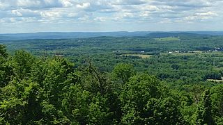
Sherburne Pass, is a mountain pass in the Green Mountains of Vermont, between 3,957-foot (1,206 m) Pico Peak to the south and 2,782-foot (848 m) Deer Leap Mountain to the north. The height of land of the pass is located in the town of Killington, while its western ascent begins in the town of Mendon.

Veleta or Pico del Veleta is the third highest peak of the Iberian Peninsula and the second highest of the Sierra Nevada. Its height is given variously as 3,394 metres (11,135 ft), 3,396 metres (11,142 ft) and 3,398 metres (11,148 ft).
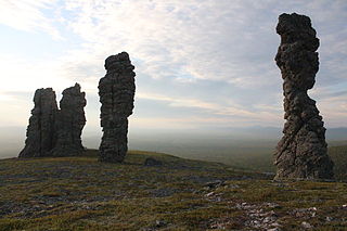
The Manpupuner rock formations are a set of 7 stone pillars located west of the Ural Mountains in the Troitsko-Pechorsky District of the Komi Republic. They are located on the territory of the Pechoro-Ilychski Reserve on the mountain Man-Pupu-nyor, between the Ilych and Pechora rivers. They are also known as the Seven Strong Men Rock Formations and the Poles of the Komi Republic. Deemed one of the Seven Wonders of Russia, the Manpupuner rock formations are a popular attraction in Russia, though relatively unspoiled by tourism.
Mount Peter is a 1,250-foot (380 m) mountain located in the New York – New Jersey Highlands, Bellvale Mountain, in the U.S. state of New York. The peak is located along the Appalachian Trail in the Town of Warwick, just south of New York State Route 17A, 38 miles (61 km) northwest of New York City, 2 miles (3.2 km) east of Bellvale, New York and north northwest of Greenwood Lake, New York.
Dyatlov is a Russian masculine surname; its feminine counterpart is Dyatlova. People with the names include:

Devil's Pass is a 2013 horror film directed by Renny Harlin, written by Vikram Weet, and starring Holly Goss, Matt Stokoe, Luke Albright, Ryan Hawley, and Gemma Atkinson as Americans who investigate the Dyatlov Pass incident. It is shot in the style of found footage.

Kholat is a survival horror game developed by IMGN.PRO, in which the player controls a protagonist who is tracing the steps of a group of nine Russian college students who went missing in February 1959 on Kholat Syakhl. The game is based on the Dyatlov Pass incident, a true event that involved ten Russian students, nine of which went missing on Kholat Syakhl and were found dead in the time span of four months. Холатчахль is a transliteration in Russian of Holatchahl, meaning "Dead Mountain" in Mansi.
In Khanty and Mansi folklore, the Menk is a forest spirit of these peoples' mythology. The Khanty and Mansi are Indigenous people living in the Khanty-Mansi Autonomous Okrug of Russia.
Priit Pius is an Estonian stage, television, and film actor whose career began in the 2010s.

The Chivruay Pass incident is the death of ten ski hikers in the Lovozero Massif in the Soviet Union between 27 and 28 January 1973. The trekking group, who were all from the Kuibyshev Aviation Institute, had been hiking the slopes of Lovozero Massif in an area of Chivruay Pass.

An Unknown Compelling Force is a 2021 American documentary film about the Dyatlov Pass incident, an event in which a group of nine Soviet alpine ski hikers, led by Igor Dyatlov, died in the northern Ural Mountains between February 1 and 2, 1959, under uncertain circumstances. The film is written and directed by Liam Le Guillou.

On 5 August 1993, six Kazakhstani hikers died in the Khamar-Daban mountain range under uncertain circumstances. The event has been likened to the Dyatlov Pass incident, earning it the name "Buryatia's Dyatlov Pass".