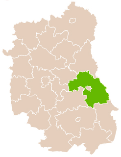
Gmina Żmudź is a rural gmina in Chełm County, Lublin Voivodeship, in eastern Poland. Its seat is the village of Żmudź, which lies approximately 20 kilometres (12 mi) south-east of Chełm and 81 km (50 mi) east of the regional capital Lublin.

Białopole is a village in Chełm County, Lublin Voivodeship, in eastern Poland. It is the seat of the gmina called Gmina Białopole. It lies approximately 26 kilometres (16 mi) south-east of Chełm and 87 km (54 mi) east of the regional capital Lublin.
Busieniec is a village in the administrative district of Gmina Białopole, within Chełm County, Lublin Voivodeship, in eastern Poland. It lies approximately 4 kilometres (2 mi) south of Białopole, 28 km (17 mi) south-east of Chełm, and 87 km (54 mi) east of the regional capital Lublin.
Buśno is a village in the administrative district of Gmina Białopole, within Chełm County, Lublin Voivodeship, in eastern Poland. It lies approximately 28 kilometres (17 mi) south-east of Chełm and 89 km (55 mi) east of the regional capital Lublin.
Grobelki is a village in the administrative district of Gmina Białopole, within Chełm County, Lublin Voivodeship, in eastern Poland. It lies approximately 4 kilometres (2 mi) north-east of Białopole, 27 km (17 mi) south-east of Chełm, and 90 km (56 mi) east of the regional capital Lublin.
Kurmanów is a village in the administrative district of Gmina Białopole, within Chełm County, Lublin Voivodeship, in eastern Poland. It lies approximately 4 kilometres (2 mi) south of Białopole, 29 km (18 mi) south-east of Chełm, and 88 km (55 mi) east of the regional capital Lublin.
Raciborowice is a village in the administrative district of Gmina Białopole, within Chełm County, Lublin Voivodeship, in eastern Poland. It lies approximately 5 kilometres (3 mi) south-east of Białopole, 30 km (19 mi) south-east of Chełm, and 90 km (56 mi) east of the regional capital Lublin.
Strzelce is a village in the administrative district of Gmina Białopole, within Chełm County, Lublin Voivodeship, in eastern Poland. It lies approximately 5 kilometres (3 mi) east of Białopole, 31 km (19 mi) south-east of Chełm, and 92 km (57 mi) east of the regional capital Lublin.
Zabudnowo is a village in the administrative district of Gmina Białopole, within Chełm County, Lublin Voivodeship, in eastern Poland. It lies approximately 26 kilometres (16 mi) south-east of Chełm and 89 km (55 mi) east of the regional capital Lublin.
Józefów is a village in the administrative district of Gmina Dubienka, within Chełm County, Lublin Voivodeship, in eastern Poland, close to the border with Ukraine. It lies approximately 8 kilometres (5 mi) south of Dubienka, 34 km (21 mi) south-east of Chełm, and 97 km (60 mi) east of the regional capital Lublin.
Radziejów is a village in the administrative district of Gmina Dubienka, within Chełm County, Lublin Voivodeship, in eastern Poland, close to the border with Ukraine. It lies approximately 9 kilometres (6 mi) west of Dubienka, 24 km (15 mi) south-east of Chełm, and 87 km (54 mi) east of the regional capital Lublin.
Zagórnik is a village in the administrative district of Gmina Dubienka, within Chełm County, Lublin Voivodeship, in eastern Poland, close to the border with Ukraine. It lies approximately 9 kilometres (6 mi) south-east of Dubienka, 37 km (23 mi) south-east of Chełm, and 100 km (62 mi) east of the regional capital Lublin.
Alojzów is a village in the administrative district of Gmina Leśniowice, within Chełm County, Lublin Voivodeship, in eastern Poland. It lies approximately 5 kilometres (3 mi) east of Leśniowice, 20 km (12 mi) south of Chełm, and 75 km (47 mi) south-east of the regional capital Lublin.
Janówka is a village in the administrative district of Gmina Leśniowice, within Chełm County, Lublin Voivodeship, in eastern Poland. It lies approximately 19 kilometres (12 mi) south of Chełm and 71 km (44 mi) south-east of the regional capital Lublin.
Plisków is a village in the administrative district of Gmina Leśniowice, within Chełm County, Lublin Voivodeship, in eastern Poland. It lies approximately 3 kilometres (2 mi) west of Leśniowice, 19 km (12 mi) south of Chełm, and 69 km (43 mi) south-east of the regional capital Lublin.
Politówka is a village in the administrative district of Gmina Leśniowice, within Chełm County, Lublin Voivodeship, in eastern Poland. It lies approximately 3 kilometres (2 mi) east of Leśniowice, 19 km (12 mi) south of Chełm, and 73 km (45 mi) south-east of the regional capital Lublin.
Bielin is a village in the administrative district of Gmina Żmudź, within Chełm County, Lublin Voivodeship, in eastern Poland. It lies approximately 8 kilometres (5 mi) north-east of Żmudź, 23 km (14 mi) south-east of Chełm, and 87 km (54 mi) east of the regional capital Lublin.

Kornelówka is a village in the administrative district of Gmina Sitno, within Zamość County, Lublin Voivodeship, in eastern Poland. It lies approximately 4 kilometres (2 mi) north-west of Sitno, 8 km (5 mi) north-east of Zamość, and 76 km (47 mi) south-east of the regional capital Lublin.
Leżne is a village in the administrative district of Gmina Jasieniec, within Grójec County, Masovian Voivodeship, in east-central Poland. It lies approximately 9 kilometres (6 mi) south-east of Jasieniec, 14 km (9 mi) south-east of Grójec, and 50 km (31 mi) south of Warsaw.