
The Kickapoo people are an Algonquian-speaking Native American tribe and Indigenous people in Mexico, originating in the region south of the Great Lakes. Today, three federally recognized Kickapoo tribes are in the United States: the Kickapoo Tribe in Kansas, the Kickapoo Tribe of Oklahoma, and the Kickapoo Traditional Tribe of Texas. The Oklahoma and Texas bands are politically associated with each other. The Kickapoo in Kansas came from a relocation from southern Missouri in 1832 as a land exchange from their reserve there. Around 3,000 people are enrolled tribal members.
Lake Kickapoo is a reservoir located on the North Fork Little Wichita River in the Red River Basin of Archer County, Texas. It is neighbored by Archer City, Texas and Wichita Falls, Texas which reside within the Central Great Plains ecoregion.

Tom Green County is a county located on the Edwards Plateau in the U.S. state of Texas. As of the 2020 census, its population was 120,003. Its county seat is San Angelo. The county was created in 1874 and organized the following year. It is named for Thomas Green, who was a Confederate soldier and lawyer. Tom Green County is included in the San Angelo metropolitan statistical area; the county is home to Goodfellow Air Force Base, as well as Angelo State University, part of the Texas Tech University System.

Sterling County is a county located on the Edwards Plateau in the U.S. state of Texas. As of the 2020 census, its population was 1,372, making it the ninth-least populous county in Texas. Its county seat is Sterling City. The county is named for W. S. Sterling, an early settler in the area. Sterling County was one of 30 prohibition, or entirely dry, counties in the state of Texas, but is now a moist county.

The Colorado River is an approximately 862-mile-long (1,387 km) river in the U.S. state of Texas. It is the 11th longest river in the United States and the longest river with both its source and its mouth within Texas.
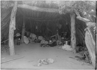
The Kickapoo Tribe of Oklahoma is one of three federally recognized Kickapoo tribes in the United States. There are also Kickapoo tribes in Kansas, Texas, and Mexico. The Kickapoo are a Woodland tribe, who speak an Algonquian language. They are affiliated with the Kickapoo Traditional Tribe of Texas, the Kickapoo Tribe in Kansas, and the Mexican Kickapoo.
Ben Ficklin (Benficklin), Texas is a ghost town and the former county seat of Tom Green County from 1875 to 1882. It was located 5 miles (8 km) south of Fort Concho on the east bank of the South Concho River.
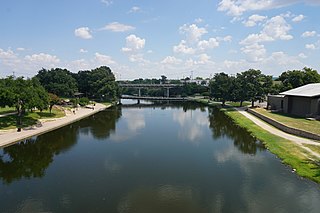
The Concho River is a river in the U.S. state of Texas. Concho is Spanish for "shell"; the river was so named due to its abundance of freshwater mussels, such as the Tampico pearly mussel.
Salt Creek is a major tributary to the Sangamon River, which it joins at the boundary between Mason and Menard County, Illinois. There are at least two other Salt Creeks in Illinois, Salt Creek, and in Effingham County, Illinois.
Ouiatenon was a dwelling place of members of the Wea tribe of Native Americans. The name Ouiatenon, also variously given as Ouiatanon, Oujatanon, Ouiatano or other similar forms, is a French rendering of a term from the Wea dialect of the Miami-Illinois language which means "place of the people of the whirlpool", an ethnonym for the Wea. Ouiatenon can be said to refer generally to any settlement of Wea or to their tribal lands as a whole, though the name is most frequently used to refer to a group of extinct settlements situated together along the Wabash River in what is now western Tippecanoe County, Indiana.

The North Concho River is a river in west-central Texas and one of three tributaries of the Concho River. The river is 88 miles (142 km) long. The other two tributaries are the Middle Concho and South Concho Rivers. The Concho River flows into the Colorado River.
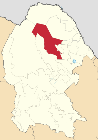
Múzquiz is one of the 38 municipalities of Coahuila, in north-eastern Mexico. The municipal seat lies at Santa Rosa de Múzquiz. The municipality covers an area of 8,128.9 square kilometres (3,138.6 sq mi).
The Battle of Dove Creek was a small engagement during the American Civil War that took place January 8, 1865, along Dove Creek in what is now southwest Tom Green County, Texas. Texan soldiers under Confederate captains Henry Fossett and S.S. Totten, misunderstanding which tribe occupied a discovered camp, attacked a tribe of peaceful Kickapoo Indians and were badly beaten by an organized defense.
Brady Creek is a river in San Saba, McCulloch, and Concho counties in western Texas, United States, that is a tributry of the San Saba River. Its mouth is about 17 miles (27 km) south-southwest of San Saba. Brady Creek Reservoir impounds its water in western Brady.
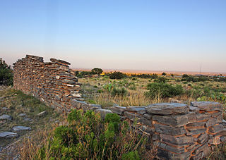
In Texas, the Butterfield Overland Mail service created by Congress on March 3, 1857, was operated until March 30, 1861.
The Battle of Village Creek, also known as the Village Creek Massacre, occurred on May 24, 1841, on the embankments of Village Creek in what was then the Republic of Texas. The site of the massacre is now located in Tarrant County, Texas, named for Edward H. Tarrant, who commanded the Texan forces in the massacre. Tarrant rallied a volunteer militia of 69 men, including Captain John B. Denton, who would be the Texans’ only fatality and who would also go on to have a North Texas county bear his name. The Texans used information from a Native American man they had captured to locate the villages, after which they launched a surprise attack which evolved into a running gunfight between the Republic of Texas militia and the Cherokee, Muscogee/Creek, Seminole, Waco, Caddo, Kickapoo, Tonkawa, Wichita, Shawnee, and Anadarko villagers who inhabited Village Creek. Texans used the occurrence of increased Native American raids on Anglo settlements in the Red River counties as justification for the massacre, which was a part of the larger pattern in the Republic of Texas, under the leadership of President Mirabeau B. Lamar, to wage an “exterminating war” on Native peoples, calling for “their total extinction or total expulsion.”
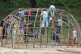
The Mexican Kickapoo are a binational Indigenous people, some of whom live both in Mexico and in the United States. In Mexico, they were granted land at Hacienda del Nacimiento near the town of Múzquiz in the state of Coahuila in 1850. A few small groups of Kickapoo also live in the states of Sonora and Durango. The Mexican Kickapoo often work as migrants in Texas and move throughout the Midwest and the Western United States, returning in winter to Mexico. They are affiliated with the federally recognized tribes of the Kickapoo Traditional Tribe of Texas, Kickapoo Tribe of Oklahoma, and Kickapoo Tribe in Kansas.
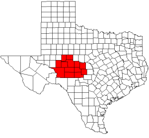
The Concho Valley is a region in West Texas. The region takes its name from the Concho River, named due to its abundance of freshwater mussels in the river.

Kickapoo Creek originates in McLean County, near Bentown, Illinois and the Benjaminville Historic Site. The creek eventually joins Salt Creek in Logan County, Illinois which also makes it a tributary of the Sangamon, Illinois, and Mississippi rivers.


