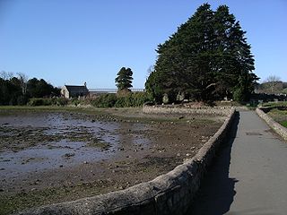
Church Island is a small island in the Menai Strait on the shores of Anglesey to which it is attached by a short causeway that is reachable only on foot off the Belgian Promenade. The whole 2.7 acres (11,000 m2) of the island is taken up with St Tysilio's church, constructed in the 15th century, and the churchyard. The 20th-century bard Cynan is buried in the churchyard. The Anglesey Coastal Path passes the head of the causeway.
Dębiny is a village in the administrative district of Gmina Łubianka, within Toruń County, Kuyavian-Pomeranian Voivodeship, in north-central Poland. It lies approximately 18 km (11 mi) north-west of Toruń and 34 km (21 mi) east of Bydgoszcz.

Warszewice is a village in the administrative district of Gmina Łubianka, within Toruń County, Kuyavian-Pomeranian Voivodeship, in north-central Poland. It lies approximately 5 kilometres (3 mi) north-east of Łubianka and 17 km (11 mi) north of Toruń.
Pałatki is a village in the administrative district of Gmina Gródek, within Białystok County, Podlaskie Voivodeship, in north-eastern Poland, close to the border with Belarus. It lies approximately 17 kilometres (11 mi) north-west of Gródek and 20 km (12 mi) east of the regional capital Białystok.
Pawłowice is a village in the administrative district of Gmina Krzyżanów, within Kutno County, Łódź Voivodeship, in central parts of Poland. It lies approximately 3 kilometres (2 mi) south-east of Krzyżanów, 11 km (7 mi) south-east of Kutno, and 44 km (27 mi) north of the regional capital Łódź.
Sopel is a village in the administrative district of Gmina Wieruszów, within Wieruszów County, Łódź Voivodeship, in central Poland. It lies approximately 4 kilometres (2 mi) north-east of Wieruszów and 103 km (64 mi) south-west of the regional capital Łódź.
Rudniki is a village in the administrative district of Gmina Łopuszno, within Kielce County, Świętokrzyskie Voivodeship, in south-central Poland. It lies approximately 5 kilometres (3 mi) north-west of Łopuszno and 31 km (19 mi) west of the regional capital Kielce.
Płowce is a village in the administrative district of Gmina Sanok, within Sanok County, Subcarpathian Voivodeship, in south-eastern Poland. It lies approximately 4 kilometres (2 mi) west of Sanok and 56 km (35 mi) south of the regional capital Rzeszów.
Kamionka is a village in the administrative district of Gmina Piaseczno, within Piaseczno County, Masovian Voivodeship, in east-central Poland.
Wolanów is a village in Radom County, Masovian Voivodeship, in east-central Poland. It is the seat of the gmina called Gmina Wolanów. It lies approximately 14 kilometres (9 mi) west of Radom and 93 km (58 mi) south of Warsaw.
Pieńki is a village in the administrative district of Gmina Kotuń, within Siedlce County, Masovian Voivodeship, in east-central Poland.
Wierzbnik is a settlement in the administrative district of Gmina Czarne, within Człuchów County, Pomeranian Voivodeship, in northern Poland. It lies approximately 3 kilometres (2 mi) south-east of Czarne, 26 km (16 mi) west of Człuchów, and 133 km (83 mi) south-west of the regional capital Gdańsk.
Wierzysko is a settlement in the administrative district of Gmina Kościerzyna, within Kościerzyna County, Pomeranian Voivodeship, in northern Poland. It lies approximately 3 kilometres (2 mi) south of Kościerzyna and 52 km (32 mi) south-west of the regional capital Gdańsk.
Chrztowo is a village with a population of 80 in northern Poland. The village is within the administrative district of Gmina Liniewo, which is within Kościerzyna County, in the provincial region of the Pomeranian Voivodeship. It lies approximately 5 km south-west of Liniewo, 14 km south-east of Kościerzyna, and 46 hm southwest of the regional capital, Gdańsk.
Ruda is a village in the administrative district of Gmina Miłki, within Giżycko County, Warmian-Masurian Voivodeship, in northern Poland. It lies approximately 6 kilometres (4 mi) north of Miłki, 9 km (6 mi) south-east of Giżycko, and 91 km (57 mi) east of the regional capital Olsztyn.
Przylaski is a former settlement in the administrative district of Gmina Kołobrzeg, within Kołobrzeg County, West Pomeranian Voivodeship, in north-western Poland.
Mokre is a village in the administrative district of Gmina Sianów, within Koszalin County, West Pomeranian Voivodeship, in north-western Poland. It lies approximately 10 kilometres (6 mi) south-east of Sianów, 15 km (9 mi) east of Koszalin, and 147 km (91 mi) north-east of the regional capital Szczecin.
Palasi is a village in Kehtna Parish, Rapla County in northern-central Estonia.

Borovac is a village in the municipality of Sokolac, Bosnia and Herzegovina.
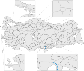
Otoyol 53, abbreviated as O-53, also known as Ceyhan-İskenderun Otoyolu, is a toll motorway in Mediterranean Region, Turkey, connecting the Adana-Şanlıurfa Motorway O-52 with İskenderun. The motorway is part of international routes as European route E91 and Asian Highway 84.


