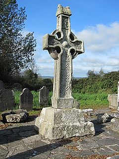
A high cross or standing cross is a free-standing Christian cross made of stone and often richly decorated. There was a unique Early Medieval tradition in Ireland and Britain of raising large sculpted stone crosses, usually outdoors. These probably developed from earlier traditions using wood, perhaps with metalwork attachments, and earlier pagan Celtic memorial stones; the Pictish stones of Scotland may also have influenced the form. The earliest surviving examples seem to come from the territory of the Anglo-Saxon kingdom of Northumbria, which had been converted to Christianity by Irish missionaries; it remains unclear whether the form first developed in Ireland or Britain.

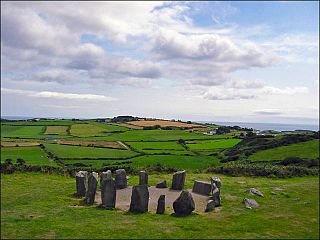
A stone circle is a ring of standing stones. Most are found in Northwestern Europe – especially in Britain, Ireland, and Brittany – and typically date from the Late Neolithic and Early Bronze Age, with most being built from 3000 BC. The best known examples include those at the henge monument at Avebury, the Rollright Stones, and elements within the ring of standing stones at Stonehenge. Scattered examples exist from other parts of Europe. Later, during the Iron Age, stone circles were built in southern Scandinavia.

West Cork is a tourist region and municipal district in County Cork, Ireland. As a municipal district, West Cork falls within the administrative area of Cork County Council, and includes the towns of Bantry, Castletownbere, Clonakilty, Dunmanway, Schull and Skibbereen, and the villages of Baltimore, Ballydehob, Courtmacsherry, Drimoleague, Durrus, Glengarriff, Leap, Rosscarbery, Timoleague and Union Hall.

Bantry is a town in the civil parish of Kilmocomoge in the barony of Bantry on the southwest coast of County Cork, Ireland. It lies in West Cork at the head of Bantry Bay, a deep-water gulf extending for 30 km (19 mi) to the west. The Beara Peninsula is to the northwest, with Sheep's Head peninsula to the southwest.

Sheep's Head, also known as Muntervary, is the headland at the end of the Sheep's Head peninsula situated between Bantry Bay and Dunmanus Bay in County Cork, Ireland.

Celtic art is associated with the peoples known as Celts; those who spoke the Celtic languages in Europe from pre-history through to the modern period, as well as the art of ancient peoples whose language is uncertain, but have cultural and stylistic similarities with speakers of Celtic languages.

Boa Island is an island near the north shore of Lower Lough Erne in County Fermanagh, Northern Ireland. It is 25 km (16 mi) from Enniskillen town.

Durrus is a village and civil parish in West Cork in Ireland. It is situated ten kilometres (6 mi) from Bantry in County Cork, at the head of the Sheep's Head and the Mizen Head peninsulas.

Drombeg stone circle, is a small axial stone circle located 2.4 km (1.5 mi) east of Glandore, County Cork, Ireland.

The Eassie Stone is a Class II Pictish stone of about the mid 8th century AD in the village of Eassie, Angus, Scotland. The stone was found in Eassie burn in the late 18th century and now resides in a purpose-built perspex building in the ruined Eassie church.

Killamery Cross is a 9th-century high cross and National Monument in Killamery, County Kilkenny, Ireland. It is located in the north of Killamery graveyard.
Lankill Standing Stone is a standing stone and National Monument located in County Mayo, Ireland.
Kildun Standing Stones are standing stones, forming a National Monument, located in County Mayo, Ireland.
Ballintaggart Ogham Stones is a collection of ogham stones forming a National Monument located in County Kerry, Ireland.
The Coolcoulaghta Standing Stones are a pair of standing stones forming a stone row and National Monument located in County Cork, Ireland.
Breeny More Stone Circle is an axial stone circle and National Monument located in County Cork, Ireland.

Labbamolaga Church is a medieval church and National Monument located in County Cork, Ireland.

Kealkill stone circle is a bronze age axial five-stone circle located just outside the village of Kealkill, County Cork in southwest Ireland. When it was excavated in 1938 it was thought the crucial axial stone indicated an alignment to the north, contrary to the general alignment of such stone circles to the southwest. However, later archaeologists have thought it is the comparatively insignificant stone to the southwest that is the axial stone. There are two associated standing stones nearby, one of which had fallen and was re-erected in 1938.


