Jauja Province is a Peruvian province. It is one of the nine provinces of the Junín Region. To the north it borders with the Yauli, Tarma and Chanchamayo Provinces. To the east with the Satipo Province, to the south with the Concepción Province and to the west with the Lima Region. The capital of the Jauja Province is the city of Jauja. The city was founded by Francisco Pizarro as the first capital of Peru.

Canchayllo District is one of thirty-four districts of the Jauja Province in Peru. Its seat is Canchayllo.
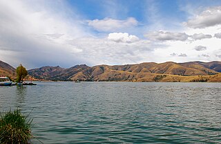
Lake Llacsacocha is a lake in Peru located in the Junín Region, Jauja Province, Canchayllo District. It lies northeast of a lake with the same name, southwest of Chalhuacocha and west of Mancacocha.
Mancacocha is a lake in Peru located in the Junín Region, Jauja Province, Canchayllo District. It lies east of the lake Llacsacocha, southwest of the lake Chalhuacocha and south of the mountain Chalhuacocha (possibly from Quechua Challwaqucha). Mancacocha is connected with the lake Chaquipaque southeast of it, situated at the foot of the mountain Chaquipaque.

Puka Rumi is a 5,000-metre-high (16,404 ft) mountain in the northern part of the Chunta mountain range in the Andes of Peru. It is situated in the Huancavelica Region, Huancavelica Province, Acobambilla District, and in the Junín Region, Huancayo Province, Chongos Alto District. Puka Rumi lies southeast of Ñawinqucha.
Quimarumi, also known as Minas, is a 5,459-metre-high (17,910 ft) mountain in the Cordillera Blanca in the Andes of Peru. It is located in the Ancash Region, Huaraz Province, Huaraz District. Quimarumi lies on a ridge between the Quilcayhuanca valley and the Shallap valley, northwest of Carhuascancha and northeast of Qullapaqu.
Puka Rumi is a 5,028-metre-high (16,496 ft) mountain in the Andes of Peru. It is located in the Junín Region, Yauli Province, Marcapomacocha District. It lies northwest of Chunta and Kashpi.
Ch'uychu is a mountain in the Cordillera Central in the Andes of Peru which reaches an altitude of approximately 4,600 metres (15,092 ft). It is located in the Junín Region, Jauja Province, Canchayllo District, and in the Yauli Province, Suitucancha District, southeast of Suitucancha.
Huarmicochas Lakes are a group of lakes in Peru located in the Junín Region, Jauja Province, Canchayllo District. They're located east of the Pariacaca mountain range.
Rumi Pukyu is a mountain in the Andes of Peru which reaches a height of approximately 4,200 m (13,800 ft). It lies in the Junín Region, Tarma Province, on the border of the districts of Acobamba and Huasahuasi. Rumi Pukyu lies on the left bank of the Pallqamayu, north of the village of Acobamba.
Marayrazo is a mountain in the Andes of Peru which reaches a height of approximately 4,800 metres (15,748 ft). It is located in the Junín Region, Jauja Province, Apata District.
Utkhulasu is a mountain in the Andes of Peru which reaches a height of approximately 5,000 metres (16,404 ft). It is located in the Junín Region, in the Concepción Province, Cochas District, and in the Jauja Province, Apata District.
Antikuna is a mountain in the Andes of Peru which reaches a height of approximately 4,800 metres (15,748 ft). It is located in the Junín Region, Jauja Province, Apata District. Antikuna lies south of Utkhulasu and T'uruqucha.
Mata Mach'ay is a mountain in the Andes of Peru which reaches a height of approximately 4,400 metres (14,436 ft). It is located in the Junín Region, Jauja Province, Pomacancha District.
Muntirayuq is a mountain in the Cordillera Central in the Andes of Peru which reaches a height of approximately 4,200 metres (13,780 ft). It is located in the Junín Region, Jauja Province, Pomacancha District.
Yuraq Kancha is a mountain in the Cordillera Central in the Andes of Peru which reaches a height of approximately 4,600 metres (15,092 ft). It is located in the Junín Region, Jauja Province, Canchayllo District.


