Canchayllo | |
---|---|
District | |
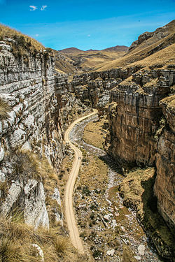
A canyon in the Nor Yauyos-Cochas Landscape Reserve in Canchayllo District | |
Country | |
Region | Junín |
Province | Jauja |
Founded | October 15, 1954 |
Capital | Canchayllo |
Government | |
• Mayor | Raul Ricardo Zavala Rojas |
Area | |
• Total | 974.69 km2 (376.33 sq mi) |
Elevation | 3,609 m (11,841 ft) |
Population (2005 census) | |
• Total | 2,304 |
• Density | 2.4/km2 (6.1/sq mi) |
Time zone | PET (UTC-5) |
UBIGEO | 120405 |
Canchayllo District is one of thirty-four districts of the Jauja Province in Peru. [1] Its seat is Canchayllo.
The districts of Peru are the third-level country subdivisions of Peru. They are subdivisions of the provinces, which in turn are subdivisions of the larger regions or departments. There are 1,838 districts in total.
Jauja Province is a Peruvian province. It is one of the nine provinces of the Junín Region. To the north it borders with the Yauli, Tarma and Chanchamayo Provinces. To the east with the Satipo Province, to the south with the Concepción Province and to the west with the Lima Region. The capital of the Jauja Province is the city of Jauja. The city was founded by Francisco Pizarro as the first capital of Peru.
Peru, officially the Republic of Peru, is a country in western South America. It is bordered in the north by Ecuador and Colombia, in the east by Brazil, in the southeast by Bolivia, in the south by Chile, and in the west by the Pacific Ocean. Peru is a megadiverse country with habitats ranging from the arid plains of the Pacific coastal region in the west to the peaks of the Andes mountains vertically extending from the north to the southeast of the country to the tropical Amazon Basin rainforest in the east with the Amazon river.
The district lies in the Nor Yauyos-Cochas Landscape Reserve. The Paryaqaqa mountain range traverses the district. The highest mountain of the district is Paryaqaqa (Tulluqutu) at 5,750 metres (18,865 ft). Other mountains are listed below: [2]
The Nor Yauyos-Cochas Landscape Reserve is a protected area in Peru located in the Lima Region, Yauyos Province and in the Junín Region, Jauja Province. It lies with the Peruvian Yungas and Central Andean wet puna ecoregions.
Ch'uychu is a mountain in the Cordillera Central in the Andes of Peru which reaches an altitude of approximately 4,600 metres (15,092 ft). It is located in the Junín Region, Jauja Province, Canchayllo District, and in the Yauli Province, Suitucancha District, southeast of Suitucancha.
Kima Rumi is a mountain in the Cordillera Central in the Andes of Peru which reaches a height of approximately 4,600 metres (15,092 ft). It is located in the Junín Region, Jauja Province, Canchayllo District, and in the Lima Region, Yauyos Province, Huancaya District.
Qiwllaqucha is a mountain in the Cordillera Central in the Andes of Peru which reaches a height of approximately 4,400 metres (14,436 ft). It is located in the Junín Region, Jauja Province, Canchayllo District.
Some of the largest lakes of the province are Antaqucha, Asulqucha, Challwaqucha, Llaksaqucha, Mankhaqucha, Qarwaqucha, Ñawinqucha, Warmiqucha, Wich'iqucha and Yuraqqucha. [2]
Antaqucha is a lake in Peru located in the Junín Region, Jauja Province, Canchayllo District. It belongs to the watershed of the Mantaro River.
Qarwaqucha is a lake in Peru located in the Junín Region, Jauja Province, Canchayllo District. It lies southeast of the peaks of Tunshu and Tukumach'ay and west of a lake named Wayllakancha (Huayllacancha). It belongs to the watershed of the Mantaro River.
Ñawinqucha is a lake in Peru located in the Junín Region, Jauja Province, Canchayllo District, northeast of the Paryaqaqa mountain range. The lake belongs to the watershed of the Mantaro River.
Huarochirí Province or Waruchiri is located in the Lima Region of Peru. Its capital is Matucana. The western section is part of the Lima Metropolitan Area.
The Tarma Province is a Peruvian province, making up one of the nine provinces that conform the Junín Region. To the north it borders with the Junín Province, the east with the Chanchamayo Province, the south with the Jauja Province and the west with the Yauli Province.
The Yauli Province is one of the nine provinces in Peru that form the Junín Region. It is bordered to the north by the Pasco Region and the Junín Province, to the east by the Tarma Province, to the south by the Jauja Province and to the west by the Lima Region. The population of the province was estimated at 66,093 inhabitants in 2002. The capital of the Yauli Province is La Oroya.
The Yungay Province is one of twenty provinces of the Ancash Region in Peru.
The Dos de Mayo Province is one of eleven provinces of the Huánuco Region in Peru. The capital of this province is the city of La Unión.
Haquira District is one of the six districts of the Cotabambas Province in Peru.
Coronel Castañeda District is one of eight districts of the Parinacochas Province in Peru.
Junín District is one of four districts of the Junín Province in Peru.
Ulcumayo is one of four districts of the Junín Province in Peru.
Ricran District is one of thirty-four districts of the Jauja Province in Peru.
La Oroya District is one of ten districts of the Yauli Province in Peru. It is a region that is rich in zinc, lead and copper.
Paccha is one of ten districts of the Yauli Province in Peru.
Huamantanga is one of seven districts of the Canta Province in Peru.
Vilca District is one of nineteen districts of the Huancavelica Province in Peru.
Ragash District is one of ten districts of the Sihuas Province in Peru.
Cusca District is one of seven districts of the province Corongo in Peru.
Suyruqucha is a mountain in the Paryaqaqa or Waruchiri mountain range in the Andes of Peru, about 5,500 metres (18,045 ft) high. It is located in the Junín Region, Jauja Province, Canchayllo District, in the Yauli Province, Suitucancha District, and in the Lima Region, Huarochiri Province, Quinti District. It lies on the western border of the Nor Yauyos-Cochas Landscape Reserve. It is situated northwest of Qullqip'ukru. Wararayuq lies west of it.
Yuraqqucha is a lake in Peru. It is situated in the Junín Region, Jauja Province, Canchayllo District, east of Wich'iqucha. It belongs to the watershed of the Mantaro River.
This Junín Region geography article is a stub. You can help Wikipedia by expanding it. |
Coordinates: 11°48′11″S75°43′02″W / 11.8030°S 75.7171°W
A geographic coordinate system is a coordinate system that enables every location on Earth to be specified by a set of numbers, letters or symbols. The coordinates are often chosen such that one of the numbers represents a vertical position and two or three of the numbers represent a horizontal position; alternatively, a geographic position may be expressed in a combined three-dimensional Cartesian vector. A common choice of coordinates is latitude, longitude and elevation. To specify a location on a plane requires a map projection.