Tunan Marca District

Last updated
Tunan Marca
Tunan Marka
District

Tunanmarca Archaeological site - wall.jpg

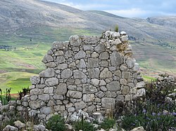
Ruins at the archaeological site of Tunanmarka
Country Flag of Peru.svg  Peru
Region Junín
Province Jauja
Founded September 15, 1944
Capital Concho
Government
   Mayor Braulio Abilio Tabraj Flores
Area
  Total 30.07 km2 (11.61 sq mi)
Elevation 3,470 m (11,380 ft)
Population (2005 census)
  Total 1,357
  Density 45/km2 (120/sq mi)
Time zone PET (UTC-5)
UBIGEO 120432

Tunan Marca District is one of thirty-four districts of the province Jauja in Peru. [1]

Districts of Peru third level administrative subdivision of Peru

The districts of Peru are the third-level country subdivisions of Peru. They are subdivisions of the provinces, which in turn are subdivisions of the larger regions or departments. There are 1,838 districts in total.

Jauja Province Province in Junín, Peru

Jauja Province is a Peruvian province. It is one of the nine provinces of the Junín Region. To the north it borders with the Yauli, Tarma and Chanchamayo Provinces. To the east with the Satipo Province, to the south with the Concepción Province and to the west with the Lima Region. The capital of the Jauja Province is the city of Jauja. The city was founded by Francisco Pizarro as the first capital of Peru.

Peru republic in South America

Peru, officially the Republic of Peru, is a country in western South America. It is bordered in the north by Ecuador and Colombia, in the east by Brazil, in the southeast by Bolivia, in the south by Chile, and in the west by the Pacific Ocean. Peru is a megadiverse country with habitats ranging from the arid plains of the Pacific coastal region in the west to the peaks of the Andes mountains vertically extending from the north to the southeast of the country to the tropical Amazon Basin rainforest in the east with the Amazon river.

See also

Related Research Articles

Arroyo de la Encomienda Place in Castile and León, Spain

Arroyo de la Encomienda is a municipality located in the province of Valladolid, Castile and León, Spain. According to the 2015 census (INE), the municipality has a population of 18491 inhabitants.

Santa Cruz District is one of fifteen districts of the province Cutervo in Peru.

San Ramón District, Chanchamayo District in Junín, Peru

San Ramón District is one of six districts of the province Chanchamayo in Peru.

Ingenio District is one of twenty-eight districts of the province Huancayo in Peru.

San Jerónimo de Tunán District is one of twenty-eight districts of the province Huancayo in Peru.

Acolla District is one of thirty-four districts of the province Jauja in Peru.

El Mantaro District is one of thirty-four districts of the province Jauja in Peru.

Huamalí District is one of thirty-four districts of the province Jauja in Peru.

Huaripampa District District in Junín, Peru

Huaripampa District is one of thirty-four districts of the province Jauja in Peru.

Jauja District District in Junín, Peru

Jauja District is one of thirty-four districts of the province Jauja in Peru.

Julcán District is one of thirty-four districts of the province Jauja in Peru.

Leonor Ordóñez District is one of thirty-four districts of the province Jauja in Peru.

Muqui District is one of thirty-four districts of the province Jauja in Peru.

Muquiyauyo District is one of thirty-four districts of the province Jauja in Peru.

Paca District is one of thirty-four districts of the province Jauja in Peru.

Paccha District is one of thirty-four districts of the province Jauja in Peru.

San Pedro de Chunan District is one of thirty-four districts of the province Jauja in Peru.

Sausa District is one of thirty-four districts of the province Jauja in Peru.

Tupe District is one of thirty-three districts of the province of Yauyos in Peru. It is home to the Jaqaru ethnolinguistic minority.

Soplin District is one of eleven districts of the province Requena in Peru.

References

Coordinates: 11°42′58″S75°37′31″W / 11.7162°S 75.6253°W / -11.7162; -75.6253

Geographic coordinate system Coordinate system

A geographic coordinate system is a coordinate system that enables every location on Earth to be specified by a set of numbers, letters or symbols. The coordinates are often chosen such that one of the numbers represents a vertical position and two or three of the numbers represent a horizontal position; alternatively, a geographic position may be expressed in a combined three-dimensional Cartesian vector. A common choice of coordinates is latitude, longitude and elevation. To specify a location on a plane requires a map projection.