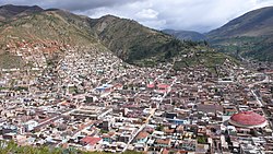
Tarma District

Last updated
Tarma
Tarmaperu1.JPG
Tarma
Tarma District
Country Flag of Peru.svg  Peru
Region Junín
Province Tarma
Capital Tarma
Government
 •  Mayor Fathy Jiménez
Area
 • Total
459.95 km2 (177.59 sq mi)
Elevation
3,053 m (10,016 ft)
Population
 (2017)
 • Total
47,775
 • Density100/km2 (270/sq mi)
Time zone UTC-5 (PET)
UBIGEO 120701
Website munitarma.gob.pe

Tarma District is one of nine districts of the province Tarma in Peru. [1]

Contents

The archaeological site Tarmatampu is situated in the district.

Geography

Some of the highest mountains of the district are listed below: [2]

Climate

Climate data for Tarma, elevation 3,025 m (9,925 ft), (1991–2020)
MonthJanFebMarAprMayJunJulAugSepOctNovDecYear
Mean daily maximum °C (°F)20.3
(68.5)
20.1
(68.2)
20.4
(68.7)
21.0
(69.8)
21.3
(70.3)
20.9
(69.6)
20.5
(68.9)
20.5
(68.9)
20.7
(69.3)
20.8
(69.4)
21.2
(70.2)
20.5
(68.9)
20.7
(69.2)
Mean daily minimum °C (°F)6.9
(44.4)
6.9
(44.4)
6.9
(44.4)
6.3
(43.3)
5.1
(41.2)
3.8
(38.8)
3.5
(38.3)
4.1
(39.4)
5.7
(42.3)
6.5
(43.7)
6.6
(43.9)
6.9
(44.4)
5.8
(42.4)
Average precipitation mm (inches)55.3
(2.18)
62.8
(2.47)
59.9
(2.36)
28.5
(1.12)
11.0
(0.43)
4.7
(0.19)
5.9
(0.23)
6.3
(0.25)
12.7
(0.50)
32.1
(1.26)
29.4
(1.16)
55.4
(2.18)
364
(14.33)
Source: National Meteorology and Hydrology Service of Peru [3]

Images

References

  1. ↑ (in Spanish) Instituto Nacional de Estadística e Informática. Banco de Información Distrital Archived 2008-04-23 at the Wayback Machine . Retrieved April 11, 2008.
  2. ↑ escale.minedu.gob.pe - UGEL map of the Tarma Province (Junín Region)
  3. ↑ "Normales Climáticas Estándares y Medias 1991-2020". National Meteorology and Hydrology Service of Peru. Archived from the original on 21 August 2023. Retrieved 17 June 2024.