Pangoa District

Last updated
Pangoa
District

CATARATA VALLE SAGRADO.JPG

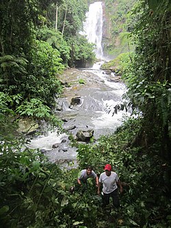
Valle Sagrado waterfall, Pangoa District
Country Flag of Peru.svg  Peru
Region Junín
Province Satipo
Capital Pangoa
Government
   Mayor Oscar Villazana Rojas
Time zone PET (UTC-5)
UBIGEO 120606

Pangoa District is one of eight districts of the province Satipo in Peru. [1]

Districts of Peru third level administrative subdivision of Peru

The districts of Peru are the third-level country subdivisions of Peru. They are subdivisions of the provinces, which in turn are subdivisions of the larger regions or departments. There are 1,838 districts in total.

Satipo Province Province in Junín, Peru

Satipo Province is the largest and easternmost province in the Junín Region, located in the central Amazon rainforest of Peru. Its capital is the town of Satipo.

Peru republic in South America

Peru, officially the Republic of Peru, is a country in western South America. It is bordered in the north by Ecuador and Colombia, in the east by Brazil, in the southeast by Bolivia, in the south by Chile, and in the west by the Pacific Ocean. Peru is a megadiverse country with habitats ranging from the arid plains of the Pacific coastal region in the west to the peaks of the Andes mountains vertically extending from the north to the southeast of the country to the tropical Amazon Basin rainforest in the east with the Amazon river.

Related Research Articles

Spuds is an unincorporated community in St. Johns County, Florida, United States. The community is situated in a region that depends economically on potato growing and other agriculture. As well as potatoes, the land around Spuds provides gladioli. A camp for German prisoners of war was built in Spuds during World War II, close to the intersection between State Roads 206 and 207.

Roman Catholic Archdiocese of Puerto Montt archdiocese

The Archdiocese of Puerto Montt is a Metropolitan See of the Roman Catholic church, in Chile. Its suffragan dioceses are: Osorno, San Carlos de Ancud and Punta Arenas.

San José de Ticllas District is one of fifteen districts of the province Huamanga in Peru.

María Parado de Bellido District is one of six districts of the province Cangallo in Peru.

Totos District is one of six districts of the province Cangallo in Peru.

Coronel Castañeda District is one of eight districts of the Parinacochas Province in Peru.

Cuyocuyo District is one of ten districts of the province Sandia in Peru.

Mazamari District is one of eight districts of the Satipo Province in Peru.

Pampa Hermosa District, Satipo District in Junín, Peru

Pampa Hermosa District is one of eight districts of the province Satipo in Peru.

Río Negro District is one of eight districts of the province Satipo in Peru.

Río Tambo District District in Junín, Peru

Río Tambo District is one of eight districts of the province Satipo of Peru.

Satipo District is one of eight districts of the Satipo Province in Peru.

Jaqui District is one of thirteen districts of the province Caravelí in Peru.

El Carmen District is one of ten districts of the province Churcampa, in Peru.

La Merced District, Churcampa District in Huancavelica, Peru

La Merced District is one of ten districts of the province Churcampa in Peru.

Paucarbamba District is one of ten districts of the province Churcampa in Peru.

San Miguel de Mayocc District is one of ten districts of the province Churcampa in Peru.

The following radio stations broadcast on AM frequency 1670 kHz: 1670 AM is a Regional broadcast frequency.

Corona Theatre cinema and theatre in Montreal, Quebec, Canada

The Corona Theatre, in Montreal, Quebec, Canada is located at 2490 Notre-Dame Street West in the Little Burgundy neighbourhood of the borough of Le Sud-Ouest.

Cathedral Basilica of Queen of Peace, San Miguel Church in San Miguel, El Salvador

The Cathedral Basilica of Queen of Peace, also called San Miguel Cathedral, is a Catholic church located in the city of San Miguel, El Salvador.

References

Coordinates: 11°28′18″S74°28′58″W / 11.4717°S 74.4829°W / -11.4717; -74.4829

Geographic coordinate system Coordinate system

A geographic coordinate system is a coordinate system that enables every location on Earth to be specified by a set of numbers, letters or symbols. The coordinates are often chosen such that one of the numbers represents a vertical position and two or three of the numbers represent a horizontal position; alternatively, a geographic position may be expressed in a combined three-dimensional Cartesian vector. A common choice of coordinates is latitude, longitude and elevation. To specify a location on a plane requires a map projection.