La Oroya | |
|---|---|
 | |
 Coat of arms | |
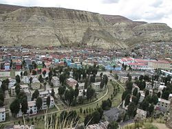
 La Oroya Location of La Oroya in the Yauli province | |
| Coordinates: 11°31′19″S75°54′36″W / 11.5220°S 75.9100°W | |
| Country | |
| Region | Junín |
| Province | Yauli |
| Founded | November 15, 1893 |
| Capital | La Oroya |
| Government | |
| • Mayor | Cesar Augusto Gutierrez Revilla |
| Area | |
• Total | 388.42 km2 (149.97 sq mi) |
| Elevation | 3,745 m (12,287 ft) |
| Population (2017) | |
• Total | 14,021 |
| • Density | 36/km2 (93/sq mi) |
| Time zone | UTC-5 (PET) |
| UBIGEO | 120801 |
| Website | munilaoroya.gob.pe |
La Oroya District is one of ten districts of the Yauli Province in Peru. It is a region that is rich in zinc, lead and copper.