San Luis de Shuaro District

Last updated
San Luis de Shuaro
District

San luis - panoramio.jpg

San Luis
District of San Luis de Shuaro.svg
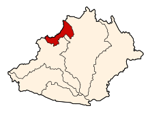
Location of San Luis de Shuaro in the Chanchamayo province
Country Flag of Peru.svg  Peru
Region Junín
Province Chanchamayo
Founded September 24, 1977
Capital San Luis de Shuaro
Government
   Mayor Luis Meza Reyes
Area
  Total 177.41 km2 (68.50 sq mi)
Elevation 721 m (2,365 ft)
Population (2005 census)
  Total 7,193
  Density 41/km2 (110/sq mi)
Time zone PET (UTC-5)
UBIGEO 120304

San Luis de Shuaro District is one of six districts of the province Chanchamayo in Peru. [1]

Districts of Peru third level administrative subdivision of Peru

The districts of Peru are the third-level country subdivisions of Peru. They are subdivisions of the provinces, which in turn are subdivisions of the larger regions or departments. There are 1,838 districts in total.

Chanchamayo Province Province in Junín, Peru

Chanchamayo or Chanchamayu is a province in northern Junín Region, in central Peru.

Peru republic in South America

Peru, officially the Republic of Peru, is a country in western South America. It is bordered in the north by Ecuador and Colombia, in the east by Brazil, in the southeast by Bolivia, in the south by Chile, and in the west by the Pacific Ocean. Peru is a megadiverse country with habitats ranging from the arid plains of the Pacific coastal region in the west to the peaks of the Andes mountains vertically extending from the north to the southeast of the country to the tropical Amazon Basin rainforest in the east with the Amazon river.

Related Research Articles

Claflin–Richards House

The Claflin–Richards House, also known as the Claflin–Gerrish–Richards House, is a historic First Period house located at 132 Main Street, Wenham, Massachusetts. It is now part of the nonprofit Wenham Museum and may be toured by appointment.

Llapa District is one of thirteen districts of the province San Miguel in Peru.

Villa Rica District is one of eight districts of the province Oxapampa in Peru.

Chanchamayo District District in Junín, Peru

Chanchamayo District is one of six districts of the province Chanchamayo in Peru. Its capital city is La Merced.

Perené District District in Junín, Peru

Perené District is one of six districts of the province Chanchamayo in Peru.

Huasicancha District is one of twenty-eight districts of the province Huancayo in Peru.

Ingenio District is one of twenty-eight districts of the province Huancayo in Peru.

Pilcomayo District is one of twenty-eight districts of the province Huancayo in Peru.

Pucará District is one of twenty-eight districts of the province Huancayo in Peru.

Sicaya District District in Junín, Peru

Sicaya District is one of twenty-eight districts of the province Huancayo in Peru.

Ricran District is one of thirty-four districts of the Jauja Province in Peru.

Chongos Bajo District is one of nine districts of the province Chupaca in Peru.

Chupaca District is one of nine districts of the province Chupaca in Peru.

Miraflores District is one of thirty-three districts of the province Yauyos in Peru.

Tomas District is one of thirty-three districts of the Yauyos Province in Peru.

Cocas District is one of thirteen districts of the province Castrovirreyna in Peru.

Huaytará District District in Huancavelica, Peru

Huaytará District is one of sixteen districts in Huaytará Province, Peru. Its seat is Huaytará.

Tambo District is one of sixteen districts of the province Huaytará in Peru.

Huimbayoc District District in San Martín, Peru

Huimbayoc or Wimpayuq (Quechua) is one of fourteen districts of the province San Martín in Peru.

The West Branch Nezinscot River is an 18.7-mile-long (30.1 km) river in Maine. It flows from Shagg Pond in Woodstock to its confluence with the East Branch in Buckfield. The resulting river, the Nezinscot, flows east to the Androscoggin River, which in turn flows southeast to the Kennebec River near its mouth at the Atlantic Ocean.

References

Coordinates: 10°53′16″S75°17′16″W / 10.8879°S 75.2879°W / -10.8879; -75.2879

Geographic coordinate system Coordinate system

A geographic coordinate system is a coordinate system that enables every location on Earth to be specified by a set of numbers, letters or symbols. The coordinates are often chosen such that one of the numbers represents a vertical position and two or three of the numbers represent a horizontal position; alternatively, a geographic position may be expressed in a combined three-dimensional Cartesian vector. A common choice of coordinates is latitude, longitude and elevation. To specify a location on a plane requires a map projection.