Location | Bodmin Moor, Cornwall |
---|---|
Coordinates | 50°34′06″N4°38′33″W / 50.56833°N 4.64250°W Coordinates: 50°34′06″N4°38′33″W / 50.56833°N 4.64250°W |
Type | Megalithic enclosure |
History | |
Periods | Neolithic / Bronze Age |
King Arthur's Hall is a megalithic enclosure on Bodmin Moor in Cornwall, England. It is thought to be a late Neolithic or early Bronze Age ceremonial site. [1]
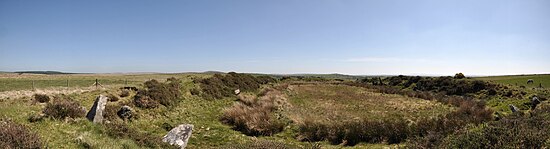
The monument consists of fifty-six stones arranged in a rectangle with a bank of earth around them and measures approximately 20m by 47m. The interior fills with water and a contemporary ground level has not been established. [2] It has suffered damage by cattle in the past and is now protected by a gated fence. It can be reached by footpaths east of St Breward.
The surrounding area contains many stone circles, hut circles, cairns and cists. [3]
In the absence of any archaeological finds, its origin and use is only speculative. [4] A similar enclosure exists in Brittany which was a Bronze Age cremation site, but a similar rampart construction at Lough Gur in Ireland suggests an earlier Neolithic date. [4] It has even been suggested that it was merely a medieval cattle pound, but the effort required to build the bank and to erect the slabs suggests that it had a more important function. [4]
Some clearance and investigation of King Arthur's Hall was conducted by members of The Heritage Trust in 2013/14. [4] Their work revealed a revetment wall built to retain the inner bank. [4] It was concluded that over time the earth had covered over the top of the revetment wall and that around 140 upright stones now lie buried, recumbent, or standing at an angle. [4] It was suggested that the structure originally formed a tank which filled with water, possibly for ritualistic use. [4]
In September 2022 Cornwall AONB’s Monumental Improvement project worked with the Cornwall Archaeological Unit to conduct an excavation, to determine when the structure was built. [5]
Bodmin Moor is a granite moorland in north-eastern Cornwall, England. It is 208 square kilometres (80 sq mi) in size, and dates from the Carboniferous period of geological history. It includes Brown Willy, the highest point in Cornwall, and Rough Tor, a slightly lower peak. Many of Cornwall's rivers have their sources here. It has been inhabited since at least the Neolithic era, when primitive farmers started clearing trees and farming the land. They left their megalithic monuments, hut circles and cairns, and the Bronze Age culture that followed left further cairns, and more stone circles and stone rows. By medieval and modern times, nearly all the forest was gone and livestock rearing predominated.
There are three related types of Neolithic earthwork that are all sometimes loosely called henges. The essential characteristic of all three is that they feature a ring-shaped bank and ditch, with the ditch inside the bank. Because the internal ditches would have served defensive purposes poorly, henges are not considered to have been defensive constructions. The three henge types are as follows, with the figure in brackets being the approximate diameter of the central flat area:
Durrington Walls is the site of a large Neolithic settlement and later henge enclosure located in the Stonehenge World Heritage Site in England. It lies 2 miles (3.2 km) north-east of Stonehenge in the parish of Durrington, just north of Amesbury in Wiltshire. The henge is the second-largest Late Neolithic palisaded enclosure known in the United Kingdom, after Hindwell in Wales.
A tor enclosure is a prehistoric monument found in the southwestern part of Great Britain. These monuments emerged around 4000 BCE in the early Neolithic.
Grimspound is a late Bronze Age settlement, situated on Dartmoor in Devon, England. It consists of a set of 24 hut circles surrounded by a low stone wall. The name was first recorded by the Reverend Richard Polwhele in 1797; it was probably derived from the Anglo-Saxon god of war, Grim.
Navan Fort is an ancient ceremonial monument near Armagh, Northern Ireland. According to tradition it was one of the great royal sites of pre-Christian Gaelic Ireland and the capital of the Ulaidh. It is a large circular hilltop enclosure—marked by a bank and ditch—inside which is a circular mound and the remains of a ring barrow. Archeological investigations show that there were once buildings on the site, including a huge roundhouse-like structure that has been likened to a temple. In a ritual act, this timber structure was filled with stones, deliberately burnt down and then covered with earth to create the mound which stands today. It is believed that Navan was a pagan ceremonial site and was regarded as a sacred space. It features prominently in Irish mythology, especially in the tales of the Ulster Cycle. According to the Oxford Dictionary of Celtic Mythology, "the [Eamhain Mhacha] of myth and legend is a far grander and mysterious place than archeological excavation supports".
In archaeology, an enclosure is one of the most common types of archaeological site – It is any area of land separated from surrounding land by earthworks, walls or fencing. Such a simple feature is found all over the world and during almost all archaeological periods. They may be few metres across or be large enough to encompass whole cities.
The Nine Ladies is a stone circle located on Stanton Moor in Derbyshire in the English East Midlands. The Nine Ladies is part of a tradition of stone circle construction that spread throughout much of Britain, Ireland, and Brittany during the Late Neolithic and Early Bronze Ages, over a period between 3300 and 900 BCE. The purpose of such monuments is unknown, although archaeologists speculate that the stones represented supernatural entities for the circles' builders.
The Hurlers is a group of three stone circles in the civil parish of St Cleer, Cornwall, England, UK. The site is half-a-mile (0.8 km) west of the village of Minions on the eastern flank of Bodmin Moor, and approximately four miles (6 km) north of Liskeard at grid reference SX 258 714.
Figsbury Ring is an 11.2 hectare biological Site of Special Scientific Interest in Wiltshire, notified in 1975. It is owned and managed by the National Trust.
Doll Tor is a stone circle located just to the west of Stanton Moor, near the village of Birchover, Derbyshire in the English East Midlands. Doll Tor is part of a tradition of stone circle construction that spread throughout much of Britain, Ireland, and Brittany during the Late Neolithic and Early Bronze Ages, over a period between 3300 and 900 BCE. The purpose of such monuments is unknown, although archaeologists speculate that the stones represented supernatural entities for the circles' builders.
Rough Tor, or Roughtor, is a tor on Bodmin Moor, Cornwall, United Kingdom. The site is composed of the tor summit and logan stone, a neolithic tor enclosure, a large number of Bronze Age hut circles, and some contemporary monuments.
Craddock Moor Stone Circle or Craddock Moor Circle is a stone circle located near Minions on Bodmin Moor in Cornwall, UK. It is situated around half a mile Northwest of The Hurlers.
Stannon stone circle is a stone circle located near St. Breward on Bodmin Moor in Cornwall, England.
Fernacre, also known as Fernacre stone circle or Fernacre circle, is a stone circle located on the slopes of the De Lank River, 1.25 miles (2.01 km) northeast of St Breward on Bodmin Moor in Cornwall in the United Kingdom.
The stone circles in the British Isles and Brittany are a megalithic tradition of monuments consisting of standing stones arranged in rings. These were constructed from 3300 to 900 BCE in Britain, Ireland and Brittany. It has been estimated that around 4,000 of these monuments were originally constructed in this part of north-western Europe during this period. Around 1,300 of them are recorded, the others having been destroyed.
A ring cairn is a circular or slightly oval, ring-shaped, low embankment, several metres wide and from 8 to 20 metres in diameter. It is made of stone and earth and was originally empty in the centre. In several cases the middle of the ring was later used. The low profile of these cairns is not always possible to make out without conducting excavations.
Stowe's Hill is an elongated hill, 381 metres (1,250 ft) high, located on the eastern edge of Bodmin Moor in the county of Cornwall, England.
Leskernick Hill is on Bodmin Moor in Cornwall, UK. It is 329m high and has grid reference SX183803.. Leskernick Hill is within the Cornwall AONB as part of Area 12: Bodmin Moor in the parish of Altarnun. It lies in an area of moorland that is common land. Its parent hill is Brown Willy and it is within sight of Rough Tor and other local tors
Media related to King Arthur's Hall at Wikimedia Commons