King Edward Street

Last updated

Oxford map small.svg
Blue pog.svg
Location of King Edward Street within central Oxford
The south end of King Edward Street, looking towards Oriel College, to the east, in Oriel Square. The south end of King Edward Street, towards Oriel College.jpg
The south end of King Edward Street, looking towards Oriel College, to the east, in Oriel Square.
Portrait bust of Cecil Rhodes, former student at Oriel College, on the 1st floor of 6 King Edward Street. Rhodes' portrait bust.JPG
Portrait bust of Cecil Rhodes, former student at Oriel College, on the 1st floor of 6 King Edward Street.

King Edward Street is a street running between the High Street to the north and Oriel Square to the south in central Oxford, England. [1]

To the east is the "Island" site of Oriel College, one of the colleges of Oxford University. To the west are shops, including Shepherd & Woodward, the leading University outfitters, fronting onto the High Street.

King Edward Street is officially designated as part of the A420 road due to the blockage of the High Street to normal traffic.

The street was only created in 1872–73 by Oriel College when 109 and 110 High Street were demolished, so it is much wider than other older streets off the High Street. The buildings were mostly designed by Frederick Codd. [2]

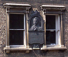
On the wall of the first floor of No. 6, there is a large metal plaque with a portrait of Cecil Rhodes; underneath is the inscription:

In this house, the Rt. Hon Cecil John Rhodes kept academical residence in the year 1881. This memorial is erected by Alfred Mosely in recognition of the great services rendered by Cecil Rhodes to his country. [3]

On No. 14 lived Felix Yusupov, one of the murderers of Grigori Rasputin. [4]

Related Research Articles

<span class="mw-page-title-main">Oriel College, Oxford</span> College of the University of Oxford

Oriel College is a constituent college of the University of Oxford in Oxford, England. Located in Oriel Square, the college has the distinction of being the oldest royal foundation in Oxford. In recognition of this royal connection, the college has also been historically known as King's College and King's Hall. The reigning monarch of the United Kingdom is the official visitor of the college.

<span class="mw-page-title-main">University College, Oxford</span> Constituent College of Oxford University

University College is a constituent college of the University of Oxford in England. It has a claim to being the oldest college of the university, having been founded in 1249 by William of Durham.

<span class="mw-page-title-main">Cecil Rhodes</span> British mining magnate and politician (1853–1902)

Cecil John Rhodes was a British mining magnate and politician in southern Africa who served as Prime Minister of the Cape Colony from 1890 to 1896.

Carfax, Oxford Crossroads; central area of Oxford in England

Carfax is the junction of St Aldate's (south), Cornmarket Street (north), Queen Street (west) and the High Street (east) in Oxford, England. It is considered to be the centre of the city. The name "Carfax" derives from the Latin quadrifurcus via the French carrefour, both of which mean "crossroads". The Carfax Tower, also known as St. Martin's Tower is a prominent landmark and provides a look-out over the town.

St Mary Hall, Oxford Former hall of the University of Oxford

St Mary Hall was a medieval academic hall of the University of Oxford. It was associated with Oriel College from 1326 to 1545, but functioned independently from 1545 until it was incorporated into Oriel College in 1902.

<span class="mw-page-title-main">Herbert Baker</span> English architect

Sir Herbert Baker was an English architect remembered as the dominant force in South African architecture for two decades, and a major designer of some of New Delhi's most notable government structures. He was born and died at Owletts in Cobham, Kent.

Basil Champneys was an English architect and author whose most notable buildings include Manchester's John Rylands Library, Somerville College Library (Oxford), Newnham College, Cambridge, Lady Margaret Hall, Oxford, Mansfield College, Oxford and Oriel College, Oxford's Rhodes Building.

<span class="mw-page-title-main">Beaumont Palace</span>

Beaumont Palace, built outside the north gate of Oxford, was intended by Henry I about 1130 to serve as a royal palace conveniently close to the royal hunting-lodge at Woodstock. Its former presence is recorded in Beaumont Street, Oxford. Set into a pillar on the north side of the street, near Walton Street, is a stone with the inscription: "Near to this site stood the King's Houses later known as Beaumont Palace. King Richard I was born here in 1157 and King John in 1166". The "King's House" was the range of the palace that contained the king's lodgings.

<span class="mw-page-title-main">High Street, Oxford</span> Street in Oxford, England

The High Street in Oxford, England, known locally as the High, runs between Carfax, generally seen as the centre of the city, and Magdalen Bridge to the east.

The Oriel Square tennis court was a real tennis court that was located in Oriel Square, central Oxford, England. The Liber Albus mentions the Oriel court being in Vinehall Lane in 1577.

<span class="mw-page-title-main">Merton Street</span> Street in central Oxford, England

Merton Street is a historic and picturesque cobbled street in central Oxford, England. It joins the High Street at its northeastern end, between the Ruskin School of Drawing and Fine Art and the Eastgate Hotel at the historic east gate of the city. It then runs east–west, parallel and to the south of the High Street for most of its length.

<span class="mw-page-title-main">Oriel Square</span>

Oriel Square, formerly known as Canterbury Square, is a square in central Oxford, England, located south of the High Street. The name was changed after the Second World War at the request of Oriel College which maintained that the square had originally been known as Oriel Square.

<span class="mw-page-title-main">Alfred Street</span> Street in central Oxford, England

Alfred Street is a street running between the High Street to the north and the junction with Blue Boar Street and Bear Lane at the southern end, in central Oxford, England. To the south is Christ Church, one of Oxford University's historic colleges.

<span class="mw-page-title-main">Bear Lane</span> Street in central Oxford, England

Bear Lane is a short historic street in central Oxford, England. The lane is located just north of Christ Church. It runs between the junction of Blue Boar Street and Alfred Street to the west, and King Edward Street and the north of Oriel Square to the east.

<span class="mw-page-title-main">Oriel Street</span> Street in central Oxford, England

Oriel Street is a narrow but historic street running between the High Street to the north and Oriel Square to the south in central Oxford, England. The street is now blocked off to traffic by bollards at the High Street end.

<span class="mw-page-title-main">Magpie Lane, Oxford</span> Lane in central Oxford, England

Magpie Lane is a narrow historic lane in central Oxford, England. It leads south from the High Street where it is at its narrowest, now completely pedestrianised as a pavement, and north from the cobbled Merton Street.

Dead Mans Walk, Oxford

Dead Man's Walk is a footpath running east–west in central Oxford, England, situated immediately to the south of Merton College and just outside the old city wall, with Corpus Christi College at the western end. To the north, Grove Walk connects with Merton Street through a gateway. Immediately to the south is Merton Field with Merton Walk connecting to the wide tree-lined Broad Walk, which runs parallel with Dead Man's Walk. Beyond that is Christ Church Meadow.

<span class="mw-page-title-main">Rhodes House</span>

Rhodes House is a building part of the University of Oxford in England. It is located on South Parks Road in central Oxford, and was built in memory of Cecil Rhodes, an alumnus of the university and a major benefactor. It is listed Grade II* on the National Heritage List for England.

New Road, Oxford Street in west central Oxford, England

New Road is a street in west central Oxford, England. It links Park End Street and Worcester Street to the west with Queen Street and Castle Street to the east. To the south is Oxford Castle and the former Oxford Prison, now a Malmaison hotel. To the north is Nuffield College, a graduate college of Oxford University. At the eastern end on the south side is New County Hall, the headquarters of Oxfordshire County Council.

Rhodes Must Fall Anti-apartheid protest movement regarding statues at the University of Cape Town in South Africa

Rhodes Must Fall was a protest movement that began on 9 March 2015, originally directed against a statue at the University of Cape Town (UCT) that commemorates Cecil Rhodes. The campaign for the statue's removal received global attention and led to a wider movement to "decolonise" education across South Africa. On 9 April 2015, following a UCT Council vote the previous night, the statue was removed.

References

  1. King Edward Street, The High, Oxford, UK.
  2. Sherwood, Jennifer; Pevsner, Nikolaus (1974). The Buildings of England: Oxfordshire. Penguin Books. p. 309. ISBN   0-14-071045-0.
  3. Inscriptions in Oxford, OxfordHistory.org.uk.
  4. NY Times

Coordinates: 51°45′07″N1°15′16″W / 51.7520°N 1.2545°W / 51.7520; -1.2545