| Geography | |
|---|---|
| Location | Coral Sea |
| Coordinates | 14°05′46″S144°19′59″E / 14.096°S 144.333°E Coordinates: 14°05′46″S144°19′59″E / 14.096°S 144.333°E |
| Adjacent bodies of water | Bathurst Bay |
| Administration | |
| State | Queensland |
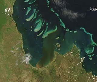
King Island is part of the Great Barrier Reef Marine Park at the tip of Cape Melville, Queensland in Bathurst Bay.
It is northeast of Denham Island and Flinders Island in the Flinders Group National Park. King Island (Erobin) lies off the coast of Queensland. [1]
Queensland is the second largest state in Australia. It contains 472 separate protected areas with a total land area of 69,388 km2 (26,791 sq mi). 223 of these are National parks, which is the highest number of any Australian state or territory, totalling 65,871 km2 (25,433 sq mi). Seven others are Scientific National Parks, totalling 522 km2 (202 sq mi).

Flinders Chase National Park is a protected area in the Australian state of South Australia located at the west end of Kangaroo Island about 177 kilometres west-south west of the state capital of Adelaide and 110 kilometres west of the municipal seat of Kingscote. It is a sanctuary for endangered species and home to a few geological phenomena. It was the second national park to be declared in South Australia.

Flinders Group is a national park in Queensland (Australia), 1,745 km northwest of Brisbane.

South Cumberland Islands is a national park in Queensland, Australia, 831 km northwest of Brisbane. It is famous for the Marine stingers which can be found in the waters of the park between October and May.
Moreton Island is an island on the eastern side of Moreton Bay on the coast of South East Queensland, Australia. The Coral Sea lies on the east coast of the island. Moreton Island lies 58 kilometres (36 mi) northeast of the Queensland capital, Brisbane. 95% of the island is contained within a national park and a popular destination for day trippers, four wheel driving, camping, recreational angling and whale watching and a 75-minute ferry ride from Brisbane. It is the third largest sand island in the world. Together with Fraser Island, Moreton Island forms the largest sand structure in the world. It was the traditional country of the Ngugi before the onset of colonization.
Flinders may refer to:

Flinders Island, the largest island in the Furneaux Group, is a 1,367-square-kilometre (528 sq mi) island in the Bass Strait, northeast of the island of Tasmania. Flinders Island is part of the state of Tasmania, Australia. It is 54 kilometres (34 mi) from Cape Portland and is located on 40° south, a zone known as the Roaring Forties.
Bribie Island is the smallest and most northerly of three major sand islands forming the coastline sheltering the northern part of Moreton Bay, Queensland, Australia. The others are Moreton Island and North Stradbroke Island. Bribie Island is 34 kilometres long, and 8 kilometres at its widest. Archibald Meston believed that the name of the island came from a corruption of a mainland word for it, Boorabee. meaning 'koala bear'.
Princess Charlotte Bay is a large bay on the east coast of Far North Queensland at the base of Cape York Peninsula, 350 km north northwest of Cairns. Princess Charlotte Bay is a part of the Great Barrier Reef Marine Park and it is a habitat for the dugong.
Denham Island is part of the Great Barrier Reef Marine Park at the tip of Cape Melville, Queensland in Bathurst Bay.
Flinders Island is the name given to an island that forms part of the Great Barrier Reef Marine Park at the tip of Cape Melville, Queensland in Bathurst Bay. The original indigenous name was Wurriima.

Stanley Island is part of the Great Barrier Reef Marine Park at the tip of Cape Melville, Queensland in Bathurst Bay. It is located North of Denham Island and Flinders Island in the Flinders Group National Park in Princess Charlotte Bay. The island is a popular tourist destination with fine anchorage between the islands and along various coastal stretches. Stanley Island was first declared a national park in 1939.

Captain Matthew Flinders was an English navigator and cartographer who led the second circumnavigation of New Holland that he would subsequently call "Australia or Terra Australis" and identified it as a continent. Abel Tasman had circumnavigated it more widely in 1642-43 and had charted its north coast in 1644.
Flinders Reef is a small isolated reef near Moreton Island, 5 kilometres (3 mi) north-east of Cape Moreton in South East Queensland, Australia. It has the highest number of coral species of any subtropical reef system along Australia's east coast and is the nearest true coral reef to Brisbane. Flinders Reef is one of Queensland's most popular dive sites. The reef is located within the Moreton Bay Marine Park and is monitored by the Reef Check conservation program.

Flinders View is a suburb in the City of Ipswich, Queensland, Australia. At the 2016 Australian Census, the suburb recorded a population of approximately 5,800.

Pumicestone Passage, also known as the Pumicestone Channel, is a narrow waterway between Bribie Island and the mainland in Queensland, Australia. The northern extent of the passage is at Caloundra, while at the south is Deception Bay.

The Teviot Range, also referred to as the Flinders Peak Group, is a mountain range located on the northern edge of the Scenic Rim Region, south west of Logan City and south east of the City of Ipswich in South East Queensland, Australia.

Peak Crossing is a locality split between the City of Ipswich and the Scenic Rim Region of Queensland, Australia. In the 2011 census, Peak Crossing had a population of 768 people.
The Djindubari, also written Jindoobarrie or Joondubarri, were an indigenous Australian people of southern Queensland, whose traditional lands were located on Bribie Island. They are thought to be a horde or clan of the Undanbi.
The Percy Group is a locality consisting of a number of islands in the Coral Sea within the Isaac Region, Queensland, Australia. In the 2016 census, The Percy Group had a population of 0 people. The islands are uninhabitated as they are within national parks and conservation parks.
| This Queensland protected areas related article is a stub. You can help Wikipedia by expanding it. |