
René-Robert Cavelier, Sieur de La Salle was a 17th-century French explorer and fur trader in North America. He explored the Great Lakes region of the United States and Canada, the Mississippi River, and the Gulf of Mexico. He is best known for an early 1682 expedition in which he canoed the lower Mississippi River from the mouth of the Illinois River to the Gulf of Mexico and claimed the entire Mississippi River basin for France.

The Rideau River, is a river in Eastern Ontario, Canada. The river flows north from Upper Rideau Lake and empties into the Ottawa River at the Rideau Falls in Ottawa, Ontario. Its length is 146 kilometres (91 mi).

The Humber River is a river in Southern Ontario, Canada. It is in the Great Lakes Basin, is a tributary of Lake Ontario and is one of two major rivers on either side of the city of Toronto, the other being the Don River to the east. It was designated a Canadian Heritage River on September 24, 1999.

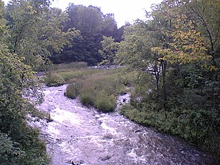
The Mississippi River is a tributary of the Ottawa River in Eastern Ontario, Canada. It is 200 kilometres (120 mi) in length from its source at Mackavoy Lake, has a drainage area of 4,450 square kilometres (1,720 sq mi), and has a mean discharge of 40 cubic metres per second (1,400 cu ft/s). There are more than 250 lakes in the watershed.

The Grand River is a large river in Southwestern Ontario, Canada. It also lies along the western fringe of the Golden Horseshoe region of Ontario which overlaps the eastern portion of southwestern Ontario along the length of this river. From its source near Wareham, Ontario, it flows south through Grand Valley, Fergus, Elora, Waterloo, Kitchener, Cambridge, Paris, Brantford, Caledonia, and Cayuga before emptying into the north shore of Lake Erie south of Dunnville at Port Maitland. One of the scenic and spectacular features of the river is the falls and Gorge at Elora.
The Indian River is a river in Lanark County in Eastern Ontario, Canada. It is in the Saint Lawrence River drainage basin and is a left tributary of the Mississippi River.

The York River is a river in Renfrew County, Hastings County and Haliburton County in Ontario, Canada. The river is in the Saint Lawrence River drainage basin, and flows from the southern extension of Algonquin Provincial Park to the Madawaska River.
Black Creek may refer to:
Crooked Creek may refer to:
The Clyde River is a river in Lanark County in Eastern Ontario, Canada. It is in the Saint Lawrence River drainage basin, is a left tributary of the Mississippi River, and was named after the River Clyde in Scotland.
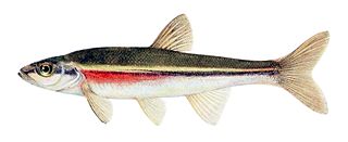
The redside dace is a species of ray-finned fish in the family Cyprinidae, found in the United States and Canada. It is unique among minnows, being the only species to routinely feed on flying insects by leaping from water. Thus, it acts as a conduit for nutrient transfers between terrestrial and aquatic environments. The species can be used as an ecosystem health indicator, as it is sensitive to environmental disturbances.
Mississippi Lake is a lake in Lanark County in Ontario, Canada. Ontario's Mississippi River flows northeast and north through the lake. Several small creeks including Cranberry Creek, McCrearys Creek, and McGibbon Creek drain into the lake from adjoining forest and agricultural land. The lake is distinctive for having one side that is part of the Canadian shield, while the other is mostly limestone. The lake is a remnant of the old Champlain Sea, which flooded eastern Ontario at the end of last ice age. The former shoreline of the sea can still be traced inland from the north shore of the lake.
Kings Creek is a creek in eastern Ontario, Canada. It is a right tributary of the Jock River. It should not be confused with Kings Creek, a tributary of the Mississippi River (Ontario) nearby to the west.
Summit Lake is a lake in the Madawaska Highlands in North Frontenac, Frontenac County, Ontario, Canada, about 3.5 kilometres (2.2 mi) northwest of the community of Ompah.

Bobs Lake is a lake in the Saint Lawrence River drainage basin in the township of North Frontenac, Frontenac County in eastern Ontario, Canada.

This is the outline of the geography of the city of Ottawa, the capital of Canada. Ottawa's current borders were formed in 2001, when the former city of Ottawa amalgamated with the ten other municipalities within the former Regional Municipality of Ottawa–Carleton. Ottawa is now a single-tiered census division, home to 870,250 people.
The Little Clyde River is a river in the municipality of Lanark Highlands, Lanark County in Eastern Ontario, Canada. It is in the Saint Lawrence River drainage basin, is a right tributary of the Clyde River, and was named after the River Clyde in Scotland.

The Toronto waterway system comprises a series of natural and man-made watercourses in the Canadian city of Toronto. The city is dominated by a large river system spanning most of the city including the Don River, Etobicoke Creek, Highland Creek, the Humber River, Mimico Creek and the Rouge River.


