Related Research Articles

The Sydney Harbour Bridge is a steel through arch bridge in Sydney, New South Wales, Australia, spanning Sydney Harbour from the central business district (CBD) to the North Shore. The view of the bridge, the Harbour, and the nearby Sydney Opera House is widely regarded as an iconic image of Sydney, and of Australia itself. Nicknamed "The Coathanger" because of its arch-based design, the bridge carries rail, vehicular, bicycle and pedestrian traffic.

The Hume Highway, including the sections now known as the Hume Freeway and the Hume Motorway, is one of Australia's major inter-city national highways, running for 840 kilometres (520 mi) between Melbourne in the southwest and Sydney in the northeast. Upgrading of the route from Sydney's outskirts to Melbourne's outskirts to dual carriageway was completed on 7 August 2013.

Princes Highway is a major road in Australia, extending from Sydney via Melbourne to Adelaide through the states of New South Wales, Victoria and South Australia. It has a length of 1,941 kilometres (1,206 mi) or 1,898 kilometres (1,179 mi) via the former alignments of the highway, although these routes are slower and connections to the bypassed sections of the original route are poor in many cases.
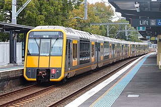
The Eastern Suburbs & Illawarra Line is a commuter railway line on the Sydney Trains network in the eastern and southern suburbs of Sydney. The line was constructed in the 1880s to Wollongong to take advantage of agricultural and mining potentials in the Illawarra area. In March 1926, it became the first railway in New South Wales to run electric train services.

The West Gate Freeway is a major freeway in Melbourne, the busiest urban freeway and the busiest road in Australia, carrying upwards of 200,000 vehicles per day. It links Geelong and Melbourne's western suburbs to central Melbourne and beyond. It is also a link between Melbourne and the west and linking industrial and residential areas west of the Yarra River with the city and port areas. The West Gate Bridge is a part of the freeway.

The Eastern Suburbs Railway (ESR) is a commuter railway line in Sydney constructed in the 1970s. It is operated by Sydney Trains and has stations at Martin Place, Kings Cross, Edgecliff and Bondi Junction. In addition, it has dedicated platforms at Town Hall, Central and Redfern stations. All of these stations are underground. The Eastern Suburbs railway connects with the Illawarra line at Erskineville, forming the Eastern Suburbs & Illawarra Line. The line features turnbacks at Central, Martin Place and Bondi Junction. There was also previously a rarely used cross-over at Edgecliff. It operates a service every 3 to 5 minutes during weekday peak hours and 8 to 10 minutes at all other times.

The Eastern Freeway is an urban freeway in eastern Melbourne, the state capital of Victoria, Australia. It is one of the most important freeways in terms of commuting to the city, connecting Alexandra Parade and Hoddle Street in the inner suburbs, with EastLink tollway farther east. It consists of between three and six lanes in each direction, also an inbound transit lane reserved for vehicles with two or more occupants during peak hours.
Transurban is a road operator company that manages and develops urban toll road networks in Australia, Canada and the United States. It is listed on the Australian Securities Exchange (ASX), and is the world’s largest toll road operator.

The Cross City Tunnel is a 2.2-kilometre long (1.4 mi) twin-road tunnel tollway located in Sydney, New South Wales, Australia. The tunnel links Darling Harbour on the western fringe of the central business district to Rushcutters Bay in the Eastern Suburbs. Each of the twin tunnels has a different alignment, with the westbound tunnel running underneath William and Park streets and the eastbound tunnel running underneath Bathurst Street.
City West Link is a 5.0-kilometre (3.1 mi) link road connecting Parramatta Road and the Western Distributor through the Inner West suburbs of Sydney, New South Wales, Australia. It was bypassed by the WestConnex project upon its completion in November 2023. This name covers a few consecutive roads and is widely known to most drivers, but the entire allocation is also known – and signposted – by the names of its constituent parts: Wattle Street, Dobroyd Parade, City West Link proper and The Cresent.

The Eastern Distributor is a 4.7-kilometre-long (2.9 mi) motorway in Sydney, New South Wales, Australia. Part of the M1 and the Sydney Orbital Network, the motorway links the Sydney central business district with the south-east and Sydney Airport. The Eastern Distributor separates Sydney's Eastern Suburbs from Sydney's Inner-Southern Suburbs. The centre-piece is a 1.7 km (1.1 mi) tunnel running from Woolloomooloo to Surry Hills. Built as a build-own-operate-transfer project, it is 75.1% owned by Transurban.

William Street is a 1.4-kilometre-long (0.87 mi) major thoroughfare in Sydney, New South Wales, Australia. The street was named in honour of king William IV of the United Kingdom of Great Britain and Ireland upon its opening in 1834.

Cahill Expressway is an urban freeway in Sydney and was the first freeway constructed in Australia, with the first section, from the Bradfield Highway to Conservatorium Place being opened to traffic in March 1958. It links the southern end of the Sydney Harbour Bridge, via an elevated roadway, a tunnel and cuttings between the Royal Botanic Garden and The Domain, to Woolloomooloo in Sydney's inner-eastern suburbs.

The M4 Motorway is a 55-kilometre (34 mi) series of partially tolled dual carriageway motorways in Sydney designated as route M4. The M4 designation is part of the wider A4 and M4 route designation, the M4 runs parallel and/or below ground to Great Western Highway, Parramatta Road and City West Link, which are part of route A44.

The M5 Motorway is a 28.8-kilometre (17.9 mi) series of tolled motorways located in Sydney, New South Wales designated as route M5. It is part of the Sydney Orbital Network.
Southern Cross Drive is a 4.8 km (3 mi) dual carriage untolled motorway in Sydney, New South Wales, Australia. Part of the M1 and Sydney Orbital Network, the road, a freeway that opened in 1969, links South Dowling Street at Kensington in the north to General Holmes Drive at Sydney Airport in the south.

Western Distributor is a 4.3-kilometre-long (2.7 mi) grade-separated motorway that is primarily elevated for the majority of its route on the western fringe of the Sydney central business district. It links the southern end of Bradfield Highway at the Sydney Harbour Bridge to Victoria Road in Rozelle, at its western terminus near White Bay. It is a constituent part of the A4 route.
CIMIC Group Limited is an engineering-led construction, mining, services and public private partnerships leader working across the lifecycle of assets, infrastructure and resources projects.
Yarra Bank Highway is a short urban highway in central Melbourne, Australia. It runs parallel to the Yarra River and provides an important alternate route to CityLink's Domain and Burnley Tunnels, used by trucks carrying hazardous loads prohibited from the tunnels, and provides another route when the tunnels are closed for maintenance. Prior to the construction of CityLink, the highway provided the main link between the Monash Freeway and the West Gate Freeway. It is known along its route as Power Street, City Road, Alexandra Avenue and Olympic Boulevard.

The Stockton Bridge is a road bridge that carries Nelson Bay Road across the Hunter River, between Kooragang and Stockton in the Hunter Region of New South Wales, Australia. The bridge and Nelson Bay Road serve as the main transport route between Newcastle and the Tilligerry and Tomaree peninsulas in Port Stephens. The bridge carries motor vehicles and a central grade-separated shared cycleway and footpath.
References
- 1 2 Kennedy, Brian (1982). Subterranean Sydney. Frenchs Forest: AH & AW Reed. pp. 71–74. ISBN 058950312X.
- ↑ Kings Cross Road Tunnel Project Department of Main Roads Annual Report for year ended 30 June 1971 page 12
- ↑ Kings Cross Road Tunnel Department of Main Roads Annual Report for year ended 30 June 1972 page 12
- ↑ Kings Cross Road Tunnel Department of Main Roads Annual Report for year ended 30 June 1973 page 11
- ↑ Kings Cross Road Tunnel Department of Main Roads Annual Report for year ended 30 June 1974 page 11
- ↑ Kings Cross tunnel opening Sydney Morning Herald 16 December 1975 page 7
- ↑ Kings Cross Road Tunnel Project Department of Main Roads Annual Report for year ended 30 June 1976 page 10
- ↑ Space over Kings Cross tunnel to be sold Canberra Times 10 October 1986 page 14
- ↑ Walker's $27.5m Kings Cross deal Australian Financial Review 9 January 1998