Kitselas First Nation

Last updated

Kitselas First Nation is the band government of the Kitselas subgroup of the Tsimshian. The band government is based at Gitaus [1] in the Skeena Valley (near Kitselas, British Columbia, which is named for them) in the Skeena River valley to the northeast of the city of Terrace, British Columbia, Canada. Though there is no Tsimshian tribal council, they are a participant in the Tsimshian First Nations treaty council. [2]

Contents

History

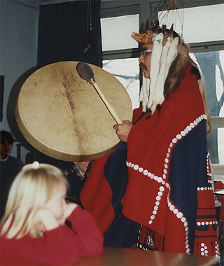
The Kitselas First Nation have inhabited their lands for at least 5,000 years according to archaeological evidence. [3] Their name is derived from Gitselasu which means ‘people of the canyon.’ [3] The language of the Kitselas is Sm’algyax, which is the language for all bands of the Tsimshian Nation. [3] The history of the Kitselas is told through narratives called adawx. [3] Adawx talk about their origins through their perspective. Everyone belonging to the Tsimshian First Nation belongs to a clan or sub-clan. The Kitselas First Nation has four clans: Gispudwada (Killerwhale), Laxgiboo (Wolf), Laxsgiik (Eagle), and Ganhada (Raven). [3]

Overview

Map of the Skeena River. Skeena river basin map.png
Map of the Skeena River.

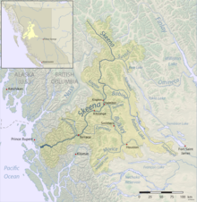
The earliest record of European contact with the Kitselas was in the 1700s with Russian missionaries and fur traders. [4] In 1792, British explorer George Vancouver mapped the coast of British Columbia for more trading ships to arrive and more traders ventured inland. This directly affected the Kitselas because it meant more people would be venturing onto their land. This would worsen in 1843 when the Hudson's Bay Company (HBC) created boundaries in British Columbia which essentially divided up native land in order for it to be settled or used by the British. The Kitselas held a strategic position on the Skeena River that allowed them to control trade with HBC because the river flowed inland from the coast. [5] In 1858, James Douglas became the first governor of British Columbia and mapped out the Indian reserves. In 1859, the Skeena pass was claimed by William Downie for railroads, which meant more exploration along the Skeena River and Kitselas land continued to decrease. [6] In 1864, Douglas was replaced by Joseph Trutch who reduced the size of reservations and created policies that were meant to discriminate against Indians. In 1867, the Constitution Act was passed which said that Canada was responsible for natives and that they had to reserve land for them. In 1872, the British took control of the Skeena River from the Kitselas, so they could no longer charge for people to enter the canyon. [6] Tsimshian and Nisga’a Chiefs travel to Victoria in 1887 to plead for treaties and self governance, but are not obliged. [6] In 1901, Kitselas Reserve territory was finalized and their land was reduced from 220,000 hectares to 1200 hectares. [6] In 1904, the Homestead Act claimed that anybody except natives and Chinese could have 160 acres of land anywhere along the Skeena River for free. In 1927, Canada made it illegal for natives to fight for their land. [6] In 1931, Tsimshian and Haida formed the Native Brotherhood where they discussed their grievances and this group still exists today. [7] In 1946, the flu epidemic killed many Kitselas political leaders and the fight for their rights did not start again until the 1980s. [6] In 1951, the Indian Act was changed and potlatch and claims to land were made legal again. [6] In 1982, the Constitution Act recognized the rights of Indians. In 1984, Tsimshian Tribal Council was formed of 7 bands in the Northwest and together they would fight for the rights and lands that they had taken away from them by the British. [6]

Kitselas Treaty

Kitselas has been working toward a treaty since 1993. [8] The goal of the Kitselas Treaty is to get Kitselas out from under the Indian Act and make the nation self-governing. [8] The Indian Act was passed in 1876 by the Canadian government and is meant to control every aspect of native life as well as controlling how natives are allowed to govern themselves on reserves. [3] The Kitselas people want to make their own laws and adopt their own constitution. The Canadian government did this without speaking with the Natives first. The Kitselas Treaty is currently in Stage Five out of the 6 stages that it takes for a treaty to be ratified under the BC Treaty Commission's treaty negotiation process. [8] In 2013, the Kitselas people voted in favor of the Agreement in Principle (AIP) which is essentially a rough draft of the Kitselas Treaty. [9] The problem with the AIP is that it is not legally binding and thus the Kitselas people have been negotiating and working hard on the final draft. [9] The final draft will be the Kitselas Treaty. Kitselas is part of the Tsimshian First Nation Treaty Society which is composed of the Kitselas, Gitga’at, Kitsumkalum, Metlakatla, Kitasoo/Xaixais. [10] The Kitselas and the Kitsumkalum work closely together as both are in Stage Five in their respective treaties. [10] This treaty is also an effort to regain lands. The Kitselas are currently in Phase 1 of their land use plan. [11] They are taking suggestions from their community on what they have in mind for the future of the Kitselas Lands. [11]

Chief and councilors

PositionNameTerm startTerm endReference
ChiefGlenn Bennett06/11/2021Present [12]

Economy

The Kitselas Development Corporation (KDC) is one of the main economic contributors for the Kitselas. [13] The main focus of the KDC is to develop pieces of land that the Kitselas own and lease them to interested businesses as well as create employment opportunities for Kitselas people and people of other First Nations in order to utilize the profits to further the economy and diversity of the Kitselas First Nation. [13] They want to find business opportunities within Kitselas territory. KDC works with government agencies and non government agencies for Kitselas development and opportunities. [13] The KDC played a role in developing Kitselas Forestry Products and Wai Wah Environmental.

The Kitselas First Nation has a community hall on the Kulspai Reserve and it is available for rent for large events. [14]

Indian Reserves

Map all coordinates using: OpenStreetMap

The traditional land of the Kitselas encompasses British Columbia's Northern coast of the Pacific Ocean to Skeena Valley. The Kitselas have lived on this land for over 5,000 years. They live on 10 reserves, but the Gitaus and Kulspai reserves are the most populated. The Gitaus Reserve is also known as Kitselas Canyon and is the traditional home for the Kitselas First Nation. The Kulspai reserve was traditionally used as a place for canoes to be beached for people who were moving south to Lakelse Lake. [15] The Kshish Indian Reserve (No. 4) is where the Kitselas people were relocated in the 1880s. [15] This reserve is only occupied during the summer. The Kshish Indian Reserve has an additional part to it referred to as reservation No. 4B, which was given to the Kitselas to be used as a cemetery. [15] Many of the reserves were affected by Canadian logging interests and land was often leased or agreements were broken for logging purposes. [15] It is also not uncommon for land to be claimed for highways or railroads.

Indian reserves under the administration of the Kitselas First Nation are: [16]

Programs and Services

Kitselas First Nation offers several programs and services such as dog control services, education, emergency response, employment and training programs, garbage and recycling, health, housing, hunting and fishing, lands and resources, social development and youth programs. [28]

Demographics

The Kitselas First Nation has about 700 members. [28]

See also

Related Research Articles

<span class="mw-page-title-main">Tsimshian</span> Indigenous people of the northwest coast of North America

The Tsimshian are an Indigenous people of the Pacific Northwest Coast. Their communities are mostly in coastal British Columbia in Terrace and Prince Rupert, and Metlakatla, Alaska on Annette Island, the only reservation in Alaska.

<span class="mw-page-title-main">Skeena River</span> River in British Columbia, Canada

The Skeena River is the second-longest river entirely within British Columbia, Canada. Since ancient times, the Skeena has been an important transportation artery, particularly for the Tsimshian and the Gitxsan—whose names mean "inside the Skeena River" ,and "people of the Skeena River," respectively. The river and its basin sustain a wide variety of fish, wildlife, and vegetation, and communities native to the area depend on the health of the river. The Tsimshian migrated to the Lower Skeena River, and the Gitxsan occupy territory of the Upper Skeena.

The Laxsgiik is the name for the Eagle "clan" (phratry) in the language of the Tsimshian nation of British Columbia, Canada, and southeast Alaska. It is considered analogous or identical to identically named groups among the neighboring Gitksan and Nisga'a nations and also to lineages in the Haida nation.

Kitsumkaylum is an Indian reserve under the governance of the Kitsumkalum First Nation of the Tsimshian people, located near the city of Terrace in the Skeena Country of northwestern British Columbia, Canada.

Kitsumkalum is an original tribe/ galts'ap (community) of the Tsimshian Nation. Kitsumkalum is one of the 14 tribes of the Tsimshian nation in British Columbia, Canada. Kitsumkalum and is also the name of one of their Indian Reserve just west of the city of Terrace, British Columbia, where the Kitsumkalum River flows into the Skeena River. Archaeological evidence places Kitsumkalum with property holdings (laxyuup/territories) in the Kitsumkalum Valley, down the Skeena River to the coast, the Zymagotitz River, areas around Lakelse Lake and many special sites surrounding coastal and inland areas of the North West Coast prior to 1846 and as far back as 5,000 years BP.

Kitselas, Kitsalas or Gits'ilaasü are one of the 14 tribes of the Tsimshian nation of British Columbia, in northwestern Canada. The original name Gits'ilaasü means "people of the canyon." The tribe is situated at Kitselas, British Columbia, at the upper end of Kitselas Canyon, which is on the Skeena River. It was once a great trading nexus, just outside and upriver from the city of Terrace. It is the most upriver of the 14 tribes and it borders the territory of the Gitxsan nation.

<span class="mw-page-title-main">Port Essington, British Columbia</span> Ghost town in British Columbia, Canada

Port Essington was a cannery town on the south bank of the Skeena River estuary in northwestern British Columbia, Canada, between Prince Rupert and Terrace, and at the confluence of the Skeena and Ecstall Rivers. It was founded in 1871 by Robert Cunningham and Thomas Hankin and was for a time the largest settlement in the region. During its heyday it was home to an ethnic mix of European-Canadians, Japanese-Canadians, and members of First Nations from throughout the region, especially Tsimshians from the Kitselas and Kitsumkalum tribes. In the Tsimshian language, the site of Port Essington is called Spaksuut or, in English spelling, "Spokeshute", which means "autumn camping place". This also became the Tsimshian name for the town of Port Essington, and was conferred on Spokeshute Mountain, which stands above and behind the community. It sits on the traditional territory of the Gitzaxłaał tribe, one of the nine Tsimshian tribes based at Lax Kw'alaams. In 1888, the anthropologist Franz Boas visited Port Essington, interviewing Haida and Tsimshian individuals and establishing a working relationship with Odille Morison, the Tsimshian linguist, who lived in Port Essington.

The Upper Similkameen Indian Band or Upper Smelqmix, is a First Nations band government in the Canadian province of British Columbia, whose head offices are located in town of Hedley in the Similkameen Country. They are a member of the Okanagan Nation Alliance.

<span class="mw-page-title-main">Stswecem'c Xgat'tem First Nation</span> First Nation government in British Columbia, Canada

The Stswecem'c Xgat'tem First Nation, formerly known as Canoe Creek Band/Dog Creek Indian Band, created as a result of merger of the Canoe Creek Band and Dog Creek Band is a First Nations government of the Secwepemc (Shuswap) Nation, located in the Fraser Canyon-Cariboo region of the Central Interior of the Canadian province of British Columbia. It was created when the government of the then-Colony of British Columbia established an Indian reserve system in the 1860s. It is a member government of the Northern Shuswap Tribal Council.

The Lytton First Nation, a First Nations band government, has its headquarters at Lytton in the Fraser Canyon region of the Canadian province of British Columbia. While it is the largest of all Nlaka'pamux bands, unlike all other governments of the Nlaka'pamux (Thompson) people, it is not a member of any of the three Nlaka'pamux tribal councils, which are the Nicola Tribal Association, the Fraser Canyon Indian Administration and the Nlaka'pamux Nation Tribal Council.

<span class="mw-page-title-main">Kitselas Canyon</span> Valley in Kitimat-Stikine Regional District, Canada

Kitselas Canyon, also Kitsalas Canyon is a stretch of the Skeena River in northwestern British Columbia, Canada, between the community of Usk and the Tsimshian community of Kitselas. It was a major obstacle to steamboat travel on the Skeena River.

Kitselas, also Kitsalas, is an unincorporated settlement, otherwise known as Kitselas Indian Reserve No. 1 of the Kitselas subgroup of the Tsimshian people located on the Skeena River in northwestern British Columbia, Canada. Kitselas means "people of the village at the canyon" in the Tsimshian language. The band government of the Kitselas people is the Kitselas First Nation, headquartered at Gitaus, another location within the canyon.

The Nazko First Nation is a First Nations government of the Dakelh people in the north-central Interior of British Columbia. Its reserves are located around the community of Nazko, British Columbia, which is 120 km west of Quesnel and southwest of Prince George.

The Hartley Bay Indian Band is also known as the Gitga'at First Nation or the Hartley Bay First Nation. The members of the Gitga'at First nation are often referred to as Gitka'a'ata. The population of Gitk’a’ata peoples living in Hartley Bay ranges from approximately 130-200 people. There are also about 400-500 Gitk’a’ata peoples living in Prince Rupert, British Columbia, Canada, a neighboring territory. The Gitk’a’ata people have lived in Hartley Bay for hundreds of years, if not always. Some notable things regarding the Gitga'at First Nation are their economy, geography, government, sports involvement, COVID-19 regulations, and relations.

Yale First Nation is a First Nations government located at Yale, British Columbia. Yale has 16 distinct reserves stretching from near Sawmill Creek to American Creek, with the most southern reserve situated at Ruby Creek in the District of Kent.

The Taku River Tlingit First Nation are the band government of the Inland Tlingit in far northern British Columbia, Canada and also in Yukon. They comprise two ḵwaan (tribes) of the Tlingit people, who are otherwise coastal, the Áa Tlein Ḵwáan of the Atlin Lake area and the Deisleen Ḵwáan of Teslin Lake, whose main focus is the Teslin Tlingit Council in Teslin, Yukon. Their band offices are in Atlin, British Columbia.

The Tlowitsis Nation, formerly the Klowitsis Tribe, the Turnour Island Band and the Tlowitsis-Mumtagila First Nation, is the Indian Act band government of the Ławit'sis (Tlowitsis) tribe of the Kwakwaka'wakw peoples, located in the Queen Charlotte Strait-Johnstone Strait area in the Discovery Islands between Vancouver Island and the British Columbia mainland in Canada. Ławit'sis territory covers parts of northern Vancouver Island, Johnstone Strait, and adjoining inlets of the mainland. Kalugwis, on Turnour Island, was their principal community in times past, but the band's offices are in the city of Campbell River to the southeast. Hanatsa IR No. 6 on Port Neville is the most populated of the band's Indian reserves.

Kitsumkalum First Nation is a band government of the Tsimshian people based at Kitsumkalum, British Columbia in the Skeena River valley in the North Coast region near Terrace, British Columbia, Canada. They are a member government of the Tsimshian First Nations treaty council.

The Ecstall River is a tributary of the Skeena River in the province of British Columbia, Canada. It originates in the Kitimat Ranges, and flows about 110 km (68 mi) to the lower tidal reach of the Skeena River at Port Essington, about 30 km (19 mi) southeast of Prince Rupert, 95 km (59 mi) southwest of Terrace, and 85 km (53 mi) northwest of Kitimat. Its drainage basin covers about 1,485 km2 (573 sq mi) and contains the largest blocks of unlogged land on the north coast of British Columbia, although large-scale industrial logging operations, both active and proposed, have been occurring in the watershed since the 1980s.

The Zymagotitz River is a tributary of the Skeena River located in the North Coast Regional District of the province of British Columbia, Canada. It originates in the Kitimat Ranges of the Coast Mountains, and flows south and west about 45 km (28 mi) to the Skeena River, about 10 km (6.2 mi) downriver from Terrace and about 100 km (62 mi) east of Prince Rupert.

References

  1. "Indian and Northern Affairs Canada - First Nation Detail". Crown–Indigenous Relations and Northern Affairs Canada . Government of Canada.
  2. "Tsimshian First Nations". Executive Council of British Columbia. 2009. Retrieved July 26, 2009.
  3. 1 2 3 4 5 6 "Frequently Asked Questions - Kitselas First Nation Treaty Information Source". March 18, 2021. Retrieved May 13, 2022.
  4. Jendzjowsky, Lidia (May 12, 2004). Memorializing historical imprints: Analysis of historical texts and photographs at Kitselas, 1850–1930 (MA thesis). Carleton University. ISBN   978-0-494-00029-8. ProQuest   305200985.
  5. "Kitselas Canyon National Historic Site of Canada". www.historicplaces.ca. Parks Canada. Retrieved June 1, 2022.
  6. 1 2 3 4 5 6 7 8 "Kitselas Historic Timeline". Kitselas Treaty. July 10, 2012.
  7. "Native Brotherhood" . Retrieved June 1, 2022.
  8. 1 2 3 "Our Treaty - Kitselas First Nation Treaty Information Source". March 18, 2021. Retrieved May 13, 2022.
  9. 1 2 "Agreement in Principle - Kitselas First Nation Treaty Information Source". March 18, 2021. Retrieved May 13, 2022.
  10. 1 2 "Tsimshian First Nations Treaty Society - Kitselas First Nation Treaty Information Source". March 18, 2021. Retrieved May 13, 2022.
  11. 1 2 "Kitselas First Nation Treaty Land Use Plan". ArcGIS StoryMaps. May 5, 2022. Retrieved May 13, 2022.
  12. "Kitselas First Nation votes Glenn Bennett as chief councillor on June 10". Terrace Standard. June 11, 2021. Retrieved June 1, 2022.
  13. 1 2 3 "Kitselas Development Corporation". Kitselas First Nation. Retrieved May 13, 2022.
  14. "Community Hall Rental". Kitselas First Nation. Retrieved May 13, 2022.
  15. 1 2 3 4 "Our Land". Kitselas First Nation. Retrieved May 13, 2022.
  16. "Reserves/Settlements/Villages Detail". Crown–Indigenous Relations and Northern Affairs Canada . Government of Canada.
  17. "Chimdimash Indian Reserve 2". Geographical Names Data Base . Natural Resources Canada.
  18. "Chimdimash Indian Reserve 2A". Geographical Names Data Base . Natural Resources Canada.
  19. "Ikshenigwolk Indian Reserve 3". Geographical Names Data Base . Natural Resources Canada.
  20. "Ketoneda Indian Reserve 7". Geographical Names Data Base . Natural Resources Canada.
  21. "Kitselas Indian Reserve 1". Geographical Names Data Base . Natural Resources Canada.
  22. "Kshish Indian Reserve 4". Geographical Names Data Base . Natural Resources Canada.
  23. "Kshish Indian Reserve 4B". Geographical Names Data Base . Natural Resources Canada.
  24. "Kulspai Indian Reserve 6". Geographical Names Data Base . Natural Resources Canada.
  25. "Reserve/Settlement/Village Detail". Crown–Indigenous Relations and Northern Affairs Canada . Government of Canada.
  26. "Port Essington Indian Reserve". Geographical Names Data Base . Natural Resources Canada.
  27. "Zaimoetz Indian Reserve 5". Geographical Names Data Base . Natural Resources Canada.
  28. 1 2 "Kitselas First Nation" . Retrieved May 13, 2022.