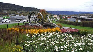
Terrace is a city located near the Skeena River in British Columbia, Canada. The community is the regional retail and service hub for the northwestern portion of British Columbia. With a current population of over 12,000 within municipal boundaries, the city services surrounding communities as well bringing the Greater Terrace Area population to over 18,000 residents. The Kitselas and Kitsumkalum people, tribes of the Tsimshian Nation, have lived in the Terrace area for thousands of years. The individual Indigenous communities neighbour the city with Kitselas to the east and Kitsumkalum to the west.
Copper River may refer to several places:

The Skeena River is the second-longest river entirely within British Columbia, Canada. Since ancient times, the Skeena has been an important transportation artery, particularly for the Tsimshian and the Gitxsan—whose names mean "inside the Skeena River" and "people of the Skeena River," respectively. The river and its basin sustain a wide variety of fish, wildlife, and vegetation; and communities native to the area depend on the health of the river. The Tsimshian migrated to the Lower Skeena River, and the Gitxsan occupy territory of the Upper Skeena.

Skeena—Bulkley Valley is a federal electoral district in British Columbia, Canada, that has been represented in the House of Commons of Canada since 2004.

Thutade Lake is located in the Omineca Mountains of the Northern Interior of British Columbia, Canada. About 40 km in length, and no more than about 2 km wide, the lake is primarily significant as the ultimate source of the Mackenzie River. The lake is at the head of the Finlay River, which joins the Peace River via Williston Lake. The area is very remote, being located about 260 km north of Smithers, although several mining operations for ores containing copper, lead, zinc and silver have occurred around the lake. The largest of these is the Kemess Mine, an iron and copper property originally owned by Royal Oak Mines and now by Northgate Minerals, located in the valley of Kemess Creek, which is off the northeast end of Thutade Lake. The mine is accessed by the Omineca Resource Road and other resource routes, and is 400 km by road from Prince George. Just downstream from the outlet of Thutade Lake, the Finlay plunges over 180-foot (55 m) Cascadero Falls, and then through a series of cataracts in a twisting course until it begins its main northeastward trend. Cascadero Falls is slated for hydroelectric development in connection with the power needs of the area's mines.
Exchamsiks River Provincial Park is a provincial park in British Columbia, Canada, located in the Range 5 Coast Land District, on the north side of the Skeena River between Terrace and Prince Rupert. The park's chief conservation role focuses on protecting one of the last known unlogged old-growth maritime coastal Sitka spruce-salmonberry ecosystems.

Lower Skeena River Provincial Park is a provincial park in British Columbia, Canada.
Sandspit is the largest community on Moresby Island, in Haida Gwaii off the Pacific coast of British Columbia, Canada. The only town on Moresby Island, Sandspit has accommodations, a campground, supermarket and 85-berth harbour serving visitors to Gwaii Haanas.
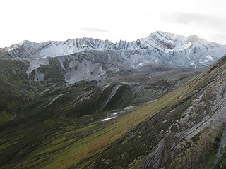
The Skeena Mountains, also known as the Skeenas, are a subrange of the Interior Mountains of northern British Columbia, Canada, essentially flanking the upper basin of the Skeena River. They lie just inland from the southern end of the Boundary Ranges of the Coast Mountains, and also of the northern end of the Kitimat Ranges. Their southern limit is described by the Bulkley River and the upper northwestern reaches of Babine and Takla Lakes, and on their northeast by the upper reaches of the Omineca River.

The Hazelton Mountains are a grouping of mountain ranges on the inland lee of the Kitimat Ranges of the Coast Mountains in northwestern British Columbia, Canada, spanning the area of Hazelton south to the Nechako Reservoir. Defined by the British Columbia geographic names office, they span from the Nass River to the Nechako Plateau, and between the Coast Mountains and the Bulkley River, they are considered by geographers to be part of the Interior Mountains complex, though in local perspective they are considered to be part of the Coast Mountains. They are neighboured on the west by the Kitimat Ranges and on the east by the southernmost section of the Skeena Mountains; beyond the Nass River, which is their northern boundary, are the Boundary Ranges of the Coast Mountains. To their southeast is the Nechako Plateau, including the Quanchus Range on the near-island between Ootsa and Eutsuk Lakes of the Nechako Reservoir.

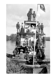
The Skeena River is British Columbia’s fastest flowing waterway, often rising as much as 17 feet (5.2 m) in a day and fluctuating as much as sixty feet between high and low water. For the steamboat captains, that wide range made it one of the toughest navigable rivers in British Columbia. Nevertheless, at least sixteen paddlewheel steamboats plied the Skeena River from the coast to Hazelton from 1864 to 1912.

The Skeena sternwheeler was one of five sternwheelers built for the use on the Skeena River by Foley, Welch and Stewart for construction work on the Grand Trunk Pacific Railway from 1909 until 1911. She was built at Robertson's yard in Coal Harbour, Vancouver, in 1908. The other four were the Conveyor, the Operator, the Distributor and the Omineca. Three of these, the Conveyor, the Operator and the Distributor were built at Victoria, British Columbia in 1908 by Alexander Watson Jr.
John Henry Bonser was a steamship captain from Oregon, United States and British Columbia, Canada. He piloted dozens of sternwheelers over his 40-year-long career and pioneered many rivers in the Pacific Northwest.

The Inlander was a sternwheeler that worked on the Skeena River in British Columbia, Canada from 1910 until 1912. She was owned by the Prince Rupert and Skeena River Navigation Company which was a syndicate of Skeena River businessmen who planned to use the Inlander as a passenger and freight steamer during the busy years of Grand Trunk Pacific Railway construction.
Little Canyon may refer to:
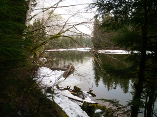
The Little Canyon is a stretch of the Skeena River near the city of Terrace, British Columbia, Canada in the northwestern part of that province. The canyon was named for Dudley Little, one of the founders of the city of Terrace. The canyon lies upstream from Ferry Island and below the adjacent railway and highway bridge.
The Skeena Country is a historic geographic region comprising areas of both the British Columbia Coast and the British Columbia Interior in northwestern British Columbia, Canada.
The Sicintine Range is a small subrange of the Skeena Mountains of the Interior Mountains, located south of the Skeena River and between the Sicintine River and Squingula River in northern British Columbia, Canada.
The Slamgeesh Range is a small subrange of the Skeena Mountains of the Interior Mountains, located between the Skeena River and Slamgeesh River in northern British Columbia, Canada. The Mosque River, a tributary of the Skeena, flows through the Slamgeesh Range.
Mount Thomlinson is a mountain in the Babine Range of the Skeena Mountains in northern British Columbia, Canada, located at the head of Thomlinson Creek, southeast of the junction of Babine River and Skeena River and north of Hazelton. It has a prominence of 1,661 m (5,449 ft), created by the Babine-Stuart Pass, thus making it one of Canada's many Ultra peaks. Thomlinson is one of the most isolated mountains of Canada.


